Download
1 / 1
10 likes | 108 Vues
Learn about effective strategies to reduce diamondback terrapin bycatch in commercial and recreational blue crab fisheries. Discover habitat suitability, management approaches, and conservation efforts.

E N D
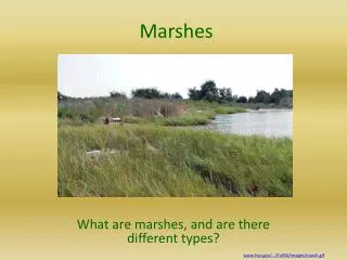
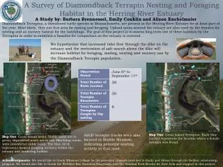
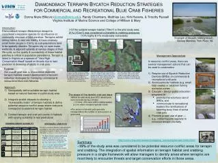
Diamondback Terrapin Bycatch Reduction Strategies for Commercial and Recreational Blue Crab Fisheries Gwynn Island – Milford Haven Lower York & Severn rivers Donna Marie Bilkovic (donnab@vims.edu), Randy Chambers, Matthias Leu, Kirk Havens, & Timothy Russell Virginia Institute of Marine Science and College of William & Mary Introduction Diamondback terrapin Malaclemys terrapin is considered a keystone species for its influence on community structure of tidal marshes. Terrapins exhibit strong habitat & nest site fidelity, & have relatively small home ranges (< 2 km), so sub-populations tend to be spatially discrete. Terrapins rely on open water, wetlands, & adjacent uplands at various stages of their life-cycle, so the quality & connectivity of these habitat patches is critical to population persistence. Terrapin is listed in Virginia as a species of "Very High Conservation Need" based on threats due to nest predation & drowning of adults in crab pots. • Of the suitable terrapin habitat (70km2) in the pilot study area, 21% (15 km2) was considered vulnerable to crabbing pressures (10% highly &11% moderately vulnerable) Example of terrapin nesting beach, Guinea Marshes, York River, VA Gwynn Island Severn River Management Approaches Milford Haven Guinea Marshes • In resource conflict areas, there are several management options that can be used in combination • Require use of Bycatch Reduction Devices (BRDs) on commercial & recreational crab pots • Avoid particular habitats (e.g. small tidal creeks) or establish fishing exclusion zones • Educate – design public education programs to • promote the voluntary use of BRDs, and • communicate to recreational boaters the ramifications of severing buoy lines of active crab pots • Promote proper use of gear — • e.g., retrieving pots regularly to minimize terrapin mortality Sarah’s Creek PerrinCreek Purpose Our overall goal was to characterize essential terrapin habitats toward development of bycatch reduction strategies for managing commercial & recreational blue crab fisheries. Results of terrapin occurrence, habitat suitability and crab pot distribution allow for the targeting of candidate zones for the application of blue crab fishery management actions to reduce bycatch. *Terrapin & crab pot field survey locations are enclosed with boxes. The lower York and Severn rivers contain extensive suitable terrapin habitat, however terrapin were absent in select creeks (e.g., Sarah’s Creek). Likely reasons are the lack of extensive marshes & the presence of anthropogenic stressors including residential development & crabbing pressures. Areas of concern for bycatch mortality include Perrin Creek, Cuba Island, Guinea marshes, & Severn River. The south side of Gwynn Island, Milford Haven and Stutts creek contain highly suitable terrapin habitat & high fishing pressure on the basis of distribution and abundance of derelict & active crab pots. Approach Geospatially define suitable terrapin habitat based on natural features in a pilot study area Integrate spatial datasets to develop a "Vulnerability Index" of terrapin habitats & define potential resource conflict areas where crab pots correspond to essential terrapin habitat 3) Conduct terrapin and crab pot counts in habitats with varying suitability to test predictions • The scope of the derelict crab pot issue • Within the pilot study area 2872 derelict pots were removed during 2 winters • Of these, 22% were within shallow waters (≤ 2 m) where terrapins typically reside • The amount of derelict pots generally corresponds to the number of active pots in a given area TERRAPIN HABITAT SUITABILITY Explanatory variables used to characterize suitable habitat • STRESSORS: CRAB POTS • Terrapin population declines, reduced growth, & changes in sex ratios have been directly attributed to bycatch mortality in commercial crab pots e.g., Dorcas et al. 2007; Wolak et al. 2010 Gwynn The Marine Debris Location and Removal Program (under the direction of VIMS &VMRC) employed commercial fishers to locate and remove lost or derelict blue crab pots from Virginia waters in 2008–2012 http://ccrm.vims.edu/marine_debris_removal/index.html. To date, approximately 30,000 derelict crab pots have been located, removed and bycatch information recorded. http://ccrm.vims.edu/research/mapping_surveying/terrapin/index.html Summary ~15% of the study area was considered to be potential resource conflict areas for terrapin and crabbing. The integration of spatial information on terrapin habitat and crabbing pressure in a single framework will allow managers to identify areas where terrapins are most likely to encounter threats and target conservation efforts in those areas. • With these data, we applied a moving window analysis in GIS to categorize relative crabbing pressure in relation to suitable terrapin habitat