Download
1 / 28
280 likes | 440 Vues
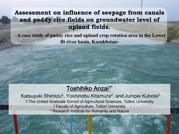
Assessment on influence of seepage from canals and paddy rice fields on groundwater level of upland fields . –A case study of paddy rice and upland crop rotation area in the Lower Ili river basin, Kazakhstan-. Toshihiko Anzai 1 *

E N D
Assessment on influence of seepage from canals and paddy rice fields on groundwater level of upland fields. –A case study of paddy rice and upland crop rotation area in the Lower Ili river basin, Kazakhstan- Toshihiko Anzai1* Katsuyuki Shimizu2, Yoshinobu Kitamura2, andJumpei Kubota3 1:The United Graduate School of Agricultural Sciences, Tottori University 2 Faculty of Agriculture, Tottori University 3Research Institute for Humanity and Nature
Introduction Environmental problems coursed by agricultural land development • Agricultural land development in Central Asia • The Great Plan for the Transformation of Nature • The development policy of virgin land In Kazakhstan, more than 10 million ha of grass land was transformed into agricultural land • Environmental problems • Huge amount of water withdrawal • Water use adjustment Central Asia 1989 2011 2003 http://earthobservatory.nasa.gov/Features/WorldOfChange/aral_sea.php
Introduction The relation between Lake Balkhash and Ili River • Lake Balkhash • Lake Balkhash has become the largest in Central Asia. • Discharge of Ili River accounts for 80% of inflow to Lake Balkhash. • → The water level of Lake Balkhash is affected by Ili River discharge. • Ili River –Cross boundary river- Lower Ili River Basin Tien Shan http://earthobservatory.nasa.gov/IOTD/view.php?id=49857 Kapchagai reservoir Water use adjustment Middle Ili River Basin vs
Introduction Agriculture in Lower Ili River • Lower Ili River basin • The large irrigated agriculture has been conducted since 1960’s. • The irrigated land is about 30 thousand ha. • Agriculture in lower Ili river basin • Paddy rice and upland crops rotation system • Upland crops use the groundwater which is raised by seepage from canals and paddy rice fields. • The problems that is concerned in this irrigation district • The possibility of decreasing amount of water withdrawal • Water logging and salinization Water logging Salinization
Objectives VS Possibility of decreased amount of water withdrawal in the lower Ili River Basin • It is necessary to survey agricultural sustainability from the aspect of agricultural water and land use. • We investigate and clarify • Influence of the seepage from canals and paddy rice • fields on condition of water supply to upland fields
Outline of study area Akdara Irrigation district Kazakhstan Lake Balkhash China Ili river Kapchagai reservoir Google earth
Outline of study area • Agricultural activity has been conducted by collective farming. • Outline of farm land Rotation block Farm block monoculture Farm lot 1~2 ha ×50 15000 ha • The control of salinization by crop rotation The leaching of accumulated salt Rotation block Paddy rice Paddy rice Paddy rice The progress of salinization Upland Upland Upland Upland
Outline of study area • Outline of irrigation system • All the irrigation canals are unlined. • →Large amount of water seep into the ground. • →Conveyance and distribution efficiency is 45 %. • Irrigation method • 【Paddy rice field】 • ・Continuous irrigation is practiced. • 【Upland field】 • ・Irrigation is practiced once or twice • in beginning of growing season. • →Upland crops use the groundwater which is raised by seepage • from canals and paddy rice fields. Main canal Paddy rice field Upland field
Methodology • Influence of seepage from canals and paddy rice fields on groundwater level was investigated in upland field. Installment of observation wells ii Level survey on groundwater level and ground surface
Methodology • The condition of water supply to upland field was clarified by using result of groundwater level survey and GIS. The area is affected by seepage from canals and paddy rice fields. Upland field area A Canal B Paddy rice field ii i B iii The ratio = A
Result • The influence of the seepage from canals • Groundwater level survey which was conducted in 2011 • At the point close to the canal • Groundwater level was about 3.5 m from ground surface in non-irrigation period. • was about 1.5 m in irrigation period. • From the point close to canal • During irrigation period, groundwater level fell with increase in the distance from canal • At a distance of 300 m from canal • Groundwater level during irrigation period was almost equal to the level in non-irrigation period. Groundwater level was raised by about 2.0 m by seepage from canal.
Result • The influence of the seepage from paddy rice field • Groundwater level survey which is conducted in 2011 • At the point close to the paddy rice field • Groundwater level was about 3.0 m from ground surface in non-irrigation period. • was about 1.0 m from ground surface in irrigation period. • From the point close to paddy rice field • During irrigation period, groundwater level fell with increase in the distance from paddy rice field • At a distance of 400 m from paddy rice field • Groundwater level during irrigation period was almost equal to the level in • non-irrigation period. Groundwater level was raised by about 2.0 m by seepage from paddy rice field
Result • The influence of the seepage from paddy rice field • Groundwater level survey which is conducted in 2010 • At the point close to the paddy rice field • Groundwater level fell sharply from neighboring point close to the canal to point about 500 m. • From the distance, groundwater level fell gently.
Result • The influence of the seepage from canals and • paddy rice fields In light of these results, seepage can raise groundwater level and extent of groundwater level which can use for upland crops is 500m.
Result • The ratio of area organized by ratio of upland field area covered by the extent of the influence Upland field area A Canal B Paddy rice field ii i The upland field area which is not affected by seepage from canals and paddy rice fields was very low. B iii The ratio = A Influence of the seepage on condition of water supply to upland fields is considered to reach whole upland fields in irrigation district.
Result • The influence of the seepage from canals • The ratio of paddy rice field • Irrigation district has maintained the ratio of paddy rice field area to 30 % to 40%. • The relation between paddy rice field area and water supply from seepage is not observed.
Result • The effect of position of paddy rice fields on extent of the seepage from canals and paddy rice fields. 2007 2008 • In case that paddy rice field does not exist, • water does not flow in canal. According to position of paddy rice fields, extent of influence of seepage changed.
Conclusion Land use system • Paddy and upland crop rotation system • Protection of salinization • Irrigation management is only for paddy rice field . • Upland crops use groundwater whose level was raised by seepage. Water use system Influence of seepage • Influence of the seepage from canals and paddy rice fields is considered to 500 m. • Seepage from canals and paddy rice fields • can supply water to whole upland field. Water supply to Upland field • The condition of water supply was affected by position of paddy rice fields.
Future plan It is imperative to conduct Prediction of groundwater level in case that water withdrawal decreases. Recommendation of appropriate water management for sustainability of irrigation district Development of groundwater flow model
Outline of study area • Meteorological data • Annual precipitation is about 100 mm. • Average monthly precipitation during irrigation period • isabout 10 mm. Irrigation is essential to crop production in this study area.