Hydrological Assessment of Triple M Ranch Wetland Restoration Project
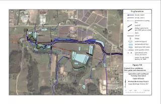
This document presents a comprehensive analysis of hydrological conditions and features at the Triple M Ranch Wetland Restoration Project. It examines various flow paths and obstructions, sediment deposits, and water quality stations, emphasizing the impact of minor stormwater and spring flows. The assessment includes data regarding road fill, dredge spoils, and ditch culverts, utilizing satellite imagery from Google Earth as of January 21, 2005. This project aims to enhance land and water interaction by understanding the existing hydrological framework.

Hydrological Assessment of Triple M Ranch Wetland Restoration Project
E N D
Presentation Transcript
50x100 100 x 200 100 x 200 Explanation stream, major stream, minor stormwater or spring flow road fill dredge spoils berm (pre-1980 unless noted) ditch culvert bridge sediment deposit unchannelized flow backwater/still water water quality station agricultural wells: in use, not in use image: Google Earth January 21, 2005 X option A option B option C CARNE31 Figure XX Typical flow conditions: flow paths and obstructions ? Agriculture and Land Based Training Association Triple M Ranch Wetland Restoration Project Largay Hydrologic Sciences, LLC