Download
1 / 75
750 likes | 758 Vues
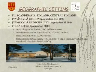
Geographic Literacy. GEOIC20F Ms. Crook. What is Geography?. Geography deals with the description, distribution and interaction of the diverse physical, biological and cultural features of the Earth’s surface. Examples. Where does our food come from? Layout of cities

E N D
Geographic Literacy GEOIC20F Ms. Crook
What is Geography? • Geography deals with the description, distribution and interaction of the diverse physical, biological and cultural features of the Earth’s surface.
Examples • Where does our food come from? • Layout of cities • Why do people vacation in Mexico? • Trade with other nations • Tornadoes • Why is Alberta so rich? • Why are Manitoba winters so cold?
A Day in the Life • Write a brief account of a day in the life of you! • This account might include the following: • What do you do when you get up in the morning? • Eating breakfast • Watching TV • How do you get to school? • What do you do after school? • Please include at least 7 references to Geography and explain how each is related to Geography.
Physical and Human Geography • Textbook definition: Geography is the study of the Earth’s physical and human systems and the relationship among them. • During this portion of the unit we will be exploring these two branches of geography and how they influence each other.
Physical Geography • Physical Geography is the branch of geography concerned with natural features and phenomena of the Earth’s surface, as landforms, drainage features, climates, soils, and vegetation.
Human Geography • A political/cultural branch of geography concerned with the social science aspect of how the world is physically arranged. • Geographical distribution of humankind • Relationships between human and their environments • Creation of a cultural landscape
Potential Changes in Human and Physical Geography What can cause physical changes? • Tectonic Movement: tectonic plates moving beneath the Earth’s surface can cause landforms to shift. • Erosion: the gradual wearing away of the Earth’s surface due to wind or water. • Glaciation: The advancing or receding of glaciers (icecaps) that scrape away the Earth’s surface. What can cause Human Changes • Technology • Development • Population Increase
Relation Between Human and Physical. Instructions • Read the article assigned to you. (There are four different articles being read.) • Fill in the boxes on page 8. (Individually) • You will be placed in a group with individuals who read a different article than you. • Each group member will have the opportunity to share their responses on page 8 with the remaining members of the group. • As each group member shares, the results should be recorded into the chart on page 9. • Once all group members have had an opportunity to share, collectively answer the final question at the bottom of page 9.
Location • Location is a description used to define where something is situated. • Can be used to pinpoint a particular place, or the distance between destinations. • We use location daily in order to meet a friend in the mall, drive from city to city or find our way when we are lost. • The study of geography requires a variety of measurement tools in order to gain an understanding of geographic elements and communicate these to others.
Compass Points and Bearings • Used to dictate locations using four major directions. These four directions are known as the cardinal points. • North • South • East • West • In order to increase accuracy, four more ordinal points are located between each of these main points. They are as follows: • North-west • North-east • South-west • South-east • Once again to increase accuracy, additional points are added between each of the eight points. • Example: North North-East, South South-West
Compass Rose • All of these points are displayed on a compass rose. • The accuracy of these directions can also be increased by giving the points in degrees, otherwise known as compass bearings. • 0°, 90°, 180°, 270°
0° • 337.5° • 22.5° • 315° • 45° • 292.5° • 67.5° • 270° • 90° • 112.5° • 247.5° • 225° • 135° • 202.5° • 157.5° • 180°
Latitude and Longitude • Latitude and Longitude is a grid system that divides the world into grid squares. • There are invisible lines that circle the world from top to bottom and side to side. • This system gives each place on the globe an address composed of two numbers. • This address is dictated by the place where the line of latitude and longitude intersect.
Latitude • Lines that run side to side are known as lines of latitude. • They dictate how far locations are from the equator which is located at 0° • The north and south poles are located at 90° • Other important lines are the Tropic of Cancer (23.5°N) and the Tropic of Capricorn (23.5°S)
Longitude • Lines that run up and down are known as lines of longitude. • They dictate how far locations are from the Prime Meridian which is located at 0° • Longitude locations are stated in degrees East or West of the Prime Meridian.
Using Latitude and Longitude • When trying to pinpoint a location, the latitude is measured and recorded first followed by the longitude. • Example: Winnipeg is located at 49°N, 97°W
How to Label a Map • Title your map (what are you showing?) • Put your name on the map(s) • Read and follow directions carefully • Labelling cities – place a dot and print the name (small and neat) beside it rivers– write the name along the river (follow it) lakes/oceans/bays – write name in the body of water mountains – draw ^^ or shade the area then write the name along the land feature
Tracing/colouring • Work carefully • Note the difference b/w rivers, coasts and political boundaries • Trace the full extent of the river (source to mouth) • Don’t use pen • If you don’t have space use a line/arrow and write on the side
Map Projections • A map projection is a method used to transfer features on the globe onto the flat surface of a map. • There are hundreds of ways this can be done and hundreds of different projections. • Each projection has its strengths and weaknesses. **Instructions • Examine the following map projections and record what you notice about the positioning of the continents.
The Peters Projection • Created in 1973 by German historian and journalist Arno Peters. He boasted that his projection was better than others because it represented area accurately. Thus treating all countries equally. • Media stated that the Peters Projection “made things right for the oppressed world.” • Criticism: The Peters Projection has been described as looking like wet clothes hanging to dry on the Arctic Circle. • Very few organizations still use the Peters Projection.
Mercator Projection • The Mercator Projection was developed in 1569 by Gerardus Mercator as a navigation tool. • The parallel and straight lines of latitude and longitude was beneficial to sailors due to the fact that it allows a constant compass bearing. • Criticism: The Mercator Projection was criticised because it supposedly distorts the size of countries in the Northern hemisphere. • North America, Greenland and especially Europe appear much larger than those in the Southern hemisphere. • This distortion was said to be representative of the advantage of the colonial powers. (Inequality of importance.)
The Winkel Tripel Projection • The Winkel Tripel Projection was developed in 1921 by Oscar Winkel. • The word Tripel (German for “a combination of three elements”) is used because the map attempts to minimize the distortions of area, distance and direction. • The Winkel Tripel Projection was not commonly used until 1998 when it was adopted by the National Geographic Society. • The Projection is now the standard projection for maps of the world.
The Winkel Tripel Projection • Pros: • The Winkel Tripel Projection is considered more realistic because it has curved lines of latitude and longitude. • The Winkel Tripel Projection is considered to be the least skewed of the many projections. • Cons: • The polar regions are distorted to the far East and West. • Due to the fact that the Projection attempts to minimize distortions of shape, distance and direction, there are small distortions in each area.
Time Zones • Time Zones are a division of the Earth’s surface, usually extending across 15 degrees of longitude, that establishes a uniform time. • Each time zone is roughly 15 degrees due to the fact that the Earth rotates 360 degrees over 24 hours. • 360/24 = 15 • Every place within that time zone has the same time and is therefore referred to as standard time. • The Prime Meridian is included in a time zone called Universal Time. • Due to the fact that the Earth rotates from west to east, time zones west of the PM are earlier and time zones east of the PM are later. • In Canada, the more east you go, the later the time is. The more west you go, the earlier it is.
Time Zone Questions • Calculate what time it would be in the following locations using your knowledge of time zones: • If it is 2:00pm in Central time, what time is it in Eastern time? • If it is 5am in Atlantic time, what time is it in Mountain time? • If it is 7pm in Pacific Time, what time is it in Eastern time? • If it is 4am in Newfoundland time, what time is it in Central time? • If it is 6pm in Mountain time, what time is it in Eastern time? Answers 3pm 2am 10pm 1:30am 8pm
Harder Time Zone Questions • If it is 1am in Vancouver, what time is it in Brandon? • If it is 9pm in Toronto, what time is it in Calgary? • If it is 5:30pm in Halifax, what time is it in Montreal? • If it is 2:00pm in St. John’s, what time is it in Winnipeg? • If it is 4pm in Fredericton, what time is it in Victoria? • If it is 3am in Edmonton, what time is it in Regina? (Daylight savings) • If it is 8:30pm in Saskatoon, what time is it in Hamilton? (winter time)? Answers: 3am 7pm 4:30pm 11:30am 12pm 3am 9:30pm
Scavenger Hunt Activity • Use your knowledge of latitude, longitude, Time zones, GPS, GIS and satellites to answer the following questions. You may use your atlases (page 2,3) • The multiple choice questions will provide you with a direction instruction for each answer (a, b, c) • When you have selected your answer, move locations according to the directions next to the letter selected. • Plot each location on the blank map on the next page. • Once you have answered all of the questions, record your final location on the map.
Canadian Landform Region • You will be shown a series of pictures of the Canadian landscape. Your task is to find the trends amongst the pictures. • Look for things that are similar and different from image to image.
Rockies Alberta
Northwest Territories Newfoundland
Mackenzie Mountains North of Toronto
Northern Northwest Territories Northern Quebec and Labrador
French Manitoba Prince Albert Saskatchewan
Lake of the Woods Southern Ontario