Download
1 / 20
210 likes | 413 Vues
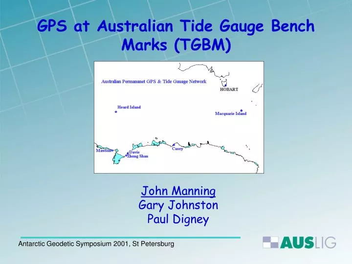
GPS at Australian Tide Gauge Bench Marks (TGBM). John Manning Gary Johnston Paul Digney. Background. A network of Tide Gauges deployed at Australian Antarctic Stations in 1992/1993. Including the establishment of TGBMs in close proximity Continuous GPS Stations - Part of the

E N D
GPS at Australian Tide Gauge Bench Marks (TGBM) John Manning Gary Johnston Paul Digney Antarctic Geodetic Symposium 2001, St Petersburg
Background A network of Tide Gauges deployed at Australian Antarctic Stations in 1992/1993. Including the establishment of TGBMs in close proximity Continuous GPS Stations - Part of the AUSTRALIAN Regional GPS Network (ARGN), established at each permanent Australian Station in 1993/1994. Establishment in 1995 of the Southern Ocean Sea Level Centre to foster international cooperation into Southern Ocean sea level research Antarctic Geodetic Symposium 2001, St Petersburg
Activities 2000/2001 Summer • EDM-Heighting technique used to connect GPS • to TGBM at both Mawson and Davis Stations • 3 days GPS data observed at Davis, Mawson and • Larsemann Hills TGBMs Antarctic Geodetic Symposium 2001, St Petersburg
A comparison of GPS Heighting and Orthometric levelling between the ARGN mark and the TGBM. Antarctic Geodetic Symposium 2001, St Petersburg
MAWSON TGBM Antarctic Geodetic Symposium 2001, St Petersburg
MAWSON Permanent GPS Antarctic Geodetic Symposium 2001, St Petersburg
http://www.auslig.gov.au/geodesy/antarc/mawsontg.htm Antarctic Geodetic Symposium 2001, St Petersburg
Level Connections at Mawson Antarctic Geodetic Symposium 2001, St Petersburg
Permanent GPS at Davis Station Antarctic Geodetic Symposium 2001, St Petersburg
EDM Height Traversing “Leap Frogging” Technique Variant of the common technique of spirit levelling, where the differences in height between change points are determined using observations of zenith angles and slope distances. Use of Leica TLC2000 Total Station and single fixed height survey rod and reflector Atotal of 12 measurements taken to both backsight and foresight Sight lengths kept below 50 metres Misclose to comply with allowable maximum for SP1 Class LA - 4k Antarctic Geodetic Symposium 2001, St Petersburg
Level Connections at Davis Station Antarctic Geodetic Symposium 2001, St Petersburg
NMVS4 Original TGBM at Davis Antarctic Geodetic Symposium 2001, St Petersburg
http://www.auslig.gov.au/geodesy/antarc/davistg.htm Antarctic Geodetic Symposium 2001, St Petersburg
Attempting to transfer MSL from the Tide Gauge at Davis to the TGBM Antarctic Geodetic Symposium 2001, St Petersburg
Permanent GPS at Casey Station Antarctic Geodetic Symposium 2001, St Petersburg
http://www.auslig.gov.au/geodesy/antarc/caseytg.htm Antarctic Geodetic Symposium 2001, St Petersburg
TGBM Network Casey Station Antarctic Geodetic Symposium 2001, St Petersburg
Australian TGBM (AUS334) Larsemann Hills Antarctic Geodetic Symposium 2001, St Petersburg
Future Program • Continue monitoring the vertical connection • between GPS and TGBM, by: • levelling, by adopting at least 2nd order standards • Repeat GPS observations on TGBMs at each Station • Continue the development of fixed levelling routes • to maintain consistency Antarctic Geodetic Symposium 2001, St Petersburg