Download
1 / 16
160 likes | 320 Vues
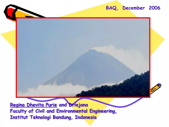
BAQ, December 2006. CONTRIBUTION OF MOUNT MERAPI VOLCANO EMISSION DURING QUIESCENT STATE TO BACKGROUND SO 2 CONCENTRATION IN D.I. YOGYAKARTA PROVINCE. Regina Dhevita Purie and Driejana Faculty of Civil and Environmental Engineering, Institut Teknologi Bandung, Indonesia. Background.

E N D
BAQ, December 2006 CONTRIBUTION OF MOUNT MERAPI VOLCANO EMISSION DURING QUIESCENT STATE TO BACKGROUND SO2 CONCENTRATION IN D.I. YOGYAKARTA PROVINCE Regina Dhevita Purie and Driejana Faculty of Civil and Environmental Engineering, Institut Teknologi Bandung, Indonesia
Background • SO2 emission from Merapi volcano might contribute to SO2 ambient air concentration in the surrounding area • Volcanic emission during quiescent state might have impact to environment, however monitoring to emission and its impacts have not got much attention
Objectives • To examine the spatial distribution of SO2 from Mt. Merapi during normal activity within the volcano surrounding area • To observe its potential impact to the environment
Boundary conditions • The point source emission is assumed to be continuous • The dispersion prediction is carried out within an area of 13.5 km X 13.5 km surrounding Merapi including Kabupaten Magelang, Kabupaten Boyolali, Kabupaten Klaten in Central Java and Kabupaten Sleman in DI Yogyakarta
Methodology • Collecting primary data from Volcanology Agency for emission data (Q) and plume rise (∆h) from COSPEC measurement in 2002, wind speed, wind direction and atmospheric stability from the Met Office, and topographical data such as the height of mountain and the altitude of receptor area • Modeling based on Gaussian Plume Model for daily average concentration during dry season period (April – September) • Ambient air sampling of SO2 to validate the model • Observing the evidence of SO2 impact to surrounding area of Mt.Merapi
Boyolali Magelang Klaten DIY Mt. Merapi Study Area
Results and discussion • The prevailing winds were from south, southwestern and southeastern directions • The daily dispersion patterns are found to be similar • Six days (a day in every month) are taken as the examples for the predicted dispersion pattern
April 5th May 23th June 7th Kab. Boyolali Kab. Boyolali Kab. Boyolali Kab. Magelang Kab. Magelang Kab. Magelang Kab. Klaten Kab. Klaten Kab. Klaten DIY DIY DIY Mt. Merapi The dispersion pattern of SO2 SO2 unit of concentration: µg.m-3
Agst 13th July 12th Sept 15th Kab. Boyolali Kab. Boyolali Kab. Boyolali Kab. Klaten Kab. Magelang Kab. Magelang Kab. Magelang Kab. Klaten Kab. Klaten DIY DIY DIY Mt. Merapi The dispersion pattern of SO2 Unit concentration of SO2: µg.m-3
The average concentration of SO2 from April to September 2002 was 23.09 µg.m-3 ,with the maximum daily concentration SO2 of 490.72 µg.m-3and the minimum daily concentration of 2.77 µg.m-3 • The maximum concentrations mostly fall within the distance of 0.6 – 3.4 km from the center of the volcano
Kab. Boyolali Kab. Magelang Mt. Merapi Kab. Klaten Kab. Sleman, DIY Receptor points The areas where SO2 deposition are most likely to happen
Necrosis & colourosis colourosis colourosis Visible indication of the SO2 impacts to plantation The damage of plantation, such as cabbage, tobacco, tea, and the root of tobacco plant
9170 Tobacco plantation at Dusun Jerakah (438.138,36; 9.170.352,19; 1291,5) Soil Condision at Dusun Jerakah (438.138,36; 9.170.352,19; 1291,5) 9165 9160 0435 0440 The impact SO2 to soil and tobacco plant
Conclusions and Recommendation • Inventory emission from volcano is necessary, not only for the purpose of monitoring the volcanic activity, but also for mitigation of the emission impact • The locations of maximum concentration were found to be at the same grid locations, covering an area of about 400 to 800 hectares on the distance of 0.6 – 3.4 km in the north-eastern, northern and western of Mount Merapi. • The maximum concentrations of SO2 were found in Kabupaten Magelang, Kabupaten Boyolali and a little part of Kabupaten Klaten area. According to the land use, these areas can be considered as ecological sensitive area.
Indications of environmental impact caused by volcanic emission of Merapi have been seen, particularly on plantation and the form of soil. • Specific mitigation plans therefore might need to be developed for this area, to reduce the impacts to the minimal.