Download
1 / 7
70 likes | 75 Vues
Observing the Tropical Cyclone and its Environment: Current Capabilities and Future Outlook. Recent Success Stories: Satellite. Observing Systems: Saving of TRMM (for at least 3 more years)!! TOPEX for ocean heat content and QuikSCAT Communication

E N D
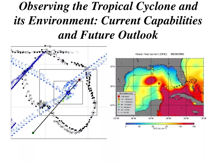
Observing the Tropical Cyclone and its Environment: Current Capabilities and Future Outlook
Recent Success Stories: Satellite • Observing Systems: • Saving of TRMM (for at least 3 more years)!! • TOPEX for ocean heat content and QuikSCAT • Communication • Real-time data access though links and web sites • Improved visualization methods • Use of Satellite Data: • Positive impact of sat data for SHIPS, • Data assimilation into NWP; • Objective Dvorak technique, R-Cliper • Multi-spectral approaches to analysing TCs (Intensity and Structure) • Objective indicators of annular storms and eyewall replacement cycles
Satellite Data in SHIPS • GOES predictors improve east Pacific forecasts by almost 10% • GOES and Ocean Heat Content improve Atlantic forecasts by 2-3% • Larger improvement for storms in high OHC areas • JHT project 2002-03 • Operational in 2004 TPC’s operational OHC product for Hurricane Katrina from satellite altimetry
Recent Success Stories: Aircraft • Superb effort by 53rd and NOAA on coping with an unprecedented hurricane season • First hurricane mission by a UAS • Upgraded real-time communication from P3s, enabling potential for use of radar data in NWP
6 6 6 9 9 9 Aerosonde Mission into Ophelia 16 Aug, 2005 NOAA WP-3D SFMR Surface winds in light blue, Aerosonde winds in black, buoy winds in dark blue. Aerosonde peak winds at 2500 ft were 65 kt southeast of center and 75 kt north of center. Excellent agreement between buoy, SFMR and Aerosonde winds adjusted to surface values. SFMR winds SW of center were within 10 min of aerosonde. 6
Observing Outlook • Aircraft: • SFMR implementation on C130s (delayed?) • UAS Operational trial • Satellite: • COSMIC, GPM, NPOESS, GOES-R+ • NRC Decadal Study Recommendations for future NASA (wind lidar, geo-microwave, GPS) • ***Many are delayed or on hold*** • Use of Data • 4DDA techniques tested (4DVar, EnKF) • Assimilation of radar data land-based and aircraft