Download
1 / 1
10 likes | 125 Vues
S08 S08 grid, Southern Louisiana. Sou Source: http://www.nd.edu/~adcirc/s20.htm. [NG-CHC] Cyber-Enabled Coastal Data Factory for the Northern Gulf. Lei Jiang 1,3 , Jian Tao 3 , Kelin Hu 2 , Haihong Zhao 2 , Steve Brandt 1,3 , Q. Jim Chen 2,3 and Honggao Liu 3

E N D
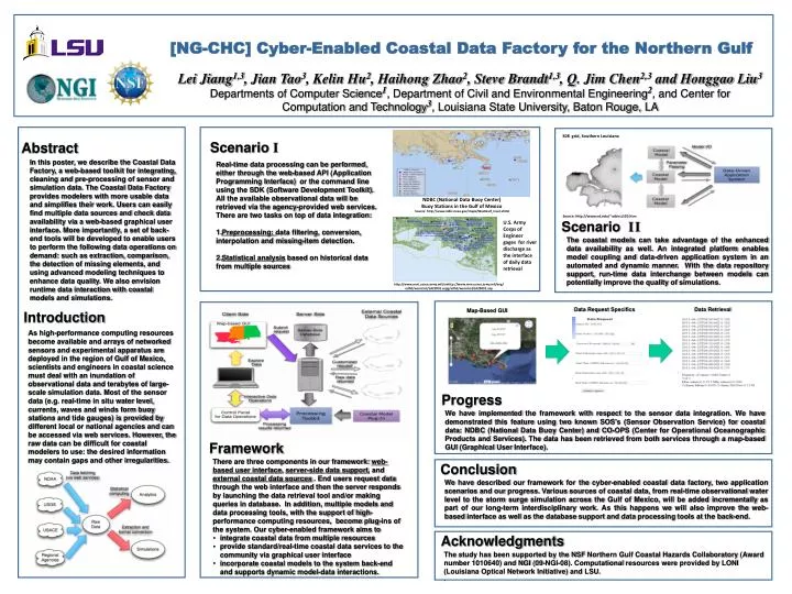
S08S08 grid, Southern Louisiana SouSource: http://www.nd.edu/~adcirc/s20.htm [NG-CHC] Cyber-Enabled Coastal Data Factory for the Northern Gulf Lei Jiang1,3, Jian Tao3, Kelin Hu2, Haihong Zhao2, Steve Brandt1,3, Q. Jim Chen2,3 and Honggao Liu3 Departments of Computer Science1, Department of Civil and Environmental Engineering2, and Center for Computation and Technology3, Louisiana State University, Baton Rouge, LA Scenario I Abstract In this poster, we describe the Coastal Data Factory, a web-based toolkit for integrating, cleaning and pre-processing of sensor and simulation data. The Coastal Data Factory provides modelers with more usable data and simplifies their work. Users can easily find multiple data sources and check data availability via a web-based graphical user interface. More importantly, a set of back-end tools will be developed to enable users to perform the following data operations on demand: such as extraction, comparison, the detection of missing elements, and using advanced modeling techniques to enhance data quality. We also envision runtime data interaction with coastal models and simulations. Real-time data processing can be performed, either through the web-based API (Application Programming Interface) or the command line using the SDK (Software Development Toolkit). All the available observational data will be retrieved via the agency-provided web services. There are two tasks on top of data integration: Preprocessing: data filtering, conversion, interpolation and missing-item detection. Statistical analysis based on historical data from multiple sources NDBC (National Data Buoy Center) Buoy Stations in the Gulf of Mexico SouSource: http://www.ndbc.noaa.gov/maps/WestGulf_inset.shtml U.S. Army Corps of Engineer gages for river discharge as the interface of daily data retrieval Scenario II The coastal models can take advantage of the enhanced data availability as well. An integrated platform enables model coupling and data-driven application system in an automated and dynamic manner. With the data repository support, run-time data interchange between models can potentially improve the quality of simulations. http://www.mvn.usace.army.mil/enhttp://www.mvn.usace.army.mil/eng/edhd/wcontrol/LA29091.aspg/edhd/wcontrol/LA29091.asp Data Request Specifics Data Retrieval Map-Based GUI Introduction As high-performance computing resources become available and arrays of networked sensors and experimental apparatus are deployed in the region of Gulf of Mexico, scientists and engineers in coastal science must deal with an inundation of observational data and terabytes of large-scale simulation data. Most of the sensor data (e.g. real-time in situ water level, currents, waves and winds form buoy stations and tide gauges) is provided by different local or national agencies and can be accessed via web services. However, the raw data can be difficult for coastal modelers to use: the desired information may contain gaps and other irregularities. Progress We have implemented the framework with respect to the sensor data integration. We have demonstrated this feature using two known SOS's (Sensor Observation Service) for coastal data: NDBC (National Data Buoy Center) and CO-OPS (Center for Operational Oceanographic Products and Services). The data has been retrieved from both services through a map-based GUI (Graphical User Interface). Framework • There are three components in our framework: web-based user interface, server-side data support, and external coastal data sources . End users request data through the web interface and then the server responds by launching the data retrieval tool and/or making queries in database. In addition, multiple models and data processing tools, with the support of high-performance computing resources, become plug-ins of the system. Our cyber-enabled framework aims to • integrate coastal data from multiple resources • provide standard/real-time coastal data services to the community via graphical user interface • incorporate coastal models to the system back-end and supports dynamic model-data interactions. Conclusion We have described our framework for the cyber-enabled coastal data factory, two application scenarios and our progress. Various sources of coastal data, from real-time observational water level to the storm surge simulation across the Gulf of Mexico, will be added incrementally as part of our long-term interdisciplinary work. As this happens we will also improve the web-based interface as well as the database support and data processing tools at the back-end. Acknowledgments The study has been supported by the NSF Northern Gulf Coastal Hazards Collaboratory(Award number 1010640) and NGI (09-NGI-08). Computational resources were provided by LONI (Louisiana Optical Network Initiative) and LSU. .