Download
1 / 33
410 likes | 498 Vues
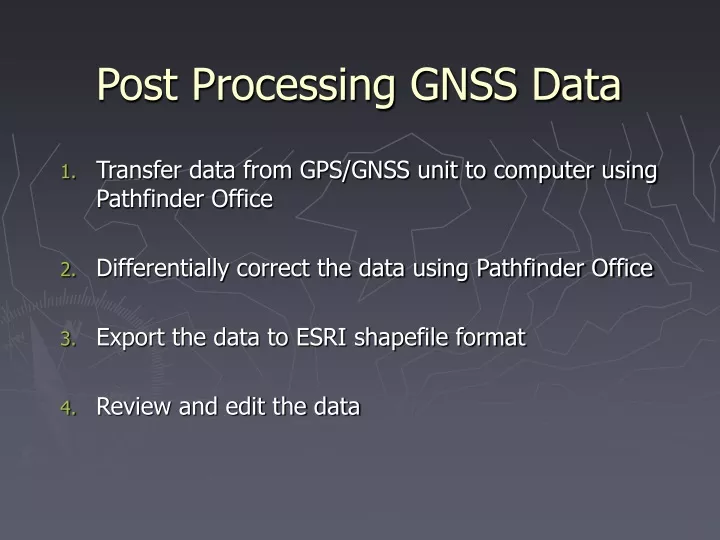
Post Processing GNSS Data. Transfer data from GPS/GNSS unit to computer using Pathfinder Office Differentially correct the data using Pathfinder Office Export the data to ESRI shapefile format Review and edit the data. 1. Transfer data from GNSS unit to computer.

E N D
Post Processing GNSS Data • Transfer data from GPS/GNSS unit to computer using Pathfinder Office • Differentially correct the data using Pathfinder Office • Export the data to ESRI shapefile format • Review and edit the data
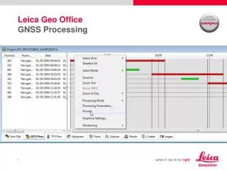
1. Transfer data from GNSS unit to computer • Connect the cables and place the GNSS unit in the cradle. • Open Pathfinder Office (PFO). • If you are not prompted to select or create a Project folder, go to File > Projects… and create a New project to hold your data files. • Select Utilities > Data Transfer
1. Transfer data from GNSS to computer • Highlight the Receive tab • Click “Add”, Data File • Select the GNSS rover files (a.k.a. “.SSF” files) that you created • Check that you are using the correct destination • Click “Open” files are highlighted if they’ve never been transferred
1. Transfer data from GNSS to computer • Click “Transfer All”
1. Transfer data from GNSS to computer • Click “Close” • Verify that files are in the correct directory location on the computer
2. Differential Correction with PFO • Differential correction is the process of removing known errors in GNSS data. Data collected by a base station (or stationary GNSS receiver) is used to correct for known errors in the GPS data. It can improve the accuracy of GNSS positions to sub-meter. • Most errors in GNSS come from effects on timing of the satellite signal. Timing effects can be adjusted if there is a receiver in a known location keeping track of errors. Differential correction (DGPS) uses two receivers: a reference or 'base receiver' that stays at a known location and a mobile 'roving receiver' that is used for the GNSS survey.
2. Differential Correction with PFO • The reference station receives the same GNSS signals as the roving receiver but instead of working like a normal GNSS receiver it attacks the equations backwards. • It figures out what the travel time of the GNSS signals shouldbe, and compares it with what they actually are. The difference is an 'error correction' factor.
2. Differential Correction with PFO • In PFO, choose Utilities > Differential Correction
2. Differential Correction with PFO • Click the button and browse to your .SSF file(s) • Click Next
2. Differential Correction with PFO • Select “Carrier and Code” Processing Type (single base provider if not grayed out) • Click Next
2. Differential Correction with PFO • Choose “Corrected only” for Output Positions • Use Automatic filtering for GPS Filtering (uses the filters applied in TerraSync) • Select “Re-correct real-time positions” • Click “OK” and then “Next”
2. Differential Correction with PFO • Choose Base Provider Search, and choose an appropriate station (usually one that is closest or has the highest Integrity Index) • Under Reference Position, choose Use reference location from the base files. • Check the Confirm base data and position before processing box. • Click Next
2. Differential Correction with PFO • Make any changes to the output folder or file naming • Click Start
2. Differential Correction with PFO • When asked to Confirm whether to continue, make sure that the base station was able to provide coverage for the entire time period when data were collected • Click Confirm and Close when differential correction is complete • All processing info is stored in Correct_date.txt file
2. Differential Correction with PFO • Confirm that corrected files (.COR) have been created in your project directory
2. Differential Correction with PFO TIPS • You can correct multiple SSF files if all were within 100 miles of each other • Use closest base station, CORS or COOP CORS only. Use a current station list (update at least monthly) • Always use “Use reference position from Base File” (puts your COR file in the most current form of NAD83. That is, NAD83 (2011) epoch 2010 • Strive for 100% differential correction • Archive entire GPS Project folder for maximum metadata
3. Exporting the Data to Shapefiles • .COR .SHP • Each feature name in the Data Dictionary will be exportedas a separate shapefile • In PFO, choose Utilities > Export…
3. Exporting the Data to Shapefiles • Browse to the corrected file(s) • Select output folder • Click New • Name your custom setup • Select Copy of existing setup • Choose ‘Sample ESRI Shapefile’
3. Exporting the Data to Shapefiles • For Type of Data, choose Features – Positions and Attributes, and Export All Features • If Between-feature-logging was used in field, Include Not In Feature Positions will show breadcrumb trail
3. Exporting the Data to Shapefiles • For our purposes, choose option 1 under Output Files • Places all shapefiles in the project’s Export folder
3. Exporting the Data to Shapefiles • For Export Menu Attributes As, choose Attribute Value. • Attributes from your Data Dictionary will automatically be included in the attribute table(s). However, you may select other Generated Attributes to include, as well.
3. Exporting the Data to Shapefiles • Select the correct units for the exported shapefile(s). Generally this is Meters, Sq. meters, and Meters Per Second. You may select these yourself or use the default Current Display Units if they are correct. • Select the desired number of decimal places for your units • Units affect shapefile attributes: Length, Area, Perimeter
3. Exporting the Data to Shapefiles • Choose Filter By GPS Position Info • Data collection settings should have already eliminated data from too high PDOP, etc., but you can repeat those settings here • Uncheck “Uncorrected” and at a minimum check “Postprocessed Code” for types of positions to include • Uncheck Filter By Precision and Include Non-GPS Positions
3. Exporting the Data to Shapefiles • Choose “Use Export Coordinate System” • Click Change and choose appropriate system and datum [NAD83 (CONUS)] • Click OK • Select a Projection File. If ArcGIS installed, coordinate systems folder found in C:\Program Files (x86)\ArcGIS\Desktop10.x\
3. Exporting the Data to Shapefiles • Export Tracking Themes only checked if using Tracking Analyst in ArcGIS • Click OK to finish editing Export Properties
3. Exporting the Data to Shapefiles • Click OK
3. Exporting the Data to Shapefiles • Click OK • Check that expected number of features is exported
3. Exporting the Data to Shapefiles • Click OK • Check that expected number of features is exported • When finished, you can click More Details… for a complete report on the success of the export
3. Exporting the Data to Shapefiles • Click OK • Check that expected number of features is exported, and click • Check that shapefile successfully added to Export folder
4. Review and Edit the Data • Do it ASAP, before collecting more data, if at all possible. • Check your memory and your field notes before you edit. • Keep a copy of the original unedited file! • Check features, attributes and spatial pattern.
4. Review and Edit the Data Point Features: Location • Is the point misplaced relative to other features or an expected pattern? • Check the corrected positions that the point is based on. Check field notes for constellation jumps, PDOP spikes. Point Features: Theme • Is the feature correct? • Are the attributes correct?
4. Review and Edit the Data Line and Area Features: Location • Are features in the right location relative to each other? • Are straight lines straight? • Are curves and corners fully spatially defined with enough vertices? • Are there too many vertices? • Do any arcs cross? Line and Area Features: Theme • Is the feature correct? • Are the attributes correct?
4. Review and Edit the Data Line and Area Editing