Download
1 / 46
1.81k likes | 4.56k Vues
Leica Geo Office GNSS Processing. Leica Geo Office – GNSS Processing Contents. Importing GNSS Data Processing Modes in LGO Satelite Availability Tool Anntena Management Precise Ephemeris Internet Download Processing Parameters Auto Processing Summary.

E N D
Leica Geo Office – GNSS ProcessingContents • Importing GNSS Data • Processing Modes in LGO • Satelite Availability Tool • Anntena Management • Precise Ephemeris • Internet Download • Processing Parameters • Auto Processing • Summary
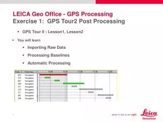
Leica Geo Office Importing GNSS Data • SmartWorx raw data /Rinex data
Leica Geo Office Intervals • When importing GPS data a point triplet Navigated or Measured is connected to each interval (depending if it is RTK or raw data) • Deleting an Interval will automatically remove the measured triplet, the observation and as well the GPS raw data from the project • You can re-assign an interval to a new or existing Point EID
Leica Geo Office Intervals • Intervals are specific for GPS • To view the properties->right click on a point in GPS Proc tabbed view • An Interval represents the occupation of a point with GPS instrument • It has a START and END time
Leica Geo Office Point Classes The following coordinate classes are available • Estimated (can be manually entered) • Navigated • SPP • Measured • Average (created automatically when more than 1 measuered triplet available) • Reference • Adjusted • Control (can be manually entered)
Baseline Vector A B Leica Geo Office What is baseline Processing? • Baseline processing implies the computation of a 3-dimensional vector between two occupied sites • Observations collected at two stations, at the same time, and to the same satellites are combined during processing
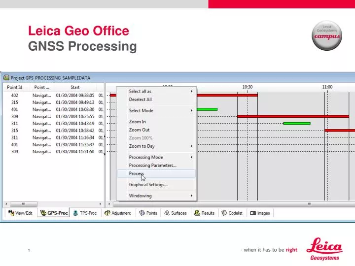
Leica Geo Office GPSProcessing in LGO • The GPS Processing may be accessed via the GPS –proc Tab within a project • The GPS Processing consists of two major parts • Selection of Observations (supported by the graphical Selection Mechanism) and selection of GPS processing Parameters • Processing itself
Leica Geo Office Processing Modes • LGO offers two Processing Modes: • Manual • Automatic
Leica Geo Office Manual Mode • If the user selects the manual mode, he can configure how the data is computed • Baseline Processing and Single Point Positioning is possible • Baseline processing implies the computation of a 3-dimensional vector between two occupied sites. • One station has to be assigned as reference site, the other as rover • A baseline computation yields the three-dimensional coordinate differences of the roving station relative to the reference station, in the WGS84 coordinate system.
Leica Geo Office Manual Mode Single Point Positioning (SPP) • Single point positioning uses code measurements collected at a single station during one or more occupations • A single point position computation yields absolute station coordinates in the WGS84 coordinate system.
Leica Geo Office Processing Parameters Auto Processing • Only few mouse clicks are needed to process the data • The baselines are processed in an order which would most likely be chosen by manual processing • It will intelligently select the reference and rover stations and process all possible combinations of baselines that conform to the set parameters.
Leica Geo Office Processing Results • After the GPS Processing is completed the results can be viewed using the Results View • After inspection of the data processing results you may select individual or all baselines and store them in the Project database.
Leica Geo Office Observations • LGO project stores the GPS observations • Observations can be GPS baseline vectors (Dx,Dy,Dz) from RTK or post processing • Observations always starts at Reference triplet and end at Measured triplet
Leica Geo Office Observations • When an observation is created the Reference and Measured triplets are also created automatically, this happens when you store processing results • If you Delete the GPS observation (baseline vector) the Ref and Measured triplet will be deleted as well but not GPS raw data
Leica Geo Office Undo Processing Results • Imagine you want to undo all of your GPS-Processing runs in a pure GPS project • Press CTRL-A in the View/Edit tabbed view to select all points and observations in the project • Select Delete followed by Observations.
Leica Geo Office Satelite Availability • The Satellite Availability tool helps you to plan your GPS field work. • It provides you with graphical and numerical information on the satellite constellation for any location (Site) at a given time
Leica Geo Office Satelite Availability • To compute the satellite availability for a specific Site, Almanac information has to be provided. • During the import of GPS raw data, almanac files are automatically stored into the Office database • Almanacs can also be imported manually
Antenna Management Phase Center Offset • A GPS baseline consists of the vector between the phase center of two GPS antennas. Each antenna type (brand, model) has it own phase center offset. This is especially noticeable if baselines are processed using mixed GPS antennas. • The phase center offset of different antennas varies especially in terms of a height difference between the L1 and L2 phase center. The difference in position usually is negligible
Antenna Management Phase Center Offset • The Antenna Management enables you to manage the phase center offsets for different GPS antennas. • The offsets are then applied as corrections during the baseline processing • All Leica antennas have been calibrated against the reference antenna and the relative offsets are already hardwired in the Office software. • If you are using Leica antennas only, the appropriate corrections are applied automatically and the user is not required to make any changes in the Antenna Management tool.
Antenna Management Phase Center Variations • A GPS antenna does not have a single well-defined phase center. Instead, the phase center is a function of the direction from which it receives a signal. This is known as the Phase Center Variation (PCV). • For highest accuracy the phase center variations can be defined using the Additional corrections. • Almost all GPS antennas currently in use are azimuthally symmetric to a high degree, however azimuth dependency can also be modeled. • The parameters for the phase center variation may be described using two different models - using Elevation and Azimuth or Spherical harmonics. If either model type was selected on the General antenna page, you can display or edit the additional corrections.
Antenna Management Antenna Type • Normally, the antenna type is set on the receiver in the field. • If you download GPS raw data, the appropriate antenna type is also downloaded to the project. • Set the new antenna type using the Interval Properties of the Data Processing View.
Leica Geo Office Antennas View • If you want to assign a different antenna type to your GPS raw data Drag and Drop the appropriate antenna type from the Antenna Management to the Antennas View of the Project
Leica Geo Office Precise Ephemeris • Precise Ephemeris are imported directly into the database and can be used by different projects without being bound to one special project. • Tools – Precise Ephemeris Management
Leica Geo Office Precise Ephemeris • Import
Leica Geo Office Internet Download • Internet download • Availability of more than 1300 reference stations world-wide • Download RINEX data, precise ephemeris(~13d) or rapid orbits(~17h) • Filter option for site selection, i.e. select what you need ! • Download Import Post-Process … • Comprehensive and easy to use.
Leica Geo Office Internet Download • Configure the Internet Download in TOOLS/OPTIONS/INTERNET • Filter option for site selection • Choose between Manual or Automatic mode
Leica Geo Office Processing Parameters Which parameters or combination of parameters to select for different observation scenarios? • System Default and Automatic parameters should initially be used to process data • The PSI-Pro is designed to internally select the best set of parameters to provide optimal results
Leica Geo Office Processing Parameters General • Cut off angle • Ephemeries • Solution Type: • Automatic (Default), … ‘use best possible combination’ • Phase: all fix • Phase: GPS fix, GLONASS float • This is recommended when mixingGLONASS data from differentmanufacturers to avoid additional biases. • Code • Float Most baselines will be successfully processed using the default parameters !
Leica Geo Office Processing Parameters Strategy page • Frequency: Automatic (Default), … ‘best possible combination of frequencies’ • Fix ambiguities up to:Above this limit, no attempt to fix ambiguities • Ionospheric model:Automatic (Default), … use best possible Ionospheric model • Find additional information inside the embedded help system of LGO! There is no need to change the default settings … Intelligence is built-in.
Leica Geo Office Processing Parameters Strategy page Frequency: • Automatic: (Default) • L3 solution if dual frequency data and baseline > 15 km • If ambiguities resolved an ionospheric free solution (L3) is introduced. • If ambiguities not resolved an L3 float solution is computed. • If baseline < 15 km an L1+L2 solution is computed. • L1/E1 or L2: • This particular frequency will be used for computing the solution. • L1+L2: • Force the computation to use both frequencies L1 and L2 without a second iono-free processing run independent of the baseline length. • Iono free (L3): • compute an L3 solution independent of the baseline length
Leica Geo Office Processing Parameters Strategy page Fix ambiguities up to: • 80 km (Default) • Maximum distance of baselines to resolve ambiguities. • For baselines above the limit a float solution will be computed. Min. duration for float solution (static): • Minimum time which allows the computation of a float solution for static intervals. • For short observation times float solutions may not be accurate enough and a simple code solution may be preferable. • Automatic switch to code-only solution in case ambiguities cannot be resolved for periods shorter than 300 seconds (for example). Sampling Rate: • The user can specify how much of the recorded data to use in GPS processing
Leica Geo Office Processing Parameters Strategy page Troposheric Model: • Part of the atmosphere up to a height of about 30 kilometres. • Causes delay in the propagation of electromagneticwaves such as those used in GPS. • Differences from using different models are small (a few millimetres). • Various models exist (all based on information regarding pressure, temperature and relative humidity of the ground station) • It’s recommended to adopt the locally-used model for all computations. • ‘Hopfield’ is Default. • ’Computed’ is advised for longer baselines and baselines with a larger height difference. • In these cases tropospheric conditions are assumed to vary over the time or to be different on reference and rover. • Selecting the option ‘Computed’ will improve the height component of the processed baseline.
Leica Geo Office Processing Parameters Strategy page Ionospheric Model: • Surrounds the earth at altitudes between 100 to 10.000 km. • Causes signal path delay, which can sometimes amount to several tens of metres !! • The Ionospheric model parameter defines which model is used to reduce the impact of the ionosphere. This is of special importance if you try to resolve ambiguities. • ‘Automatic’ is Default. • The model to be used is depending on the observation times. • For observation times on the reference longer than 45 minutes the ‘Computed Model’ is used. • For shorter observation periods the ‘Klobuchar’ model will be preferred.
Leica Geo Office Processing Parameters Strategy page Ionospheric Model: • Computed model uses the raw data from the reference. • Requires at least 45 minutes of dual frequency static data. • If less than 45 minutes of data is available it’s automatically switched to ‘No model’. • Klobucharmodel is advantageous during times of high solar activity. This model should only be selected if data from LEICA GPS sensors is being used to process. • Data are contained in the almanach file from LEICA sensors. • If raw data has been imported via RINEX and the Klobuchar model is selected the processing automatically switches to ‘No model’. • No model implies low ionospheric activity. • With increasing ionospheric activity it might be better to select a different model. • The ionospheric activity follows an eleven years cycle with its last peak in 2002.
Leica Geo Office Processing Parameters Strategy page Ionospheric Model: • Global / Regional model uses a file in Bernese format. • Such files are computed on a daily basis. • They are available via an anonymousFTP account free of charge. • Address is FTP.UNIBE.CH (or 130.92.4.48) • User ID (name) is ‘anonymous’. Use your e-mailaddress as password. • Change to folder ‘aiub/CODE’. • Change to the directory of the required year. • Select the file you require. The naming convention is as follows: CODwwwwd.ION.z With ‘wwww’ being the GPS week and ‘d’ the day of the week (Sunday = 0, Monday = 1, etc.) • Copy the file into the directory of your project.
Leica Geo Office Processing Parameters Strategy page Use stochastic modelling: • Select if modelling of the ionosphere additionally by calculating the ionospheric impact for each epoch is required. • Stochastic modelling supports ambiguity resolution on medium and longer baselines (i.e. 15 km and longer). • Select if you suspect the ionosphere to be quiteactive. • It’s recommended to leave the default value at 8 km. With shorterbaselines the ionospheric influence is smaller and stochastic modelling not necessary. • It’s advisable to leave the ‘Ionospheric activity’ option to ‘Automatic’ to let the processing algorithms react based upon the baseline length. • Stochastic modelling is disabled if the solution type is set to: a) Code b) Float and Frequency set to Iono-Free (L3)
Leica Geo Office - GPS ProcessingThe Ionosphere • The Peak of the Ionospheric Activity • The activity of the ionosphere depends directly on the number of sunspots with a cycle of 11-years. In 2002 was such a peak. • A small global mean value does not necessarily indicate where no ionospheric disturbances have to be expected. • The generally likelihood of their occurrence is correlated with the solar cycle.
Leica Geo Office Processing Parameters Extended Output page • DOP values, Azimuth, Elevation: DOPs/Azimuth/Elevation can be displayed. • Residuals: Residuals can be displayed.
Leica Geo Office Processing Parameters Auto Processing • Only few mouse clicks are needed to process the data • The baselines are processed in an order which would most likely be chosen by manual processing • It will intelligently select the reference and rover stations and process all possible combinations of baselines that conform to the set parameters.
Leica Geo Office Processing Parameters • The Auto. Processing Parameters only apply if the Processing Mode has been set to Automatic. • There are 2 processing modes • If all baselines is selected LGO will process all possible combinations of baselines that conform to the previous two parameters • If independent set has been selected LGO will only process a set of independent baselines. Note that between n points which are measured at the same time only n-1 independent baselines exist.
Leica Geo Office Coordinate seeding strategy • Selecting distance means that the shortest baseline from the first reference point will be computed first. LGO then decides which is the next shortest baseline There are 2 processing • Selecting time means that the baseline with the longest common observation time will be computed first
Leica Geo Office Remember • LGO offers the highest reliability possible for GNSS processing for static and kinematic baselines • The processing kernel continuously monitors the ambiguity resolution. • This results in the best reliability achievable for GPS-processing. • Intelligence built in-per default always the best possible settings are automatically chosen Which parameters or combination of parameters to select for different observation scenarios? • System Default and Automatic parameters should initially be used to process data • The PSI-Pro is designed to internally select the best set of parameters to provide optimal results