Download
1 / 19
200 likes | 288 Vues
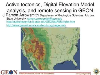
J Ramón Arrowsmith Department of Geological Sciences, Arizona State University, ramon.arrowsmith@asu.edu http://activetectonics.la.asu.edu/GEONatASU/index.htm http://www.geoinformaticsnetwork.org/swgeonet/ With Jeff Conner, Chris Crosby, and Gilead Wurman.

E N D
J RamónArrowsmithDepartment of Geological Sciences, Arizona State University, ramon.arrowsmith@asu.eduhttp://activetectonics.la.asu.edu/GEONatASU/index.htm http://www.geoinformaticsnetwork.org/swgeonet/ With Jeff Conner, Chris Crosby, and Gilead Wurman Active tectonics, Digital Elevation Model analysis, and remote sensing in GEONPI Meeting update www.geongrid.org
SCEC workshop SCEC CME/GEON Servlets ASTER satellite image processing (imsservlet) Lidar processing (lservlet) Visualization (gservlet) Logging (logservlet) Activities www.geongrid.org
SCEC-CME/GEON ties Workflow construction: Bertram and Yolanda are in touch, but the geoscience level is not as involved GIS (SCEC is weak there, but the community needs it) Resources in GEON are available as services; GMT vs. GIS. Could be good to have a goal for interoperability at AGU. ARCIMS gmt arcgrid ascii format send it the file and get a color image back. Shapefiles send to dynamic arcims session back. Base data for SOCAL. Visualization: LA3D/SCEC VIDEO spherical coordinate system with no fixed reference point Alpha stage; GEON is weak there USR. Vis workshop in January. Could tie with IDV guys for VIDEO. USR for the greater rockies. How do we build a model for it? What are the difficulties? Should extrude the QFAULTS data PHIL: Can we put the systems together in a some way for the geological geophysical communities: look at the strengths CIG - code CME - models GEON – data Earthscope – has all the data flowing Meta system that takes advantage of all of the projects. Issue of open source: companies have scec or geon buy a site license? User community has access to that software. Would publicize the software for a larger community. www.geongrid.org
LA3d www.geongrid.org
Java servlets on ASU GEON NODE lservlet imsservlet logservlet gservlet www.geongrid.org
Vs. webservice? Common technologies Load balancing (locally and on the grid) Portal implementation (local/main GEON) Servlet questions/issues www.geongrid.org
GRASS-based LiDAR processing webservice ~80,000 pts = 2.6 MB Subset of Airborne Laser Swath Mapping (ALSM aka LiDAR) data from Oct. 16, 1999 Hector Mine earthquake (Mw 7.1) mapping. www.geongrid.org
http://agassiz.la.asu.edu:8080/lservlet www.geongrid.org
lservlet job running on pop node ~ 5.5 minutes to run 80,000 pts. www.geongrid.org
Products: www.geongrid.org
full function lservlet page with user control over various interpolation parameters (by GSA) Jobs running on HP cluster at SDSC (by GSA??) Capability to ingest and interpolate data of various projections Enhanced functionality – hillshade etc. Coming soon: www.geongrid.org
http://agassiz.la.asu.edu:8080/gservlet www.geongrid.org
ASTER level-1B data have had system radiometric corrections and geometric coefficients applied and are reprojected to a given map projection. 1166 “granules” available http://aspen.asu.edu/website/Geoinformatics/viewer.htm http://www.geoinformaticsnetwork.org/swgeonet/ www.geongrid.org
ArcIMS, Java Servlet, Manager Program, Java Implemented Server Connection Method www.geongrid.org
http://agassiz.la.asu.edu:8080/logservlet Also needs to be there in the portal(s) Logging of activities www.geongrid.org
X-windows? Samba is running well Red Hat glibc libraries too old ARCIMS: Raster/grids support? Tomcat version 3 versus most-up-to-date version 4 on nodes (we have both running) Software/GEON Node issues-see forum posts www.geongrid.org