Download
1 / 18
180 likes | 310 Vues
Risk MAP Discovery Requirements Review and Overview of Watershed Flood Maps. Northwest Florida Water Management District Monday, August 22, 2011. Discovery.

E N D
Risk MAP Discovery Requirements Review and Overview of Watershed Flood Maps Northwest Florida Water Management District Monday, August 22, 2011
Discovery Discovery process requires data mining, collection, and analysis for initiating risk discussions within the watershed and determination of Risk MAP projects • Required for any potential Risk MAP project • When: • After an area/watershed has been prioritized and sequenced • Why: • Increases visibility of flood risk information, education, involvement • Promotes the idea of watershed concept • Helps inform whether a Risk MAP project will occur in the watershed • Discovery is flexible and scalable to the watershed under review
Watershed Stakeholder Coordination • Coordinate With Communities And Other Watershed Stakeholders
Data Analysis • Data analysis allows focused discussions on the goals and objectives of Risk MAP.
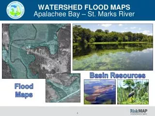
Discovery Map • Appendix I guidelines covers all the details of what we should include on the Discovery Map. • The Discovery Map will be finalized after the meeting and will be provided to the communities.
Discovery Report • A draft Discovery Report will be created using the data and information collected during Discovery and will be updated to include any new information obtained at the Discovery Meeting. • A final Discovery Report will be provided to the communities after the Discovery Meeting.
Project Determination • Project needs are identified by the water shed stakeholders. Once it is determined a flood risk project is appropriate, the final Discovery Report will be updated to reflect that decision. • At the time the decision is made whether to move forward with a flood risk project in the watershed, the project team must update FEMA databases.
Post-Meeting Coordination • The post-Discovery meeting coordination and communication must occur prior to initiating a flood risk project. • Coordination will be flexible and may occur in a number of ways.
Scope Refinement • Coordination with watershed stakeholders to • Refine scope including a decision about: • What regulatory and/or non-regulatory products may we provide? • What mitigation planning technical assistance that may we offer? • What communication and outreach assistance may we provide? • Finalize and deliver Discovery products (Discovery Map, Discovery Report) • Coordinate with communities with the objective to execute the project charter/MOU
Ochlockonee River Watershed Communities • The Ochlockonee River Watershed contains or touches: • 5 Florida counties: Gadsden, Leon, Liberty, Franklin, Wakulla • 7 Florida cities/towns: Quincy, Havana, Gretna, Greensboro, Midway, Tallahassee, Bristol, Sopchoppy • Estimated 2,423 total stream miles • 709 miles in Gadsden County • 317 miles in Leon County • 530 miles in Liberty County • 119 miles in Franklin County • 388 miles in Wakulla County • Approximately 95,000 residents within the watershed
Data Collection • Boundary, hydrography, and transportation layers • Lands in conservation including Federal and State • Elevation data (LiDAR) • Regional watershed plans • Previous flood hazard studies conducted • Repetitive loss data • Letters of Map Amendment and/or Letters of Map Revision • Average Annualized Loss (AAL) analysis – Level 1 • Parcel data • Census data • CNMS data • Hazard Mitigation Plans • Federal and State disaster information


![Flood Risk Review Meeting: [Watershed Name]](https://cdn1.slideserve.com/2624189/flood-risk-review-meeting-watershed-name-dt.jpg)
![Risk MAP and Discovery FEMA Region [#], [WATERSHED NAME] Watershed](https://cdn1.slideserve.com/2868558/risk-map-and-discovery-fema-region-watershed-name-watershed-dt.jpg)
![Flood Risk Review Meeting: [Watershed Name]](https://cdn2.slideserve.com/3807999/flood-risk-review-meeting-watershed-name-dt.jpg)