Download
1 / 1
10 likes | 106 Vues
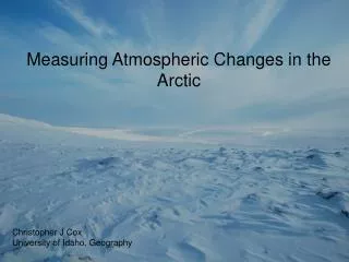
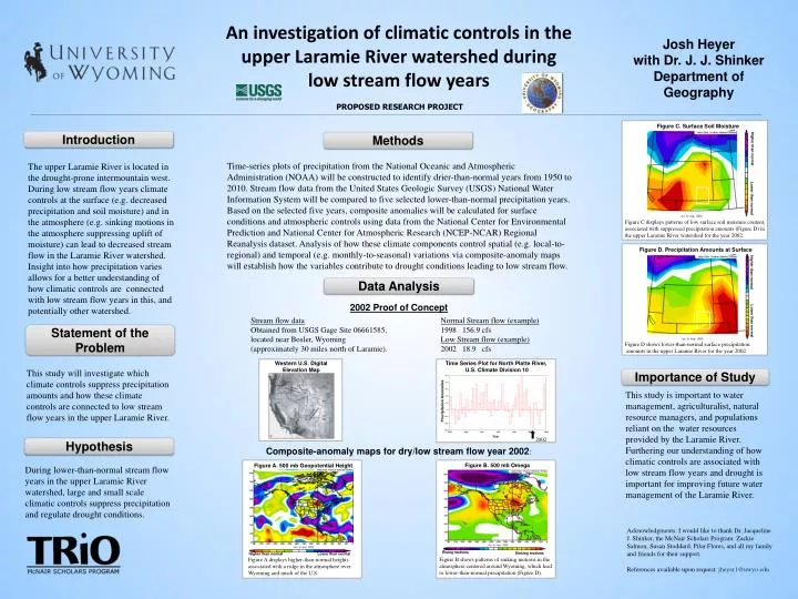
An investigation of climatic controls in the upper Laramie River watershed during low stream flow years. Josh Heyer with Dr. J. J. Shinker Department of Geography. PROPOSED RESEARCH PROJECT. Figure C. Surface Soil Moisture . Introduction. Methods. Higher than normal.

E N D
An investigation of climatic controls in the upper Laramie River watershed during low stream flow years Josh Heyerwith Dr. J. J. ShinkerDepartment of Geography PROPOSED RESEARCH PROJECT Figure C. Surface Soil Moisture Introduction Methods Higher than normal Time-series plots of precipitation from the National Oceanic and Atmospheric Administration (NOAA) will be constructed to identify drier-than-normal years from 1950 to 2010. Stream flow data from the United States Geologic Survey (USGS) National Water Information System will be compared to five selected lower-than-normal precipitation years. Based on the selected five years, composite anomalies will be calculated for surface conditions and atmospheric controls using data from the National Center for Environmental Prediction and National Center for Atmospheric Research (NCEP-NCAR) Regional Reanalysis dataset. Analysis of how these climate components control spatial (e.g. local-to-regional) and temporal (e.g. monthly-to-seasonal) variations via composite-anomaly maps will establish how the variables contribute to drought conditions leading to low stream flow. The upper Laramie River is located in the drought-prone intermountain west. During low stream flow years climate controls at the surface (e.g. decreased precipitation and soil moisture) and in the atmosphere (e.g. sinking motions in the atmosphere suppressing uplift of moisture) can lead to decreased stream flow in the Laramie River watershed. Insight into how precipitation varies allows for a better understanding of how climatic controls are connected with low stream flow years in this, and potentially other watershed. Lower than normal Figure C displays patterns of low surface soil moisture content, associated with suppressed precipitation amounts (Figure D) in the upper Laramie River watershed for the year 2002. Figure D. Precipitation Amounts at Surface Higher than normal Data Analysis 2002 Proof of Concept Stream flow data Obtained from USGS Gage Site 06661585, located near Bosler, Wyoming (approximately 30 miles north of Laramie). Normal Stream flow (example) 1998 156.9 cfs Low Stream flow (example) 2002 18.9 cfs Lower than normal Statement of the Problem Figure D shows lower-than-normal surface precipitation amounts in the upper Laramie River for the year 2002. Western U.S. Digital Elevation Map Time Series Plot for North Platte River, U.S. Climate Division 10 This study will investigate which climate controls suppress precipitation amounts and how these climate controls are connected to low stream flow years in the upper Laramie River. Importance of Study This study is important to water management, agriculturalist, natural resource managers, and populations reliant on the water resources provided by the Laramie River. Furthering our understanding of how climatic controls are associated with low stream flow years and drought is important for improving future water management of the Laramie River. Precipitation Anomalies Year 2002 Hypothesis Composite-anomaly maps for dry/low stream flow year 2002: Figure B. 500 mb Omega Figure A. 500 mb Geopotential Height During lower-than-normal stream flow years in the upper Laramie River watershed, large and small scale climatic controls suppress precipitation and regulate drought conditions. Acknowledgments: I would like to thank Dr. Jacqueline J. Shinker, the McNair Scholars Program: Zackie Salmon, Susan Stoddard, PilarFlores, and all my family and friends for their support. References available upon request: jheyer1@uwyo.edu Rising motions Sinking motions Lower than normal Higher than normal Figure B shows patterns of sinking motions in the atmosphere centered around Wyoming, which lead to lower-than-normal precipitation (Figure D). Figure A displays higher-than-normal heights associated with a ridge in the atmosphere over Wyoming and much of the U.S.