Download

1 / 23
230 likes | 236 Vues
Multi-scale Analysis and Prediction of the 8 May 2003 Oklahoma City Tornadic Supercell Storm Assimilating Radar and Surface Network Data using EnKF. Ting Lei 1 , Ming Xue 1,2 and Tianyou Yu 3 1 Center for Analysis and Prediction of Storms 2 School of Meteorology

E N D
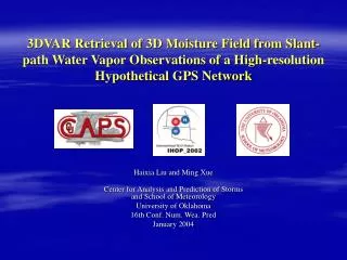
Multi-scale Analysis and Prediction of the 8 May 2003 Oklahoma City Tornadic Supercell Storm Assimilating Radar and Surface Network Data using EnKF Ting Lei1, Ming Xue1,2 and Tianyou Yu3 1Center for Analysis and Prediction of Storms 2School of Meteorology 3School of Electronic and Computing Engineering University of Oklahoma mxue@ou.edu January 13, 2009 Conf. of IOAS-AOLS, AMS Annual Meeting
Introduction The assimilation of simulated radar data using ensemble Kalman filter (EnKF) method for thunderstorm analysis and prediction has shown great promise (Snyder and Zhang 2003; Zhang et al. 2004; Tong and Xue 2005, etc.); The assimilation of real radar data for thunderstorm prediction has been much more challenging; No far, no published referred paper using EnKF exists that shows good thunderstorm forecast beyond 10 minutes
Existing Real Data Studies Dowell et al (2004, MWR) reported good EnKF analysis results for a supercell storm. No prediction was shown. Tong (2006) assimilated 1 or 2 WSR-88D radars for the 30 May 2004 OKC supercell storm. Forecasts were found to deteriorate beyond 30 min. Dowell and Wicker (2004) reported unsuccessful forecast following EnKF cycles for the 8 May 2003 OKC tornadic thunderstorm, while Dowell and Wicker (2009) present analysis results only on this same case. Interestingly, results obtained using simpler 3DVAR+cloud analysis system with the 8 May 2003 shows reasonable forecast (Hu and Xue 2007, 2008), even though the analyses were much less dynamically consistent.
Reasons for the Increased Challenge with Real Data Case Forecast model error (e.g., resolution, microphysics); Error in the storm-environment (not longer given by a perfect sounding); Data quality and coverage issues; Uncertainty about data error; Lack of truth/complete knowledge for verification/diagnostics; EnKF harder to tune (covariance inflation/localization).
Goal of This Study To obtain quality analysis and forecast for a tornadic supercell storm using EnKF and real data
Approach Assimilate multi-scale radar and conventional data (for storm-scale and storm environment); Nested grid EnKF; Mesoscale and storm-scale initial ensemble perturbations; Use 3DVAR to initial ensemble mean analyses; Analyzed data from multiple Doppler radars; Assimilate both radial velocity and reflectivity data; Use even higher-resolution for forecast; Verify against redar observations directly;
May 8, 2003 OKC Tornadic Supercell Storm OKC tornado 2210-2238 UTC 30 km long path F4 Tornado #1 2200 UTC 2204-2210 UTC
9 km/3 km/1 km DA cycles Fcst @ 1 and 0.5 km
3/1 km grids for EnKF DA ARPS 3DVAR+Cloud Analysis Forecast 2030 UTC 2140 UTC
Configurations • ARPS prediction model and 3DVAR • Lin microphysics • Land sfc model, sfc physics, radiation, 1.5-order TKE SGS turbulence • ARPS EnKF system based on EnSRF • 50 vertical levels • 40 ensemble members • Perturbed-obs plus pseudo profiles+3DVAR for mesoscale enesemble perturbations for 3 km grid • Additional smoothed random perturbations for 1 km storm-scale ensemble
Analyzed v.s. Observed ReflectivityMovies Projected to 0.48° elevation of KTLK Radar
Final 1 km EnKF Analysis @ surfaceGround-relative winds, reflectivity and vert. vorticity
Final 1 km EnKF Analysis @ z=2kmStorm-relative winds, reflectivity and w
Final 1 km EnKF Analysis @ z=4kmStorm-relative winds, reflectivity and w
Final 1 km EnKF Analysis @ z=8kmStorm-relative winds, reflectivity and w
1 km Full-Domain Forecast Animation at z = 1 km( movie and link to be added)
500m Forecast v.s. Observed ReflectivityMovies Projected to 0.48° elevation of KTLK Radar
OKC TDWR v.s. 500m Grid 15-min Fcst(not to scale) The 1 degree tilt reflectivity from OKC TDWR radar at 2208 UTC, 8 May 2003. 500m forecast Z, Vort and Vectors at Z= 1km , 2210 UTC, 8 May 2003.
50-m Grid Forecast v.s. Observation(starting from cycled 3DVAR+cloud analysis results) Movie Forecast Low-level Reflectivity Observed Low-level Reflectivity (Hu and Xue 2007 NWP, Xue et al. 2007)
Summary • By assimilation both mesonet and radar data using EnKF on two nested grids, we were able to obtain an ensemble-mean analysis that gave good forecast of a tornadic supercell storm up to 1 hour; • The rotational characteristics and propagation speed and direction of the forecast match radar observation well; • Experiments indicate (not shown) that accurate analysis of the storm-ensemble as important as storm-scale analysis for the forecast • Ensemble perturbations introduced at both meso- and storm-scale helped maintain spread important for effective EnKF analysis • Our results represent the first successful thunderstorm forecast using EnKF assimilation of real radar data
Future Work • More systematic sensitivity experiments examining effects of sfc data, mesoscale environment and perturbations, storm-scale inflation, model resolution, microphysics; etc. • Quantitative verification of forecasts against sfc and radar data; • Tornado-resolving resolution forecasts/simulations; • Ensemble forecasts starting from EnKF analyses.