Download
1 / 1
20 likes | 142 Vues
ANALYZING THE SPILLWAY FAILURE OF THE MONTEDOGLIO DAM IN CENTRAL ITALY. 1 Research Institute for Geo-Hydrological Protection National Research Council. European Geosciences Union General Assembly 2012 Vienna, Austria, 22–27 April 2012. 2 Umbria Region Functional Centre Umbria Region.

E N D
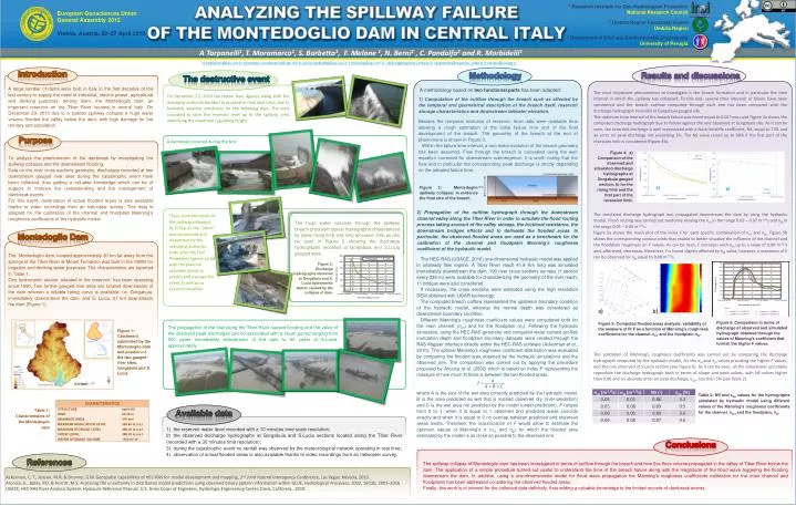
ANALYZING THE SPILLWAY FAILURE OF THE MONTEDOGLIO DAM IN CENTRAL ITALY 1 Research Institute for Geo-Hydrological Protection National Research Council European Geosciences Union General Assembly 2012 Vienna, Austria, 22–27 April 2012 2 Umbria Region Functional Centre Umbria Region 3 Department of Civil and Environmental Engineering University of Perugia A Tarpanelli1,T. Moramarco1, S. Barbetta1, F. Melone 1, N. Berni2 , C. Pandolfo2 and R. Morbidelli3 a.tarpanelli@irpi.cnr.it; tommaso.moramarco@irpi.cnr.it; silvia.barbetta@irpi.cnr.it; f.melone@irpi.cnr.it ; nberni@regione.umbria.it; cpandolfo@regione.umbria.it;renato@unipg.it Introduction Methodology Results and discussions The destructive event A large number of dams were built in Italy in the first decades of the last century to supply the need of industrial, electric power, agricultural and drinking purposes: among them, the Montedoglio dam, an important reservoir on the Tiber River located in central Italy. On December 29, 2010 due to a sudden spillway collapse a huge water volume flooded the valley below the dam, with high damage for the territory and population. A methodology based on two functional parts has been adopted: The most important phenomenon to investigate is the breach formation and in particular the time interval in which the spillway has collapsed. To this end, several time intervals of failure have been considered and the breach outflow computed through each one has been compared with the discharge hydrograph recorded at Gorgabuia gauged site. The optimum time interval of the breach failure was found equal to 0.02 hours and Figure 4a shows the computed discharge hydrograph due to failure against the one observed at Gorgabuia site. As it can be seen, the recorded discharge is well reproduced with a Nash-Sutcliffe coefficient, NS, equal to 73% and an error on peak discharge not exceeding 3%. The NS value raised up to 98% if the first part of the recession limb is considered (Figure 4b). The simulated discharge hydrograph was propagated downstream the dam by using the hydraulic model. Flood routing was carried out randomly varying the nch in the range 0.03 – 0.07 m-1/3s and nfp in the range 0.05 – 0.09 m-1/3s. Figure 5a shows the mesh plot of the index F for each specific combination of nch and nfp. Figure 5b shows the corresponding contour plots that enable to better visualize the influence of the channel and the floodplain roughness on F values. As can be seen, F increases with nch up to a value of 0.06 m-1/3s and, afterward, decreases. Moreover, F is found slightly affected by nfp value; however, a maximum of F can be observed for nfp equal to 0.08 m-1/3s. The validation of Manning's roughness coefficients was carried out by comparing the discharge hydrograph computed by the hydraulic model, for the nch and nfp values providing the higher F values, and the one observed at S.Lucia section (see Figure 6). As it can be seen, all the simulations accurately reproduce the discharge hydrograph both in terms of shape and peak values, with NS values higher than 0.86 and an absolute error on peak discharge, εQp, less than 5% (see Table 2). On December 23, 2010 the Italian Dam Agency along with the managing authority decided to proceed to final dam tests, due to favorable weather conditions for the following days. The tests consisted to raise the reservoir level up to the spillway crest identifying the maximum regulating height. 1) Computation of the outflow through the breach such as affected by the temporal and geometrical description of the breach itself, reservoir storage characteristics and downstream tailwater elevation. Besides the temporal evolution of reservoir, level data were available thus allowing a rough estimation of the initial failure time and of the final development of the breach. The geometry of the breach at the end of phenomena is shown in Figure 3. Within the failure time interval, a non-linear evolution of the breach geometry has been assumed. Flow through the breach is calculated using the weir equation corrected for downstream submergence. It is worth noting that the flow and in particular the corresponding peak discharge is strictly depending on the adopted failure time. Purpose Figure 4: a) Comparison of the observed and simulated discharge hydrographs at Gorgabuia gauged section; b) for the rising limb and the first part of the recession limb. To analyze the phenomenon of the dambreak by investigating the spillway collapse and the downstream flooding. Data on the river cross sections geometry, discharges recorded at two downstream gauged river sites during the catastrophic event have been collected, thus getting a valuable knowledge which can be of support to improve the understanding and the management of dambreak events. For this event, observation of actual flooded areas is also available thanks to video recordings from an helicopter survey. This data is adopted for the calibration of the channel and floodplain Manning’s roughness coefficients of the hydraulic model. A dambreak occurred during the test. Figure 3: Montedoglio spillway collapse: in evidence the final size of the breach. b) a) 2) Propagation of the outflow hydrograph through the downstream channel/valley along the Tiber River in order to simulate the flood routing process taking account of the valley storage, the frictional resistance, the downstream bridges effects and to delineate the flooded areas. In particular, the observed flooded areas are used as a benchmark for the calibration of the channel and floodplain Manning’s roughness coefficient of the hydraulic model. The HEC-RAS (USACE, 2010) one-dimensional hydraulic model was applied in unsteady flow regime. A Tiber River reach 41.8 Km long was simulated immediately downstream the dam. 190 river cross sections surveys (1 section every 235 m) were available for characterizing the geometry of the river reach; 11 bridges were also considered. If necessary, the cross sections were extended using the high resolution DEM obtained with LIDAR technology. The computed breach outflow represented the upstream boundary condition of the hydraulic model, whereas the normal depth was considered as downstream boundary condition. Different Manning’s roughness coefficient values were considered both for the main channel (nch) and for the floodplain (nfl). Following the hydraulic simulation, using the HEC-RAS geometry and computed water surface profiles inundation depth and floodplain boundary datasets were created through the RAS Mapper interface directly within the HEC-RAS software (Ackerman et al., 2010). The optimal Manning’s roughness coefficient distribution was evaluated by comparing the flooded area obtained by the hydraulic simulations and the observed one. The comparison was carried out by applying the procedure proposed by Aronica et al. (2002) which is based on index F representing the measure of how much fit there is between the two flooded areas: where A is the size of the wet area correctly predicted by the hydraulic model, B is the area predicted as wet that is instead observed dry (over-prediction) and C is the wet area not predicted by the model (under-prediction). F ranges from 0 to 1, when it is equal to 1 observed and predicted areas coincide exactly and when it is equal to 0 no overlap between predicted and observed areas exists. Therefore, the maximization of F would allow to estimate the optimum values of Manning's n (nch and nfp) for which the flooded area estimated by the model is as close as possible to the observed one. Montedoglio Dam The Montedoglio dam, located approximately 30 km far away from the springs of the Tiber River at Mount Fumaiolo, was built in the 1980s for irrigation and drinking water purposes. The characteristics are reported in Table 1. One hydrometric station, situated in the reservoir, has been operating since 1990. Two further gauged river sites are located downstream of the dam wherein a reliable rating curve is available; i.e. Gorgabuia, immediately downstream the dam, and S. Lucia, 31 km downstream the dam (Figure 1). Three concrete blocks of the spillway collapsed. At 9:43 p.m. the “alarm” was announced and dispatched by the managing authority. Soon after the Civil Protection Agency acted with the planned activities aimed to predict and manage the event as well as to prevent casualties. The huge water volumes through the spillway breach produced typical hydrographs characterized by steep rising limb and long recession limb as can be seen in Figure 2 showing the discharge hydrographs recorded at Gorgabuia and S.Lucia gauged sites. a) b) Figure 2: Discharge hydrographs observed at Gorgabuia and S. Lucia hydrometric station caused by the collapse of dam. Figure 6: Comparison in terms of discharge of observed and simulated hydrograph obtained through the values of Manning's coefficient that furnish the higher F values. Figure 5: Computed flooded areas analysis: variability of the measure of fit F as a function of Manning's roughness coefficients for the channel nch, and the floodplain nfp. Figure 1: Catchment subtended by the Montedoglio dam and position of the two gauged river sites, Gorgabuia and S. Lucia. A F = A + B + C The propagation of the flow along the Tiber River caused flooding and the value of the observed peak discharges can be associated with a return period ranging from 500 years immediately downstream of the dam to 30 years at S.Lucia, approximately. Table 2: NS and εQp values for the hydrographs simulated by hydraulic model using different values of the Manning's roughness coefficients for the channel, nch, and the floodplain, nfp. Table 1: Characteristics of the Montedoglio dam Available data • the reservoir water level recorded with a 10 minutes time scale resolution; • the observed discharge hydrographs at Gorgabuia and S.Lucia sections located along the Tiber River (recorded with a 30 minutes time resolution); • during the catastrophic event no rainfall was observed by the meteorological network operating in real time; • observation of actual flooded areas is also available thanks to video recordings from an helicopter survey. Conclusions References The spillway collapse of Montedoglio dam has been investigated in terms of outflow through the breach and how this floos volume propagated in the valley of Tiber River below the dam. The application of a simple procedure turned out useful to understand the time of the breach failure along with the magnitude of the flood wave triggering the flooding downstream the dam. In addition, using a one-dimensionale model for flood wave propagation the Manning’s roughness coefficients calibration for the main channel and floodplains has been addressed considering the observed flooded areas. Finally, this work is of interest for the collected data definitely, thus adding a valuable knowledge to the limited records of dambreak events. Ackerman, C. T., Jensen, M.R. & Brunner, G.W. Geospatial capabilities of HEC-RAS for model development and mapping, 2nd Joint Federal Interagency Conference, Las Vegas, Nevada, 2010. Aronica, G., Bates, P.D. & Horritt, M.S. Assessing the uncertainty in distributed model predictions using observed binary pattern information within GLUE, Hydrological Processes, 2002, 16(10), 2001–2016. USACE, HEC-RAS River Analysis System, Hydraulic Reference Manual. U.S. Army Corps of Engineers, Hydrologic Engineering Center, Davis, California., 2010.