Download
1 / 54
540 likes | 701 Vues
Uncertainty Quantification in Flood Inundation Mapping. Venkatesh Merwade School of Civil Engineering, Purdue University. IUPUI Earth Sciences Colloquium, Apr 29, 2010. . Acknowledgements. Aaron Cook , MSE 2008, Now at CDM in Denver, CO.

E N D
Uncertainty Quantification in Flood Inundation Mapping Venkatesh Merwade School of Civil Engineering, Purdue University IUPUI Earth Sciences Colloquium, Apr 29, 2010.
Acknowledgements • Aaron Cook, MSE 2008, Now at CDM in Denver, CO. • Younghun Jung, PhD Student, School of Civil Engineering, Purdue University.
Overview • Flood inundation mapping process • National Flood Insurance Program • Objective, methods, and results from previous and ongoing work • Summary
Q t Flood Inundation Mapping (FIM) Qp Digital Elevation Model (DEM)
Need for FIM • FIM show extent of flooding expected over an area including roadways and buildings. • Assist state and local agencies during emergency operations • Flood Insurance Rate Map (FIRM) • The U.S. Congress established the National Flood Insurance Program in 1968 enabling property owners to purchase insurance against flood losses • Flood maps for 100-yr flow (1% flow)
More on NFIP • Early stage – subsidized flood insurance – 95,000 policies in 1972 • Mandatory Flood Insurance in 1973 – 1.2 million policies by 1977 • 1994 amendment – inventory assessment at least once every 5 years • 100,000 flood map panels in 19,200 communities (approx. 150,000 sq. mi. of floodplain areas)
Map Modernization Program • Initiated in 1997 • Level -1 upgrade for approximately 11,400 communities (upgrading maps, redelineation of floodplain boundaries, etc) • Level - 2 upgrade for 4,700 communities (Level - 1 + more studies) • New maps for 2,700 flood-prone communities. • Digital FIRM
Model Parameters! Flood Inundation Mapping Train • Hydrologic Modeling – Q • Hydraulic Modeling – WSE • Flood Inundation Mapping – Flood Map Hydrologic Modeling Hydraulic Modeling Flood Inundation Mapping Q WSE Soil Streamflow GIS Precipitation LU/LC Topography
Objectives • To investigate the effect of data, model parameters and GIS techniques on flood inundation maps • How error or uncertainty in data or model propagates through the flood inundation train
Study Areas Strouds Creek, Orange County, NC Brazos River, Fort Bend County, Texas 6.5 km long; w = 10m; v-shaped valley 62 km long; w = 150m; flat terrain
Data HEC-RAS Models and Topography 53 XS 55 XS (a) (b) (a) (b) (c) (d) (c) (d) Strouds Creek Brazos River (a) 30m DEM; (b) 10m DEM; (c) LIDAR; (d) Integrated Terrain
Interpolated Mesh Island 2 Island 1 Surveyed cross-sections Interpolated mesh Surveyed cross-sections Integrated Terrain + = LIDAR Interpolated Mesh Integrated Terrain
HEC-RAS Hydrologic Engineering Center – River Analysis System One-dimensional steady state simulation The energy equation is solved between cross sections to compute the water surface profile for steady gradually varied flow Models and Tools • FESWMS • Finite Element Surface Water Modeling System • Developed by the Federal Highway Administration • Solves two-dimensional depth-averaged surface water flow equation ArcGIS HEC-GeoRAS SMS
Q Estimation NFF equation Q100 = 745 DA0.625 Q100: 100-yr flow DA: drainage area in sq miles. (range 0.1 – 41) Standard error of prediction is in the range of -34% to 57% Q100 for Strouds Creek is 83.3 m3/s (error range: 53.3 m3/s and 130.7 m3/s)
Effect of Q100 bounds on WSE • NFF estimated flow of 83.3 m3/s • 64% of 83.3 m3/s (lower bound) • 156.5% of 83.3 m3/s(upper bound) Variations in WSE at one of the cross-sections in HEC-RAS resulting from variations in Q
Effect of topography • Effect of topography – 30m DEM, 10m DEM, LIDAR and Integrated Terrain • HEC-RAS • Usedifferent topographic datasetsto create HEC-RAS projects and delineate inundation • FESWMS • Use different topographic datasets to create finite element mesh and get inundation
Effect of topography on WSE • Six Topographic Datasets • 30m USGS DEM (T1), 10m USGS DEM (T2), LIDAR DEM (T3), and integrated version of each dataset (T4-T6)
Effect of topography on Flood Inundation Extent Strouds Creek Brazos River Inundation increases as DEM resolution decreases
Effect of Geometry • HEC-RAS • For each topographic dataset, changecross-section configurations • FESWMS • For each topographic dataset, changemesh resolution
Geometry Definitions Strouds (a) (b) (c) (d) Brazos (a) (b) (c) (d) (a) Original XS; (b) XS * 2; (c) XS * 3; (d) XS * 0.5
Effect of Geometry - HECRAS Strouds Creek Brazos River For Integrated DEM For Integrated DEM Original XS XS * 3 Trend with increasing and decreasing XS Trend with decreasing XS only
Mesh Resolution Strouds Creek Brazos River 10 ft 125 ft main channel 20 ft 250 ft main channel
Effect of Geometry - FESWMS Strouds Creek Brazos River 10 ft 125 ft 20 ft 250 ft Higher mesh resolution predicts slightly larger inundation Lower resolution mesh predicts slightly larger inundation
HECRAS and FESWMS Comparison Strouds Creek Brazos River FESWMS 125 HECRAS HEC-RAS FESWMS 10
Effects of Manning’s n on WSE (1) a mix of Manning’s n for channel (0.035 – 0.065) and over bank (0.08 – 0.15) (2) 0.035 for channel and 0.08 for over banks (lower bound) (3) 0.065 for channel and 0.15 for over banks (upper bound).
1.25m floodplain 1.75m floodplain DEM v/s TIN Floodplain for both 1.25m and 1.75m WSE A A A A 2.0m 1.75m 1.25m 1.0m Section A-A Section A-A
Summary • Uncertainty is associated with all inputs and processes involved in flood inundation mapping • Currently a flood map derived by using any approach is considered as “The Map” for a particular area • A single line defines who is in the flooding zone and who is not • How much confidence do we have in our approach and flood maps?
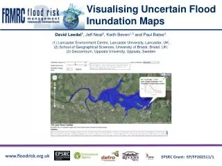
Where do we go from here? Probabilistic Flood Inundation Maps
Objectives • To investigate the effect of data, model parameters and GIS techniques on flood inundation maps • How to quantify uncertainty and its propagation through the flood inundation train
Approach • HEC-RAS Modeling • Monte Carlo Simulations to study the effect of: • Flow • Topography and • Channel Roughness (Manning’n) • Generalized Likelihood Uncertainty Estimate (GLUE)
GLUE O1 O2 ... … … O1000 l1 l2 ... … … l1000 R1 R2 ... … … R1000 Acceptable HEC-RAS 1000 p Unacceptable Manning’s n Input Model Output Likelihood (l) Ranked l R1 R2 ... … … R750 0.00 0.01 0.04 … … 1.00 50% gives the deterministic model output 5% and 95% give the associated uncertainty 95% 50% P 5% Output Behavioral Models Rescaled Output CDF
Likelihood functions W1 W2 E1 E2 F
Approach • HEC-RAS Modeling • Monte Carlo Simulations to study the effect of: • Flow • Topography and • Channel Roughness (Manning’n) • Generalized Likelihood Uncertainty Estimate (GLUE)
Study Area East Fork of White River near Seymour in Jackson county, IN (100 km south of Indianapolis).
Probability Distribution for Streamflow • Regression equation is developed • Observed flow rate is 2730 m3/s with a 95% confidence interval of 2257 m3/s and 3301 m3/s • Flow rate is randomly selected from a t-distribution within 2257 – 3301 m3/s range
Probability Distribution for Elevation • A vertical error of ± 0.25 is assumed for topography • A uniform distribution is assumed and a random number between ± 0.25 is added to each cross-section
Probability Distribution for Roughness • Uniform distribution is used by getting minimum and maximum values from literature
Summary and Future Work • Uncertainty from each variable in floodplain mapping can be quantifiable • Initial results show that the uncertainty from each variable propagates through the entire process • Uncertainty bound is affected by the technique used and its parameters • How does the uncertainty bound change with topography, geography and other environmental settings?
Some historical perspective • Eve: lets go for vacation • Adam: where do you want to go? • Eve: How about Orange County? • Adam: According to the soil map, orange county is in a flood zone. Lets go to Apple Town • Eve: Apple town sounds great! .. and then you know what happened…
Present Scenario • Jane: lets go for vacation • Joe: where do you want to go? • Jane: How about Orange County • Joe: I just booked beach home by going to waterhomes.com. • Jane: Excellent! Did you buy flood insurance? • Joe: Oh, I forgot, let me go to FEMA.gov
Flood Map for Tippecanoe County, IN FEMA SSURGO