Download
1 / 9
90 likes | 239 Vues
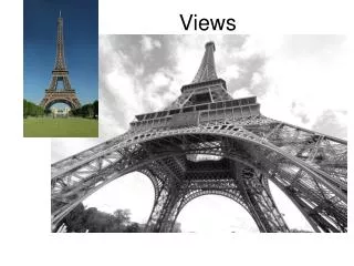
Views of Earth. Hey what does the planet look like. Landforms. There are three main landforms and several minor landforms that we will be studying. Plains Coastal Plains Interior Plains Plateaus Mountains Folded Mountains Unwarped Mountains Fault-Block Mountains Volcanic Mountains.

E N D
Views of Earth Hey what does the planet look like.
Landforms • There are three main landforms and several minor landforms that we will be studying. • Plains • Coastal Plains • Interior Plains • Plateaus • Mountains • Folded Mountains • Unwarped Mountains • Fault-Block Mountains • Volcanic Mountains
Plains • Plains are large, flat areas often found in the interior of continents. When plains are found near the ocean they are called coastal plains. • Coastal Plains – A coastal plain is called a lowland because it is lower in elevation (the distance above sea level) than the land around it. • An example in the United States is the Atlantic Coastal Plain • How is a coastal plain formed? • Interior Plains – consist of nearly horizontal layers of sedimentary rock.
Plateaus • Plateaus are raised, flat areas of land made of nearly horizontal layers of rock that have been uplifted by forces in the Earth. They are different from plains in that their edges rise steeply around them. • An example of this is the Colorado Plateau in which the Grand Canyon is located.
Mountains • Mountains tower high above the surrounding land. There are four main types of mountains. • Folded Mountains – Comprised of folded rock layers, squished together. • UnwarpedMountains – formed from blocks of Earth pushed up by forces inside the Earth. • Fault-Block Mountains – huge, tilted blocks of rock that are separated from surrounding rock by faults. • Volcanic Mountains – forms from molten material that reaches the surface of the Earth.
Viewpoints • What are latitude and longitude? • Start at the equator (the imaginary band that encircles the Earth) draw circles up and down that are parallel to the equator until you reach the poles. These are latitude lines. • Start at the poles and draw circles that surround the globe spaced equidistantly. These are longitude lines. • Time zones are based on longitude lines around the Earth.
Maps • What are they?
More classwork • Please do the questions: Section 1 assessment page 161 problems 1-5, Section 2 assessment page 165 problems 1-5, Section 3 assessment page 172 1-5 (They will be due next class)