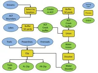
Download
1 / 35
370 likes | 712 Vues
Streams. Chapter 12 Water On and Under the Ground Geology Today Barbara W. Murck Brian J. Skinner. “Grand Canyon of the Yellowstone” Thomas Moran, 1872. N. Lindsley-Griffin, 1999. The Water Cycle.

E N D
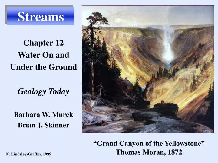
Streams Chapter 12 Water On and Under the Ground Geology Today Barbara W. Murck Brian J. Skinner “Grand Canyon of the Yellowstone” Thomas Moran, 1872 N. Lindsley-Griffin, 1999
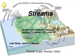
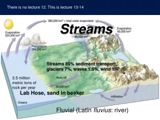
The Water Cycle Earth’s water cycle, the movement of water from one reservoir to another, is driven by solar energy and gravity Fig. 12.1 p. 328 N. Lindsley-Griffin, 1999
Water Reservoirs Most water is stored in the oceans (>97.5%) - all salty Only 2.5% is fresh water. Ice sheets store most of the fresh water - all frozen Fig. 12.3, p. 332 N. Lindsley-Griffin, 1999
Water Reservoirs Fig. 12.3, p. 332-33 Most of the unfrozen fresh water is groundwater, contained in pore spaces beneath Earth’s surface. Only a tiny fraction is surface water in streams and lakes. N. Lindsley-Griffin, 1999
Water Reservoirs The smallest reservoirs are: Soil moisture Water in mineral structures Atmospheric water Biosphere Fig. 12.3, p. 332-33 N. Lindsley-Griffin, 1999
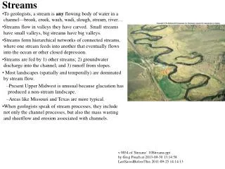
Stream Landforms Streams are most important for their ability to shape the landscape by erosion and deposition. Fig. 12.5, p. 335 Entrenched meanders - Colorado River Dead Horse Point, Utah N. Lindsley-Griffin, 1999
Relationship between mass wasting and streams…. Mass wasting provides a steady supply of sediment for streams to transport and deposit
Alluvium(stream sediment) Where deposited from high-energy streams: subangular to rounded and poorly sorted overall, although individual beds may be well sorted. Lower-energy streams: moderately to well sorted and rounded; finer grained Well layered; evidence of currents (crossbeds, troughs, ripples, graded beds) N. Lindsley-Griffin, 1999
Width Stream Discharge Depth Amount of water passing a point on the bank, per unit of time. Affected by: WIDTH of channel DEPTH of channel VELOCITY of flow Velocity Houghton-Mifflin, 1998; N. Lindsley-Griffin, 1999
Stream Discharge Channel dimensions (width, depth) increase downstream Velocity increases downstream Discharge increases downstream Houghton-Mifflin, 1998; N. Lindsley-Griffin, 1999
Stream Profile Cross section along a stream’s length: Concave-up Varies according to gradient or slope steepness Hudson River - high gradient Nile River - low gradient Houghton-Mifflin, 1998; N. Lindsley-Griffin, 1999
Base Level Elevation below which a stream cannot erode its channel Sea level is ultimate base level LOCAL BASE LEVELS: Lakes, dams, resistant ledges Houghton-Mifflin, 1998; N. Lindsley-Griffin, 1999
Stream Flow Maximum velocity - center Maximum turbulence - edges Laminar flow: Water moves in straight paths Turbulent flow: Water moves chaotically, causes suspension of particles and greatest erosion Houghton-Mifflin, 1998; N. Lindsley-Griffin, 1999
“Straight” Stream Channels Stream channels are never perfectly straight. Deepest water path curves from side to side. Fig. 12.6 p. 336 N. Lindsley-Griffin, 1999
Meandering Stream Channels As stream flow becomes more turbulent, the current begins to swing back and forth. Where current strikes bank, erosion is enhanced and stream meanders develop. Houghton-Mifflin, 1998; N. Lindsley-Griffin, 1999
Meandering Stream Channels Erosion is greatest on outer edges of bends. On inner edges, water slows down and deposits sediment. Fig. 12.6 p. 336 N. Lindsley-Griffin, 1999
Meandering Stream Channels Cut Bank Beal Slough - entrenched meanders, maximum erosion on outside of bend, deposition on inside of bend. Slumping Bar N.Lindsley-Griffin, W.J.Wayne, 1999
Meandering Stream Channels Meander cutoffs produce oxbow lakes Houghton-Mifflin, 1998; N. Lindsley-Griffin, 1999
Stream Landforms Floodplains consist of the relatively flat valley floor that is inundated when the stream overflows its banks. Houghton-Mifflin, 1998; N. Lindsley-Griffin, 1999
Stream Landforms Floodplain Valley widens by lateral erosion. Floodplain builds up by deposition Finest sediment is clay on floodplain or in oxbow lake. Point bars have coarser sediment (gravel, sand). Point bar Oxbow lake Erosional cutbank Fig. 12.7, p. 337 N. Lindsley-Griffin, 1999
Stream Channels A stream that is unable to move all the available sediment load deposits the sediment as bars to produce a braided stream. Fig. 12.6 p. 336 N. Lindsley-Griffin, 1999
Stream Deposits Braided streams have constantly shifting channels and bars, usually of sand and mud. Braided patterns form where discharge varies greatly and banks supply large amounts of easily eroded sediment. Bramaputra River Fig. 12.8, p. 338 N. Lindsley-Griffin, 1999
Stream Deposits Platte River - a braided stream. Sandhill Cranes and Whooping Cranes use the Platte River sandbars for safety at night USGS, , J.R. Griffin, N. Lindsley-Griffin, 1999 J.R. Griffin & N. Lindsley-Griffin, 1999
Stream Deposits Death Valley, California Note fault scarp Fig. 12.10 , p. 339 Alluvial fan - where the gradient of a stream decreases suddenly, it slows down and deposits its sediment load. N. Lindsley-Griffin, 1999
Fig. 12.9, p. 339 Stream Deposits Floodplains form where floodwaters spread out across the valley floor. As water leaves the channel, its capacity to carry sediment decreases sharply. Fine, fertile sediment settles out. Floodplain N. Lindsley-Griffin, 1999
Stream Deposits Natural levees form where floodwaters slow down and deposit sediment at the edge of the channel. Fig. 12.9, p. 339 Natural levees N. Lindsley-Griffin, 1999
Stream Deposits Delta - triangular deposit of sediment where a stream flows into standing water (ocean or lake) Nile River, entering Mediterranean Sea Fig. 12.11, p. 430 N. Lindsley-Griffin, 1999
Stream Deposits Over time, deltas build out into the standing body of water. Fine sediment is carried far out and deposited as “bottomset” beds. Most sediment is deposited as “foreset” beds at the steep delta front, which advances forward over the bottomset beds. “Topset” beds consist of fine sediment deposited on the delta surface during floods. N. Lindsley-Griffin, 1999
Drainage Basins Drainage basin - the total area from which water flows into a stream. Drainage divide - the topographic high that separates adjacent drainage basins. Fig. 12.13, p. 341 N. Lindsley-Griffin, 1999
Drainage Patterns Dendritic drainage patterns, characterized by tree-like branches, form on rocks that are relatively homogeneous. Fig. 12.15, p. 343 N. Lindsley-Griffin, 1999
Drainage Patterns Radial drainage patterns flow outward from a central high point. Fig. 12.15, p. 343 N. Lindsley-Griffin, 1999
Drainage Patterns Rectangular drainage patterns, characterized by sharp bends, form on jointed rocks. Fig. 12.15, p. 343 N. Lindsley-Griffin, 1999
Drainage Patterns Deranged drainage patterns are characterized by streams that appear or disappear suddenly, typical of karst regions. Fig. 12.15, p. 343 N. Lindsley-Griffin, 1999
Streams and Plate Tectonics A. 100 m.y. ago, the Amazon River flowed east to west. South America and Africa began to rift apart across Atlantic Ocean. B. 15 m.y. ago, subduction of the Nazca plate began. The Andes volcanic arc formed along western edge of South America. Amazon River drainage was blocked. C. Today, Amazon River flows from west to east. A B C © Houghton Mifflin 1998; N. Lindsley-Griffin, 1999
Streams of North America Major drainages of the U.S. and Canada. Mississippi River system drains the largest part of North America © Houghton Mifflin 1998.; N. Lindsley-Griffin, 1999