Download
1 / 50
520 likes | 705 Vues
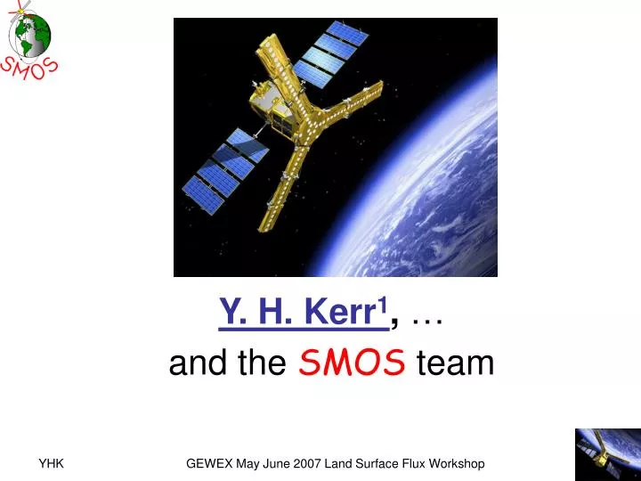
SMOS Soil moisture retrieval Algorithm. Y. H. Kerr 1 , … and the SMOS team. Outline. SMOS mission overview in a nutshell Soil moisture retrievals Level 2 Level 3 Level 4 Results, issues and next steps Conclusion. Science Objectives for SMOS : Salinity. Ocean salinity rationale.

E N D
SMOS Soil moisture retrieval Algorithm Y. H. Kerr1, … and theSMOSteam GEWEX May June 2007 Land Surface Flux Workshop
Outline • SMOS mission overview in a nutshell • Soil moisture retrievals • Level 2 • Level 3 • Level 4 • Results, issues and next steps • Conclusion GEWEX May June 2007 Land Surface Flux Workshop
Science Objectives for SMOS: Salinity Ocean salinity rationale • Thermohaline overturning circulation. • How can climate variations induce changes in the global ocean circulation? • Air-sea freshwater budget. • How are global precipitation, evaporation, and the cycling of water changing? • Tropical ocean and climate feedback Lagerloef et al., 2001 GEWEX May June 2007 Land Surface Flux Workshop
Science Objectives for SMOS: Soil Moisture • Role of Soil moisture in surface atmosphere interactions: • storage of water (surface and root zone), water uptake by vegetation (root zone), fluxes at the interface (evaporation), influence on run-off • Implies relevance for • Weather Forecasts • Climatic studies • Water resources • crop management • Forecast of extreme events • Climate change predictions and • rain event forecasts requires • SST and SM GEWEX May June 2007 Land Surface Flux Workshop
How to access soil moisture • Ground measurements • Networks (GEWEX) • SW, SWIR, …. • THIR…. • Low frequency microwaves • Active microwaves • Vegetation, roughness • Revisit • Sensitivity • Passive microwaves antenna issue GEWEX May June 2007 Land Surface Flux Workshop
Science Objectives for SMOS: The SMOS Mission SMOS is the second Earth Explorer opportunity mission (1st round) An ESA/CNES/CDTI project Selected in 1999, initiated in 2000 Phase B finished, C/D Started in January 2004 for a launch in 2008 A new technique (2D interferometry) to provide global measurements from space of key variables (SSS and SM) for the first time. Mission specifications Soil Moisture multi-angular dual pol 4 % vol 3 day revisit (Vegetation 7 day) better than 50 km • Need for soil moisture and sea surface salinity fields • Only passive L band suitable • Real aperture systems currently not adequate (antenna size) ==>Synthetic antenna Sea Surface Salinity multi acquisitions dual pol or 1st stokes better than 0.1 psu 10 day to monthly Grid scale (200 km) Pellarin et al Le Traon et al GEWEX May June 2007 Land Surface Flux Workshop
Space sampling requirement : every l/2 valueat least one time ; hence "thinning" possibilities. Interferometry • angular resolution provided by distant antennas • correlation products s(1)*s(2) visibility functions V(D/l) • Inverse F.T. on V TB(q) GEWEX May June 2007 Land Surface Flux Workshop
Principle of operations SMOS FOV; 755 km, 3x6, 33°, 0.875l, • Each integration time, (2.4 s) a full scene is acquired (dual or full pol) • Average resolution 43 km, global coverage • A given point of the surface is thus seen with several angles • Maximum time (equator) between two acquisitions 3 days P. Waldteufel, 2003 GEWEX May June 2007 Land Surface Flux Workshop
SMOS Baseline • 18+5 elements /arm configuration • Mean Altitude --> 757 km +/- 500 m • 30° steer angle • 32.5° tilt angle • Elements spacing 0.875 l • Dual or Full pol GEWEX May June 2007 Land Surface Flux Workshop
Payload Module (deployed) • SMOS Instrument: MIRAS derived concept • CASA EADS (Spain) • BUS: PROTEUS • Alcatel Space Industry • Launcher ROCKOT • Ground segment: Level 0-2 Villafranca • Level 3-4 Toulouse Payload Module (stowed) SMOS in Rockot Esa lead with contributions from France and Spain GEWEX May June 2007 Land Surface Flux Workshop CASA EADS, 2003
Schedule • Current: • Payload module is finished and under final testing • Antennas have been measured (TUD) • Ground segment at various stages depending levels • Delivery of PLM after testing mid 2007 • Level 1 Prototype operational end 2006 • Level 2 Breadboards-prototypes Mid 2007 • CATDS (Level 3 and 4) initiated end 2007 • Overall schedule • Launch 2008 • 6 months commissioning phase • 2.5 + 2 years operation • Cal val AO • Science use AO • Near Real Time • SMOSOps GEWEX May June 2007 Land Surface Flux Workshop
Hardware GEWEX May June 2007 Land Surface Flux Workshop
LEAF picture GEWEX May June 2007 Land Surface Flux Workshop
LSS picture GEWEX May June 2007 Land Surface Flux Workshop
Schedule • Current: • Payload module is being assembled (CASA) • Antennas are being measured (TUD) • Ground segment at various stages depending levels • Delivery of PLM after testing end of year • Level 1 Prototype operational end 2006 • Level 2 Breadboards-prototypes Mid 2007 • CATDS (Level 3 and 4) initiated end 2007 • Overall schedule • Launch 2008 • 6 months commissioning phase • 2.5 + 2 years operation • Cal val AO • Science use AO • Near Real Time • SMOSOps GEWEX May June 2007 Land Surface Flux Workshop
HUT Demonstrator Brightness temperature (K) measured by HUT-2D over densely forested forest areas surrounded by open field areas. Right: land use classification for the measured area. High brightness temperature areas correlate well with forest areas, and lower brightness temperature areas correlate well with open areas. The flight altitude is 1500 meters resulting in a ground resolution of approximately 100 x 100 meters. Juha Kainulainen, et al. 2006 GEWEX May June 2007 Land Surface Flux Workshop
Technical Elements Payload Data Processing Center Operations Data Flow – Open Loop Concept CATDS Centre Aval de Traitement des Données Smos(L3-L4) S-band ESL Expert Support Laboratory X-band Villafranca Kiruna USERS S/C & PL commands SC status & PLTM HKTM L3,L4 Reports XBAS X-Band Acqusition Station TTCET TM & TC Earth Terminal L0,L1,L2 Requests L2,L3,L4 S/C & PL commands TTCET commands Pass plans HKTM-P HKTM-R TTCET Monitoring Data Pass Plans IF PDPC Payload Data Processing Centre (LO-L2) ESOC SOCC Spacecraft Operations Control Center Calibration Data & PL status PL-HKTM, PL-TM, Pass plans & Orbit determination information GEWEX May June 2007 Land Surface Flux Workshop A. Hahne Estec
spatial Data products available will be: • Level 1: brightness temperature at H and V polarisation • Level 2: daily soil moisture and ocean salinity (swath) maps at basic temporal and resolutions • Level 3:daily global soil moisture mapsglobal salinity maps • Level 4:special products (root zone SM, SSS (Godae) fields, HYDROS / AQUARIUS / AMSR mix etc, • Other: Improved algorithms (level 1 and 2), and calibration, CalVAl • Services • All data products are produced (with quality statement) and distributed to registered users. • All data products are archived for the duration of the mission plus 10 years. • All data products are in a catalogue with a browse facility. Data products GEWEX May June 2007 Land Surface Flux Workshop
Aim and boundary conditions • Derive Soil moisture and Vegetation optical thickness (Water content) and …depending upon data available • Characterisation of angular signature (max up to over 100 measurements per pixels ( 10) down to a very few at the end of the swath) • Two polarisations every 3 days • Basic resolution 43 km on average (~25 to 50 km) • Higher spatial sampling 15 km typically (nodes) • Equal area projection • Blackman apodisation Weighting function/area • Many surface types per integration area /pixel elementary surfaces GEWEX May June 2007 Land Surface Flux Workshop
Models and mixed pixels Set of models fror each surface type GEWEX May June 2007 Land Surface Flux Workshop
30 0 10 20 40 50 Mean Soil Moisture (% volume): January 2003-2005 A Projection: EASE Grid Global; Datum: WGS-84 Teodosio Lacava – IMAA-CNR; GEWEX May June 2007 Land Surface Flux Workshop
30 0 10 20 40 50 Mean Soil Moisture (% volume): April 2003-2005 A Projection: EASE Grid Global; Datum: WGS-84 Teodosio Lacava – IMAA-CNR GEWEX May June 2007 Land Surface Flux Workshop
Level 2: Soil moisture Algorithm layout GEWEX May June 2007 Land Surface Flux Workshop
Issues: What is inside a pixel? • Decision tree set of models • Fixed features: • Low vegetation, forested, barren, water, permanent snow/ice, urban • Variable features • Snow, variable water bodies/ floods, frozen ground/ vegetation • Overlapping perturbing factors • Topography, RFI • Issues: • Knowledge • Temporal signatures GEWEX May June 2007 Land Surface Flux Workshop
External data GEWEX May June 2007 Land Surface Flux Workshop
The SMOS world….And DGGs… GEWEX May June 2007 Land Surface Flux Workshop
Pure pixels?... WA_DGG_exact Colour code/ ● ocean, ● inland water body, ● rivers, ● All others, ● WA_DGG_nowater; GEWEX May June 2007 Land Surface Flux Workshop
How homogeneous ? areas with prevailing nominal and forested aggregated LC fractions The land use map (MétéoFrance –Ecoclimap binned into generic classes) GEWEX May June 2007 Land Surface Flux Workshop
In conclusion: SM retrievals can be attempted in many areas with varying expected accuracy GEWEX May June 2007 Land Surface Flux Workshop
The Murrumbidgee Catchment Algorithm validation Plan • Need to validate the algorithm and the products: • Theoretical scenes, homogeneous, all over the swath, exact data acquisition, typical noise figure, exact geometry • Step in SM and vegetation opacity over the whole range C) Same analysis on realistic synthetic data sets Global and high resolution 15 days at several dates (solstices and equinox) D) Validation on ground data sets and then real sat data during commissioning phase SM retrieval performance with constrained TAU SM retrieval performance with free TAUSM GEWEX May June 2007 Land Surface Flux Workshop
Cal Val • Initiated (2005) • Teams selected (2005) • Optimisation process under way • Rely on CEOP whenever possible • GEWEX soil moisture network • Possibility to add sites • Work with modellers GEWEX May June 2007 Land Surface Flux Workshop
NAFE ’05 J Walker et al.Regional Data: 1km Elevation Visible GEWEX May June 2007 Land Surface Flux Workshop
1. EMIRAD calibration: Second ‘new’ calibration LAND THNADIR>TVNADIR by AVG=0.3 K, STD=0.9 K WATER THNADIR>TVNADIR by AVG=1.4 K, STD=1.8 K GEWEX May June 2007 Land Surface Flux Workshop 19/34 5
Issues • Water bodies • Varying features (Frozen, snow) • Perturbations (rain interception) • RFI • Unknown surfaces (urban, barren ….) • And things to discover…. GEWEX May June 2007 Land Surface Flux Workshop
AMSR DATA RFI at 6.8 (blue) and 10.7 (green) GEWEX May June 2007 Land Surface Flux Workshop
AMSR DATA RFI at 6.8 (blue) and 10.7 (green) GEWEX May June 2007 Land Surface Flux Workshop
Level 3 product • Basis : maximum possibilities: full resolution • Compatibility with other « products » • With well defined sampling on a fixed grid • Composite over well defined periods • Typical sampling • 1,3, 6-7, 10, 30days 1 year • 40 km, 1 ° • But updated daily in several cases • GODAE like • And tool boxes • Common format with other missions? • From ideally level 2 but actually L1 more likely GEWEX May June 2007 Land Surface Flux Workshop
Level 4 • Mainly research • Merged products (other existing missions) • Synergisms with future missions • Inter-calibration • Merge with models (run off, dis -aggregation, assimilation, Mercator etc…) • Stress on coastal areas, , Sea ice, Ice?, flooded areas, Catchments, flood /drought risks flags • Fire prone areas • Sky Map • Sun activity /tec • Non exhaustive list………. AQUARIUS Sea Surface Salinity Mission GEWEX May June 2007 Land Surface Flux Workshop
Calvet et al. Root Zone soil moisture PRINCIPLE OF THE ASSIMILATION OF REMOTE SENSING DATA Atmospheric Forcing (Rg, Ra, Ta, qa, U, P) Remote sensing Root-zone soil moisture SVAT model SURFACE Soil moisture Temperature Vegetation Optical thickness Radiative Transfer model Radiances Plant growth parameters or biomass Interactive Vegetation LAI Soil and vegetation parameters OPTIMISATION GEWEX May June 2007 Land Surface Flux Workshop
Data Assimilation ExperimentsM. Drusch ECMWF • CTRL OI (Optimum Interpolation) based on screen level analyses • for the top three model soil layers. • OL (Open Loop) without any soil moisture analysis. • NUDGE(Nudging) experiment using the TMI Pathfinder soil • moisture product. • Common features: • Full atmospheric 4DVar analysis using ~ 106 observations / 6h • (reflecting the operational configuration). • Model version CY29R1. • T511 spectral resolution, 60 vertical levels. • ‘Early delivery’ set up with 10-day forecasts from 00 and 12 UTC. • Study period from 1 June to 31 July 2002. GEWEX May June 2007 Land Surface Flux Workshop
Soil moisture increments (CTRL OI) Accumulated root zone soil moisture increments for June 2 to July 30, 2002. [mm] Analysis increments are a sizeable part of the terrestrial water budget. GEWEX May June 2007 Land Surface Flux Workshop
surface soil moisture root zone soil moisture • Too quick dry downs (model problem). • Too much precip in July (model problem). • Too little water added in wet conditions • (analysis problem). • NO water removed in dry conditions • (analysis problem). • Precipitation errors propagate to the • root zone. • Analysis constantly adds water. • The monthly trend is underestimated. model forecast (OI) model forecast (OI) model forecast (OL) model forecast (OL) observations observations area averages for Oklahoma (72 stations) Validation of soil moisture M Drusch The current analysis fails to produce more accurate soil moisture estimates. GEWEX May June 2007 Land Surface Flux Workshop
surface soil moisture root zone soil moisture • Nudging / satellite data remove water • effectively and produce a realistic dry • down. • Nudging the satellite results in the most • accurate surface soil moisture estimate. • The information introduced at the • surface propagates to the root zone. • The monthly trend is well reproduced • using the nudging scheme. area averages for Oklahoma Validation of soil moisture M Drusch Satellite derived soil moisture improves the soil moisture analysis and results in the most accurate estimate. GEWEX May June 2007 Land Surface Flux Workshop
SMOS pixel 40x40 km AVHRR Pixels TIR 1 km Pixel to pixel comparison Dis-aggregation • With use of higher resolution data (O. Merlin 2005) • Topo and vegetation+ SVAT model (J. Pellenq 2003) Measured SM (SGP ’97) Dis-aggregation Dis aggregated SM (O Merlin 2005) GEWEX May June 2007 Land Surface Flux Workshop
Conclusion • SMOS will be the first mission to deliver global fields of soil moisture and sea surface salinity • It is an EXPLORER Mission ==> new concept new instrument new measurements!! • The challenge NO data exists, NO Algorithm exists: we are breaking new grounds • Launch date 2008 - tomorrow! • Payload and Bus well underway • Ground segment started • Campaigns underway (CoSMOS NAFE and SSS, AMMA…) • Specific scientific activities (modelling, exotic targets, wiggles etc..) • Cal Val AO initiated • ( http//www.cesbio.ups-tlse.fr/us/indexsmos.html) • Issues: NRT, RFI • SMOS Ops GEWEX May June 2007 Land Surface Flux Workshop
Thank you …..Any questions ? http//www.cesbio.ups-tlse.fr/us/indexsmos.html GEWEX May June 2007 Land Surface Flux Workshop
LEWIS L band for Estimating Water In Soils High Quality Ground based radiometer 1.4 GHz, H & V sensitivity 0.1 K main lobe 12.5 @3db, 22° beam efficiency 0.986 No « visible » back lobes ONERA/CESBIO Operational since 23/1/2003 23 January 2003 GEWEX May June 2007 Land Surface Flux Workshop