Download
1 / 11
110 likes | 233 Vues
Update status of soil moisture algorithm. 2008.7.15 Joint AMSR Science Team Meeting, July 14-16, Telluride, CO. H.Fujii (JAXA/EORC) and T.Koike(UT). Defect of Koike's Algorithm.

E N D
Update status of soil moisture algorithm 2008.7.15 Joint AMSR Science Team Meeting, July 14-16, Telluride, CO H.Fujii (JAXA/EORC) and T.Koike(UT)
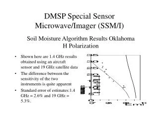
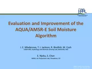
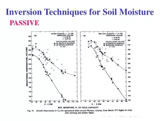
Defect of Koike's Algorithm "There are significant weaknesses in the JAXA product over vegetated sites" (T.J. Jackson, The GLI / AMSR workshop 2008 in Atami Japan, Jan.23,2008) Fig: Scatter plots of AMSR-E Monthly Soil moisture (y-axis) versus in-situ data (x-axis) at the Little River ,GA,USA monthly volumetric soil moisture in % 60 • Match-up • Data Period • January, 2003 -- December 2007 (60 months) • In-Situ: • data source: SCAN 2027 Little River, GA, U.S.A • sensor depth ; 5cm • sampling method: observed data which has closest timestamp to AMSR-E observation time within 1 hour • AMSR-E: • data source: JAXA product ver.5 Level2 • sampling method: closest FOV to the SCAN point within 5km range. AMSR-E 0 0 60 In-situ (SCAN2027, LR, 5cm depth)
Update log of Koike’s algorithm • March, 2004 : algorithm ver.3.01 (product ver.2-5) • Radiative transfer model for soil layer • Fractional vegetation cover , fc : TB= (1-fc)TBbare+ fcTBvege • March, 2008 : algorithm ver.5.11 (product ver.6) • Developing of the global data set of fractional vegetation cover,fc, (3 years average) from Terra/Aqua MODIS(LP DAAC). • Reconfiguration of vegetation parameter set , band w, based on the result of Ground Based Experiment. • Jun, 2008 : algorithm ver.5.33 (prototype product) • Expansion of data period of fcglobal data set ( Jun 2002 - May 2008) • Reconfiguration of roughness parameter set , Q and h
AMSR-E / In-situ data Ground Based Experiment using the Microwave Radiometer CEOP Mongolia Ref. Site Roughness parameter, Q-h Vegetation parameter b-w TBvege TBbare Radiative Transfer Model bare soil vegetated surface fc=1% Look-up Table fc=100% ・・・ Overview of Koike Algorithm Terra/Aqua MODIS Vegetation Indices (LP DAAC) MOD13A2/MYD13A2 (1km, 16days, v5) NDVI Global Data Set of fractional vegetation cover,fc Period: Jun 2002 – May 2008 Data size: 8 days, 0.05x0.05 grid Resolution: equivalent size to AMSR-E 10GHz FOV fc model: Carlson and replay, 1997 Soil Moisture Algorithm
AMSR-E Global Soil Moisture Map 6-yeas average of July (2002-2007) , Descending
Comparison of AMSR-E Soil Moisture and Precipitation map • AMSR-E Soil Moisture • L2, Descending • Volumetric Soil Moisture [%] • Precipitation : • Total amount of precipitation for 48 hours before AMSR-E observation. • Data source: GSMaP MVK hourly (JST-CREST/GSMaP )
(a) Gaize (b) B.Bolto (c) Little River Validation 1: Seasonal Changes of EVI in 2003 1.0 0.8 0.6 EVI 0.4 0.2 0.0 2003 Jan. Apr. Jul. Oct. • Gaize, Tibet, China. (CEOP)location: 32.30N, 84.05E • Balranald Bolto, NSW, Australira. (CEOP)location 34.658S, 143.549E • Little River, GA, USA. (SCAN, NRCS)location: 31.50N, 82.45W
(a) Gaize (b) B.Bolto (c) Little River Validation 1: New product (prototype) 1.0 0.8 0.6 EVI 0.4 0.2 0.0 60 Number of Data Des. 214 Asc. 200 (a) Tibet Gaize sensor depth 3cm (1.5 - 4.5cm) 30 40 0 60 0 Number of Data Des. 217 Asc. 223 20 (b) Balranald Boltosensor depth 0-7cm 30 40 0 Volumetric Soil Moisture [%] Daily Precipitation [ mm/day] 60 0 Number of Data Des. 200 Asc. 198 20 (c) Little Riversensor depth 5cm (3-7cm) 30 40 0 2003 Jan. Apr. Jul. Oct.
(a) Gaize (b) B.Bolto (c) Little River Validation 1: JAXA product (ver.5) 1.0 0.8 0.6 EVI 0.4 0.2 0.0 60 Number of Data Des. 93 Asc. 167 (a) Tibet Gaize sensor depth 3cm (1.5 - 4.5cm) 30 40 0 60 0 Number of Data Des. 206 Asc. 220 20 (b) Balranald Boltosensor depth 0-7cm 30 40 0 Volumetric Soil Moisture [%] Daily Precipitation [ mm/day] 60 0 Number of Data Des. 187 Asc. 184 20 (c) Little Riversensor depth 5cm (3-7cm) 30 40 0 2003 Jan. Apr. Jul. Oct.
60 60 (b) New Product (prototype) (a) JAXA product ver.5 50 50 40 40 AMSR-E AMSR-E 30 30 20 20 10 10 0 0 0 0 10 10 20 20 30 30 40 40 50 50 60 60 In-situ (SCAN 2027, LR, 5cm) In-situ (SCAN 2027, LR, 5cm) Validation 2: Monthly Soil Moisture at LR. Scatter plots of AMSR-E monthly averaged soil moisture(y-axis) versus in-situ data at Little River , GA in U.S.A.. The data period is from January 2003 to December 2007 (60 months). unit: volumetric soil moisture in %
Summary • The new global data set of fractional vegetation cover, fc, is introduced into the algorithm • The roughness parameter calibratedat Mongolia is used in the Ratiative Transfer Model. • The algorithm validated at Little River and the result showed that the accuracy was improved by comparing the old algorithms. Near future plan. • Masking method for uniformly and dense vegetated area. • Behavior of the algorithm in Sahara