Download
1 / 1
10 likes | 124 Vues
Depositional History of Unconsolidated Material. Physiographic Framework of the Willamette Lowland Aquifer System Prepared By: Ben Shivers ES 407 Environmental Geology. Natural Vegetation of Willamette Valley

E N D
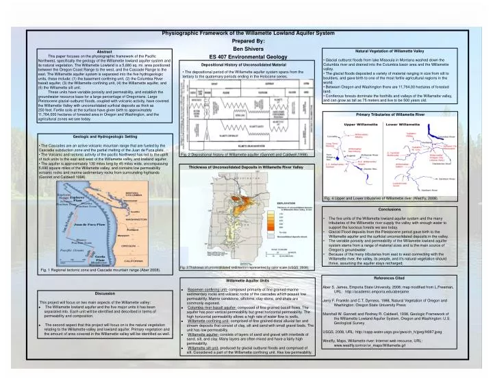
Depositional History of Unconsolidated Material Physiographic Framework of the Willamette Lowland Aquifer System Prepared By: Ben Shivers ES 407 Environmental Geology • Natural Vegetation of Willamette Valley • Glacial outburst floods from lake Missoula in Montana washed down the Columbia river and drained into the Columbia basin area and the Willamette valley. • The glacial floods deposited a variety of material ranging in size from silt to boulders, and gave birth to one of the most fertile agricultural regions in the world. • Between Oregon and Washington there are 11,764,00 hectares of forested land. • Coniferous forests dominate the foothills and valleys of the Willamette valley, and can grow as tall as 75 meters and live to be 500 years old. Abstract This paper focuses on the physiographic framework of the Pacific Northwest, specifically the geology of the Willamette lowland aquifer system and its natural vegetation. The Willamette Lowland is a 5,680 sq. mi. area positioned between the Oregon Coast Range to the west, and the Cascade Range to the east. The Willamette aquifer system is separated into the five hydrogeologic units, these include: (1) the basement confining unit, (2) the Columbia River basalt aquifer, (3) the Willamette confining unit, (4) the Willamette aquifer, and (5) the Willamette silt unit. These units have variable porosity and permeability, and establish the groundwater resource base for a large percentage of Oregonians. Large Pleistocene glacial-outburst floods, coupled with volcanic activity, have covered the Willamette Valley with unconsolidated surficial deposits as thick as 250 feet. Fertile soils at the surface have given birth to approximately 11,764,000 hectares of forested area in Oregon and Washington, and the agricultural zones we see today. • The depositional period of the Willamette aquifer system spans from the tertiary to the quaternary periods ending in the Holocene series. Primary Tributaries of Willamette River • Geologic and Hydrogeologic Setting • The Cascades are an active volcanic mountain range that are fueled by the Cascadia subduction zone and the partial melting of the Juan de Fuca plate. • The Volcanic and tectonic activity of the pacific Northwest has led to the uplift of rock units to the east and west of the Willamette valley and lowland aquifer. • The aquifer is approximately 130 miles long by 45 miles wide, encompassing 5,690 square miles of the Willamette valley, and contains low permeability volcanic rocks and marine sedimentary rocks from surrounding highlands (Gannet and Caldwell 1998). Fig. 2 Depositional history of Willamette aquifer (Gannett and Caldwell,1998). Thickness of Unconsolidated Deposits in Willamette River Valley Fig. 4 Upper and Lower tributaries of Willamette river (Westfly, 2008). • Conclusions • The five units of the Willamette lowland aquifer system and the many tributaries of the Willamette river supply the valley with enough water to support the luscious forests we see today. • Glacial Flood deposits from the Pleistocene period gave birth to the Willamette aquifer and the surficial unconsolidated deposits in the valley. • The variable porosity and permeability of the Willamette lowland aquifer system stems from a range of material sizes and is the main source of Oregon’s groundwater. • Because of the many tributaries from east to west connecting with the Willamette river, the valley, its people, and it’s natural vegetation should thrive, assuming the aquifer stays recharged. Fig. 3 Thickness of unconsolidated sediment in represented by color scale (USGS, 2008). Fig. 1 Regional tectonic zone and Cascade mountain range (Aber 2008). References Cited Aber S. James, Emporia State University, 2008; map modified from L.Freeman, URL: http://academic.emporia.edu/aberjame Jerry F. Franklin and C.T. Dyrness, 1988, Natural Vegetation of Oregon and Washington: Oregon State University Press Marshall W. Gannett and Rodney R. Caldwell, 1998, Geologic Framework of the Willamette Lowland Aquifer System, Oregon and Washington: U.S. Geological Survey. USGS, 2008, URL: http://capp.water.usgs.gov/gwa/ch_h/jpeg/H087.jpeg Westfly, Maps, Willamette river: Internet web resource, URL: www.westfly.com/or/or_maps/Willamette.gif • Willamette Aquifer Units • Basemen confining unit- composed primarily of fine grained marine sedimentary rocks and volcanic rocks of the cascades which posses low permeability. Marine sandstone, siltstone, clay-stone, and shale are commonly exposed. • Columbia river basalt aquifer- composed of fine grained basalt flows. The aquifer has poor vertical permeability but great horizontal permeability. The high horizontal permeability allows a high rate of water flow to wells. • Willamette confining unit- comprised of fine grained distal alluvial fan and stream deposits that consist of clay, silt and sand with small gravel beds. The unit has low permeability. • Willamette aquifer- consists of layers of sand and gravel with interbeds of sand, silt, and clay. Many layers are often mixed and have a fairly high permeability. • Willamette silt unit- produced by glacial outburst floods and comprised of silt. Considered a part of the Willamette confining unit. Has low permeability. • Discussion This project will focus on two main aspects of the Willamette valley: • The Willamette lowland aquifer and the five major units it has been separated into. Each unit will be identified and described in terms of permeability and composition. • The second aspect that this project will focus on is the natural vegetation relating to the Willamette valley and lowland aquifer. Primary vegetation and the amount of area covered in the Willamette valley will be identified as well.