Download
1 / 1
10 likes | 76 Vues
The Global Land Cover Facility. Successful Distribution and Development of Free Land Cover Products at the GLCF.

E N D
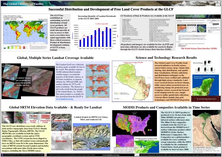
The Global Land Cover Facility Successful Distribution and Development of Free Land Cover Products at the GLCF The GLCF has established an outstanding record of distribution of land cover products. All GLCF products are made interoperable & easy to access so that users everywhere have equal opportunity with these critical resources. Product & distribution development continue at GLCF so keep looking! +13 Terabytes of Data & Products Are Available at the GLCF Increasing Quantity of Landsat Downloads at the GLCF 2003-2004 Unique TM and ETM+ Landsat Downloads at the GLCF by WRS-2 April 2003 – April 2004 Products Derived from Satellite Imagery Landsat Forest Change Products Landsat Paraguay Forest Change Landsat Amazon Basin Forest Change Landsat Central Africa Forest Change Landsat Mosaics Landsat Subsets Coastal Marsh Health Index GOES Radiative Fluxes MODIS Vegetation Continuous Fields (VCF) MODIS Vegetative Cover Conversion (VCC) MODIS Vegetation Index (NDVI) AVHRR Land Cover Classification AVHRR Tree Cover Continuous Fields AVHRR Global Production Effeciency Satellite Imagery Landsat MSS Landsat TM Landsat ETM+ Landsat GeoCover ASTER L1B Imagery MODIS 32-day Composites MODIS16-day Composites SRTM 30m Elevation Imagery SRTM 90m Elevation Imagery SRTM 1km Elevation Imagery Vector Products IUCN/UNEP Protected Areas Database Reference Layers 9.2 TB for August 2004 Megabytes All products and imagery are available for free via FTP, and most data collections are also available for search & display through the GLCF’s Earth Science Data Interface (ESDI). The Earth Science Data Interface (ESDI) Science and Technology Research Results Global, Multiple Series Landsat Coverage Available The Global Land Cover Facility leads research initiatives in Earth science, conservation science, large volume data sharing, data distribution, and spatial data visualization. All data collections and distribution techniques at the GLCF have been verified and validated through high science standards. Land cover research focuses on forest change, while conservation research focuses on monitoring change for protected areas. Computer science research has focused on developing tools for easy, simple access to online spatial data collections. Current efforts include data grid technologies and OPeNDAP integration. Paraguay Forest Change 1990-2000 Data Grid Design The Landsat GeoCover collection has been made available for free to the world. This product contains 24,000 orthorectified Landsat satellite images, covering the majority of the Earth's surface, at 30 meter resolution, in separate editions for 1990 and 2000, and another edition for 1975 at 80 meter resolution. The dataset is a gift to the world from the people of the United States, via NASA. The entire product is available for free download from the GLCF at www.landcover.org. 1973 MSS 2001 ETM+ 2000 ETM+ Coverage Protected Areas and Forest Cover over Yucatan, Mexico 3 Landsat Scenes are available for everywhere in the world, for free. 1990 TM Coverage 1990 TM 1975 MSS Coverage Red & Orange indicate forest loss Green & Green indicate forest remains The GLCF Develops Metrics Tools Global SRTM Elevation Data Available - & Ready for Landsat MODIS Products and Composites Available in Time Series The GLCF U.S. NDVI product is produced every 16 days from daily 250m MODIS red and near infrared surface reflectance data The 500m 32-day composites available from the GLCF are derived from the MODIS level 3 surface reflectance product called MOD09A1 (8-day Surface Reflectance Composites). The Composites are a global product – available for every continent except Antarctica, while the NDVI is available for the continental United States. Each product is available by interval since 2000. NDVI Landsat draped on SRTM over Lhasa, Tibet, and rendered 3-D. Landsat Draped on 90m DEM 90m DEM Landsat Scene GTOPO30 SRTM Coverage 90m SRTM Coverage The GLCF now distributes user-ready editions of land surface topography data from NASA’s Shuttle Radar Topography Mission (SRTM). The GLCF SRTM files are available in both the native geographic coordinate system and in UTM coordinates. The UTM version has been clipped to WRS-2 tiles, so that all Landsat scenes automatically have an SRTM scene fit to the same dimensions. The value of SRTM extends beyond Landsat and includes associations with most other Earth observation imagery, including the Terra MODIS sensor. MOD44B:Vegetation Continuous Fields MODIS Percent Tree Cover SRTM DEM 32-Day 500m MODIS Composites area global MODIS reflectance product with all seven bands. This product is available every 32 days since Terra was launched. (Above): This NDVI mosaic of South America was produced for the Large-scale Biosphere-Atmosphere (LBA) science community. It incorporates data from 6 MODIS tiles. www.landcover.org The GLCF is sponsored by NASA (CA NNG04GC53A) and the University of Maryland The GLCF is located in the University of Maryland Institute for Advanced Computer Studies (UMIACS) The GLCF is a founding member of the Federation of ESIPs, a member of the Open Geo-Spatial Consortium (OGC) and is a member of the World Conservation Union