Download
1 / 26
290 likes | 460 Vues
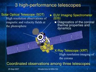
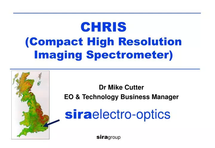
CHRIS (Compact High Resolution Imaging Spectrometer). Dr Mike Cutter EO & Technology Business Manager. sira electro-optics. sira group. CHRIS/PROBA – low cost mission. CHRIS Design concept - programmable hyperspectral Spectral range - VNIR Spatial sampling - 17 m @ perigee

E N D
CHRIS (Compact High Resolution Imaging Spectrometer) Dr Mike Cutter EO & Technology Business Manager siraelectro-optics siragroup
CHRIS/PROBA – low cost mission • CHRIS • Design concept - programmable hyperspectral • Spectral range - VNIR • Spatial sampling - 17 m @ perigee • PROBA Platform • Small satellite (100kg) – launched October 2001 • Agile 3-axis stabilised platform - roll, pitch & yaw • Provides multi-angle observations & motion compensation • Mission Objectives • Obtain selected land and littoral images • Obtain multi-view angle measurements (aerosols, BRDF) • Evaluate in-orbit performance - precursor mission
Scene Radiance Information The radiance field is at least 7 dimensional ( v, s ,, , x, y, t ) Spectral Information Temporal Information Angular (BRDF) Spatial Information
MVA Data from CHRIS/PROBA • PROBA: • Along-track: five angles per overpass: 0°, ±36°, ±55° @ ground MVA = Multi-View Angle
MVA data from CHRIS/PROBA Day n+y Day n Day n+x By rolling the satellite ± 25º in the across-track direction it is possible to image a fixed point on the Earth surface at different sensor view angles. MVA = Multi-View Angle
Information from MVA Image Left: Nadir-view, multispectral composite (0.5µm, 0.65 µm and 0.85 µm) showing wheat (red), bare soil (blue) and oil seed rape (white). Right: Multi-angle composites (nadir + two oblique angles) at recorded 0.5 µm, 0.65 µm and 0.85 µm, respectively.
Specification • Image area 13 km square @ perigee • Spatial sampling interval 17 m @ perigee • Spectral range (nominal) 415nm to 1050nm • Spectral resolution 1.25 to 11nm • Spectral/Spatial registration +/- 0.05 pixel • Gain stage 4 levels (albedo 0.5,1,2,4 levels) • Digitisation 12 bits • Signal-to-noise ratio 200 (@ 0.2 albedo, 17m, 10nm) • Data per (13x13 km2) image 16.4Mbytes • Mass/power < 14 kg/ 10 W primary power • Volume 790 x 260 x 200 mm3
Platform Aspects • Platform - ESA PROBA (Verhaert, Belgium) • Orbit 570- 730 km, sun-synch. (10.30am node) • Inclination 97.97º, • Repeat period 11 days • Dimensions 800mm x 600mm x 600mm • Power/mass < 100 W/100 kg • Pointing • Along-track 0 º, +/- 36º, +/-55º (@ ground) • Across-track +/-25º (@ ground) • Absolute pitch/roll/yaw < +/- 0.1º • Control of pitch/roll/yaw < +/- 0.015º/s (11% of imaging pitch rate) • Maximum pitch rate 0.7º/s • Down-link S-band: 1 Mbit/s (5 images/day) • Ground Station Redu, Belgium
Observation Programme • Programme defined by CHRIS Steering Group (UK, ESA) • AO issued by ESA in 2000 for first year mission. • Observations • 21 Core sites, 31 additional sites, 12 reserve sites • Approx. 60 PIs world wide • Observation modes (5 off) excluding calibration • Mode 1: Low resolution – aerosols, 62 bands • Mode 2: High resolution – water, 18 bands • Mode 3: High resolution – land, 18 bands • Mode 4: High resolution – chlorophyll, 18 bands • Mode 5: Half swath/high resolution – land, 37 bands • Observation logistics • Apply 48 hour cloud predictions to aid target selection • Details: WWW.PROBA-CHRIS.ORG.UK
Satellite Pitch Rates Spectral
Current Status • Platform Commissioning • Platform undergoing fine tuning wrt pointing • Platform processor intermittent issue being investigated • Reviewing options for improving operational approach • Instrument Commissioning • Instrument performance assessment on-going • Data processing being validated for each imaging mode • Wavelength calibration (O2 line) results being evaluated • Downlink • Platform commanding approach being refined. • Reviewing options for utilising a Kiruna (polar) downlink. • Data sets • Plan to issue sample data sets to PIs in August 2002
Acknowledgements • BNSC for partial funding of CHRIS • ESA for the launch opportunity, support for calibration activities, data processing, the planning tool and website. • Redu, ESOC (Belgium) for operational support • Verhaert (Belgium) for platform support • RSAC (UK) for preparation of the planning tool & jointly with ESSC the CHRIS website. • UK PIs: • Prof. Mike Barnsley (BRDF), Swansea University • Dr Jeff Settle (Aerosols), ESSC, Reading University • Dr Samantha Lavender (Coastal), Plymouth University
The End WWW.PROBA-CHRIS.ORG.UK