Download
1 / 15
150 likes | 242 Vues
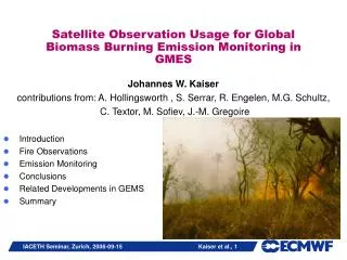
Observation Requirements for Global Biomass Burning Emission Monitoring. J.W. Kaiser 1 , M.G. Schultz 2 , J.−M. Gregoire 3 , C. Textor 4 , E. Bartholom é 3 , M. Leroy 5 , R. Engelen 1 , A. Hollingsworth 1 1 ECMWF, Reading, UK 2 FZ Jülich, Jülich, Germany 3 JRC, Ispra, Italy

E N D
Observation Requirements for Global Biomass Burning Emission Monitoring J.W. Kaiser 1, M.G. Schultz 2, J.−M. Gregoire 3, C. Textor 4 , E. Bartholomé3, M. Leroy 5 , R. Engelen 1, A. Hollingsworth 1 1 ECMWF, Reading, UK 2 FZ Jülich, Jülich, Germany 3 JRC, Ispra, Italy 4 CNRS, Paris, France 5 Medias-France, Toulouse, France
OUTLINE • Introduction • Atmosphere Monitoring • Land Monitoring • Observation System • Summary
INTRODUCTION: Biomass Burning (BB) in GMES • GMES aims at designing and establishing a European capacity for the provision and use of operational services for Global Monitoring of Environment and Security. • The FP6 IP GEMS develops the atmosphere monitoring system for GMES. • The FP6 IP GEOLAND develops the land monitoring system for GMES. • Biomass Burning (BB) is a major interface between both the atmosphere and land monitoring systems.
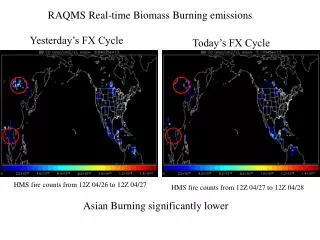
INTRODUCTION: Biomass Burning (BB) Emissions … AIR QUALITY: • … can dominate regional air quality in “severe air pollution” events • … can elevate background of atmospheric pollutant after long range transport [Stohl et al. 2001, Forster et al. 2001, Andreae et al. 2001] POLLUTION CONTROL: • … significantly contributes to global budgets of several gases • Kyoto, CLRTAP, … WEATHER: (absorbing aerosols) • … influences the radiative energy budget [Konzelmann et al., JGR 1996] • … provides cloud condensation nuclei [Andreae et al., Science 2004] • Heat release accelerates deep convection. [Damoah et al., ACP 2006] REMOTE SENSING: • … affects essential a priori information for remote sensing (AOD, profiles) CHALLENGE: • … are highly variable on all time scales from hours to decades NOAA, 2005-12-11
ATMOSPHERIC MONITORING: GEMS Objectives • global operational system for monitoring & forecasting atmospheric composition • global retrospective analyses 2000-2007 • several regional air-quality forecasting systems
ATMOS. MONITOR.: BB Observation Requirements • Product Types: • amount emitted: aerosol, trace gases • location • time • injection height profile • Availability: • global • ~25 km spatial resolution • several hours to one day time resolution • near-real time and retrospectively covering many years (>8a)
LAND MONITORING: Selected Objectives • to model vegetation as part of the global carbon cycle quantitatively • including carbon flux due to fire • to characterise behaviour of land cover types with repeated fire events • typical fire repeat period • typical fire intensity • typical fire seasonality • … • to monitor land cover change • partially due to fire, e.g. tropical deforestation
LAND MONITORING: Fire Product Requirements • Products: • amount of biomass burnt • type of vegetation burnt • date of fire • Availability • Global level products • 25x25km • consistent multi-year time series (>10a) • diurnal cycle • seasonal distribution • inter-annual changes
Two types of fire products accessible from Earth obs. systems • - Active fire • - Hot spot • Fire pixel • Fire count ACTIVE FIRE product Fire front BURNT AREA product - Burnt area - Burnt pixel - Burnt scar Area burnt OBSERVATIONS • thermal emission, MIR • only during fire • spectrally flat • BRDF flat • dark • only after fire
“pixels” burnt per vegetation type Area burnt per vegetation type: ha Fuel: T. ha-1 ???? M (…) = Area . Biomass . Burning efficiency. Emission factor Globe: ~ 400 millions hectaresburnt in 2000 Med. Basin: ~ 500000 hectares Woodland & forests ~ 1600 g CO2 / kg biomass Grasslands ~ 1700 g CO2 / kg biomass Dry tropical grass savanna: ~ 2 tons/hectare Moist tropical savanna: ~ 10 tons/hectare Boreal forest: ~ 20 tons/hectare Moist tropical forest: ~ 40 tons/hectare ~ 25% forest -- ~ 80% savanna OBSERVATIONS: Calculating Emission Amounts • traditional: • Fire Radiative Power (FRP): • M(…) = FRP * time * scaling factor * emission factor(…)
OBSERVATIONS: Existing Products (NRT) • Active Fire Products • yes/no-fire-product from: MODIS, AATSR (WFA), MSG, AVHRR (IGBP), TRMM-VIRS, SPOT-VGT (VGT2Africa) • quantitative from: GOES-E/W (WF-ABBA), MODIS (FRP) • Large fires may saturate MIR channel (~4μ). • Small fires are not detected. • Burnt Area from: AVHRR (GBA1992-1999), SPOT-VGT (GBA2000), AATSR (GLOBSCAR) • Accurate emission products often require small pixel sizes (~500m) and calibration with even smaller pixel sizes, e.g. BIRD.
Some Conclusions on Fire Products • No current product satisfies all requirements. • LEO spatial coverage/resolution complements GEO temporal resolution. • Hot spots (tropical forest) complement burnt area products. [C. Michel et al., JGR 2005] • need regionalised approach • Many existing products are inconsistent. [Boschetti et al. 2004] • Several new operational products are anticipated. • Fire Radiative Power from SEVIRI (M. Wooster) • WF_ABBA from global GEO system (E. Prins) • Burnt Area from MODIS (D. Roy) • Burnt Area from VEGETATION 2000-2006 (GDBAv1) • Burnt Area from GEOLAND (BAG)
PROPOSE: Global Fire Assimilation System (GFAS) • combining complementary satellite observations with land products and meteorology • single, consistent processing for all GMES systems • regionalised: events in mid-lat/boreal, statistics in tropics meteorology fire climatology GEMS greenhouse gases land cover climatology Global Fire Assimilation System reactive gases satellite fire product global fire emissions satellite radiance aerosols geoland, … land cover product carbon regional air quality fire product
SUMMARY • Biomass Burning (BB) emissions are needed globally in near-real time as well as in consistent multi-year time series. • No suitable BB emission product is available. Principal shortcomings are accuracy, delivery time, temporal resolution, geographical coverage. • Various fire observations complement each other. • We propose the development of a Global Fire Assimilation System (GFAS) to serve the GMES requirements. • Product generation needs to exploit existing observations more completely. • FRP is very promising due to accuracy of emitted amount calculation and temporal resolution.
MORE INFORMATION • www.ecmwf.int/research/EU_projects/HALO • www.ecmwf.int/research/EU_projects/GEMS • www.gmes-geoland.info • j.kaiser@ecmwf.int This work has been funded by the European Commission through the FP6 projects HALO, GEMS, and GEOLAND. ACKNOWLEDGMENTS THANK YOU!