Download
1 / 1
10 likes | 118 Vues
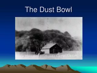
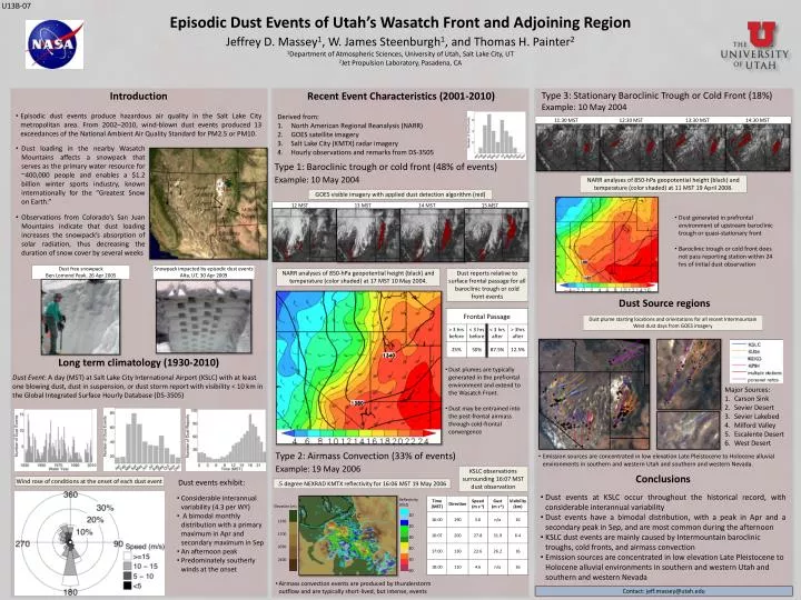
U13B-07. Episodic Dust Events of Utah’s Wasatch Front and Adjoining Region. Jeffrey D. Massey 1 , W. James Steenburgh 1 , and Thomas H. Painter 2 1 Department of Atmospheric Sciences, University of Utah, Salt Lake City, UT 2 Jet Propulsion Laboratory, Pasadena, CA. Introduction

E N D
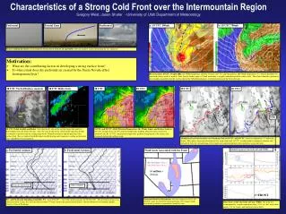
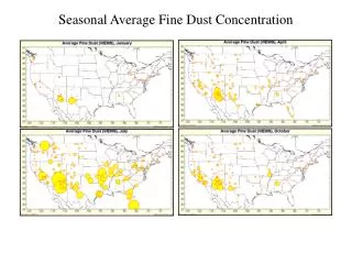
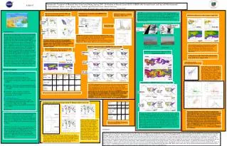
U13B-07 Episodic Dust Events of Utah’s Wasatch Front and Adjoining Region Jeffrey D. Massey1, W. James Steenburgh1, and Thomas H. Painter2 1Department of Atmospheric Sciences, University of Utah, Salt Lake City, UT 2Jet Propulsion Laboratory, Pasadena, CA • Introduction • Episodic dust events produce hazardous air quality in the Salt Lake City metropolitan area. From 2002–2010, wind-blown dust events produced 13 exceedances of the National Ambient Air Quality Standard for PM2.5 or PM10. Recent Event Characteristics (2001-2010) Type 3: Stationary Baroclinic Trough or Cold Front (18%) Example: 10 May 2004 Derived from: North American Regional Reanalysis (NARR) GOES satellite imagery Salt Lake City (KMTX) radar imagery Hourly observations and remarks from DS-3505 11:30 MST 12:30 MST 13:30 MST 14:30 MST • Dust loading in the nearby Wasatch Mountains affects a snowpack that serves as the primary water resource for ~400,000 people and enables a $1.2 billion winter sports industry, known internationally for the “Greatest Snow on Earth.” • Observations from Colorado’s San Juan Mountains indicate that dust loading increases the snowpack’s absorption of solar radiation, thus decreasing the duration of snow cover by several weeks Type 1: Baroclinic trough or cold front (48% of events) Example: 10 May 2004 Carson Sink NARR analyses of 850-hPa geopotential height (black) and temperature (color shaded) at 11 MST 19 April 2008. KSLC. Wasatch Mtns Sevier Lakebed GOES visible imagery with applied dust detection algorithm (red) Sevier Desert 12 MST 13 MST 14 MST 15 MST Milford Valley • Dust generated in prefrontal environment of upstream baroclinic trough or quasi-stationary front • Baroclinic trough or cold front does not pass reporting station within 24 hrs of initial dust observation Escalente Desert Dust free snowpack Ben Lomond Peak, 26 Apr 2005 Snowpack impacted by episodic dust events Alta, UT, 30 Apr 2009 NARR analyses of 850-hPa geopotential height (black) and temperature (color shaded) at 17 MST 10 May 2004. Dust reports relative to surface frontal passage for all baroclinic trough or cold front events Dust Source regions Dust plume starting locations and orientations for all recent Intermountain West dust days from GOES imagery Long term climatology (1930-2010) • Dust plumes are typically generated in the prefrontal environment and extend to the Wasatch Front. • Dust may be entrained into the post-frontal airmass through cold-frontal convergence Dust Event: A day (MST) at Salt Lake City International Airport (KSLC) with at least one blowing dust, dust in suspension, or dust storm report with visibility < 10 km in the Global Integrated Surface Hourly Database (DS-3505) Major Sources: Carson Sink Sevier Desert Sevier Lakebed Milford Valley Escalente Desert West Desert Type 2: Airmass Convection (33% of events) Example: 19 May 2006 • Emission sources are concentrated in low elevation Late Pleistocene to Holocene alluvial environments in southern and western Utah and southern and western Nevada. KSLC observations surrounding 16:07 MST dust observation • Conclusions • Dust events at KSLC occur throughout the historical record, with considerable interannual variability • Dust events have a bimodal distribution, with a peak in Apr and a secondary peak in Sep, and are most common during the afternoon • KSLC dust events are mainly caused by Intermountain baroclinic troughs, cold fronts, and airmass convection • Emission sources are concentrated in low elevation Late Pleistocene to Holocene alluvial environments in southern and western Utah and southern and western Nevada Wind rose of conditions at the onset of each dust event Dust events exhibit: .5 degree NEXRAD KMTX reflectivity for 16:06 MST 19 May 2006 • Considerable interannual variability (4.3 per WY) • A bimodal monthly distribution with a primary maximum in Apr and secondary maximum in Sep • An afternoon peak • Predominately southerly winds at the onset Reflectivity (DbZ) 10 20 30 40 50 60 Elevation (m) 1350 1700 2050 2400 KSLC • Airmass convection events are produced by thunderstorm outflow and are typically short-lived, but intense, events Contact: jeff.massey@utah.edu


![[Four Logos Here]](https://cdn1.slideserve.com/2626780/slide1-dt.jpg)