Download
1 / 1
10 likes | 85 Vues
A Review of Some Integrated Hydrologic Models. Marcel Giovanni Prieto Castellanos 1 and Eric Harmsen 2 1. Dept. of Civil Engineering, 2. Dept. of Agricultural and Biosystems Engineering University of Puerto Rico – Mayaguez Campus.

E N D
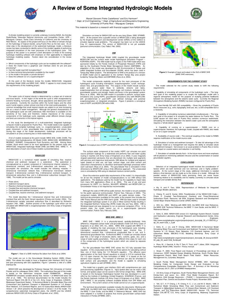
A Review of Some Integrated Hydrologic Models Marcel Giovanni Prieto Castellanos1 and Eric Harmsen2 1. Dept. of Civil Engineering, 2. Dept. of Agricultural and Biosystems Engineering University of Puerto Rico – Mayaguez Campus This material is based on a research with financial support from NASA-EPSCoR. • ABSTRACT • A climate modeling project is currently underway involving NASA, the Arecibo Radio/Radar Telescope National Astronomy and Ionosphere Center, UPR – Mayaguez Campus, Santa Clara University of California and the University of New Mexico. An aspect of this project will focus on the effect of climate change on the hydrology of tropical islands, using Puerto Rico as the test case. As an initial step in the development of the watershed hydrologic model, a literature review has been conducted to identify some of the models capable of performing integrated simulations of the main processes of the hydrological cycle. The purpose of this poster is to present a brief description of three of the existing hydrologic modeling software with emphasis on their applicability to integrated hydrologic modeling studies. Factors taken into consideration in the review included: • Which components of the hydrologic cycle can be modeled with the software? • Does the model have a graphical user interface (GUI) for pre and post processing? • Can the model read GIS formatted files? • Is there technical documentation available for the model? • Is the model in the public or private domain? • Does the software run on a supercomputer? • At this point of the literature review the models WASH123D, Integrated Hydrologic Model (IHM) and MIKE SHE / MIKE 11 appear to most closely meet the requirements of this modeling project. • INTRODUCTION • The water cycle of tropical islands is determined by a unique set of external and local factors. In this region of the world the cycle is often exasperated by extreme flooding, hurricanes, drought, dense populations and destructive land-use practices. Currently the countries within the humid tropics and the other warm humid regions contain almost one-third of the total world population. It is common knowledge that small tropical islands are subject to an ever-increasing risk as a result of water management. Although the general characteristics of the hydrological cycle are well understood, little information is available on the sensitivity of flux rates and therefore, relative importance of the various components of the hydrologic cycle, especially under different climate change and land use scenarios in the tropical regions. • In this study the development of a multi-watershed, integrated hydrologic computer model is proposed for Puerto Rico. The model needs to be capable of simulating the complete hydrologic cycle, i.e., evapotranspiration, unsaturated water movement in soils, groundwater flow, overland flow and stream flow. During this stage of the model development, hydrologic processes will be simulated in an area containing two or three watersheds. • A list of models reviewed at this point include: MIKE SHE, InHM, CHAN, The Curvilinear-Grid Hydrodynamics 3D Model CH3D, WASH123D, MODBRANCH, MODNET, SEAWAT, Computational Fluid Dynamics and IHM. Among these models, those which seem to be most appropriate for the present study are: WASH123D, Integrated Hydrologic Model (IHM) and MIKE SHE / MIKE 11. A short description of each one of these models is presented below. • WASH123D • WASH123D is a numerical model capable of simulating flow, reactive chemical and sediment transport in a watershed. The watershed is conceptualized as a system composed of 1-dimensional channel networks, 2-dimensional overland, and 3-dimensional subsurface sub domains. To accomplish the simulation, the model includes the following modules: 1-dimensional river/stream network flow, 1-dimensional river/stream network transport, 2-dimensional overland flow, 2-dimensional overland transport, 3-dimensional subsurface flow, and a 3-dimensional subsurface transport (Yeh, 1998). The model can be used to simulate: • Flows alone, • Sediment transport alone, • Reactive chemical transport alone, • Coupled flow and reactive chemical transport, • Coupled flow and sediment transport, • Coupled flow, reactive chemical, and sediment transport. • The model describes the 1-dimensional channel flow and 2-dimensional overland flow with the Saint Venant equations (Cheng and Hunter, 2004). The 3-dimensional variably saturated subsurface flow is described by Richard’s equation (Yeh, 1998). Another process of the hydrologic cycle which can be simulated with WASH123D is evapotranspiration (US Army Corps of Engineers et al, 2002). Simulation run times for WASH123D can be very long (Sheer, 2000; SFWMD, 2001). At the present time a parallel version of WASH123D is being developed by the Engineer Research and Development Center (ERDC) of the USACE to simulate regional scale problems. The program has been run on the USACE Cray X1 supercomputer. This version of WASH123D is not yet available (personal communication, Cary Talbot, Feb. 2005). IHM The Integrated Hydrologic Model (IHM) coupled the groundwater model MODFLOW and the surface water model Hydrological Simulation Program – FORTRAN (HSPF). The IHM model had its origins in the FHM model which was sponsored initially by the Florida Institute of Phosphate Research (FIPR) and later by the Southwest Florida Water Management District (SWFWMD). An adaptation of this model was developed by SDI Environmental of Tampa and called Integrated Surface and Groundwater (ISGW), which has been used in Tampa Bay Water projects. The development of IHM is the product of a revision of ISGW model and its application to the northern Tampa Bay area project funded by Tampa Bay Water and SWFWMD (Ross et al, 2004). The model components explicitly account for the main processes of the hydrological cycle including interception, evapotranspiration, runoff, recharge, stream flow, and groundwater flow. The outputs of the model include surface water and ground water flows to wetlands, streams and lakes, evapotranspiration from all storages, reach stage, soil moisture, recharge to the groundwater systems and storage, heads and fluxes in the groundwater system (Ross et al, 2004). With the IHM model it is possible to perform: surface water simulations only (using HSPF), groundwater simulations only (with MODFLOW) with pre-determined or post-HSPF user defined recharge and potential evapotranspiration, or integrated simulations. Figure 2 presents a conceptual view of HSPF and MODFLOW within IHM. Figure 3. Example of input and output in the GUI of MIKE SHE (MIKE SHE exercises). • REQUIREMENTS FOR THE CURRENT STUDY • The model selected for the current study needs to fulfill the following requirements: • Capability of simulating all components of the hydrologic cycle – The long-term goal of the modeling project is to couple the hydrologic model with a regional atmospheric model for the purpose of studying potential feedbacks between the atmosphere and the island’s water cycle. Currently the Regional Atmospheric Modeling System (RAMS) has been configured for Puerto Rico. • 2. User-friendly GUI with GIS compatibility – Given the complexity of Puerto Rico’s resources (e.g., soils, topography, land use, etc.) a GIS-compatible GUI is a necessity. • 3. Capability of simulating numerous watersheds simultaneously – The long-term goal of the project is to simulate the water balance for Puerto Rico. The 9,000 square km land area of Puerto Rico contains numerous watersheds. Simulating the interaction between the island’s water cycle and the atmosphere requires a “whole-island” approach. • 4. Capability of running on a supercomputer – RAMS runs on a supercomputer, therefore, the hydrologic model, coupled with RAMS, also needs to run on a super computer. • 5. Availability of source code – The eventual coupling of the model to RAMS requires modification of the model source code. • 6. Simulation of solute and sediment transport – To take full advantage of the hydrologic model as a management tool requires the ability to simulate solute and sediment transport. Soil erosion is an acute problem in Puerto Rico in terms of its impact on coastal waters and reduction in soil fertility. • 7. Simulation of variable density fluid – In the future more and more emphasis will be placed on minimizing saltwater intrusion and the contamination of coastal groundwater aquifers. • CONCLUSIONS • Selection of an integrated hydrological model involves the consideration of factors which are both technical and non technical, and is highly problem-specific. At the current stage of this study, additional information is needed before a final decision can be made as to the choice of a model. Although the parallel version of WASH123D looks promising, there are some issues remaining relative to its availability and its inability (currently) to simulate solute transport and variable density flow. • REFERENCES • Aly, A. and P. Tara, 2004. Representation of Wetlands for Integrated Hydrologic Models (abstract). • Cheng, R. and B. Hunter, 2004. Parallelization of the WASH123D Code—Phase II: Coupled Two-Dimensional Overland and Three-Dimensional Subsurface Flows. Resource, fall 2004. Engineer Research and Development Center Major Shared Resource Center (ERDC MSRC). • DHI, Inc., 2004. Working with MIKE SHE, the MIKE SHE User Reference, the MIKE SHE Technical Reference, the MIKE 11 User Guide, and the MIKE 11 Reference Manual. • Edris, E, 2003. WASH123D version 2.0. Hydrologic System Branch, Coastal and Hydraulics Laboratory, Engineer Research and Development Center, Army Corps of Engineers. http://www.evergladesplan.org/pm/projects/project_docs/pdp_29_c11/050103_pdp_29_wash123d_v_2.pdf • Edris, E., J. Lin, and P. Cheng, 2004. WASH123D A Numerical Model Simulating Water Flow and Contaminant and Sediment Transport in WAterSHed Systems of 1-D Stream River Networks, 2-D Overland regimes, and 3-D subsurface Media. BBCW/C-111SC Modeling Workshop. Army Corps of Engineers. http://www.evergladesplan.org/pm/projects/project_docs/pdp_28_biscayne/022504_pdp_28_wash123d_florida.pdf • Ross, M., J. Geurink, A. Aly, P. Tara, K. Trout, and T. Jobes, 2004. Integrated Hydrologic Model (IHM), Volume I: Theory manual. • Sheer, P., 2000. Final Report and Analysis of Proceedings and Areas of Consensus, CERP Detailed Design Modeling Workshop, South Florida Water Management District, West Palm Beach Field Station. Water Resources Management Inc, Columbia, Maryland. • South Florida Water Management District SFWMD, 2001. Hydrologic Modeling Codes for Component Scale Design and Evaluation in the Comprehensive Everglades Restoration Plan. A Summary of the Workshop Held January 30-31, 2001 at SFWMD Headquarters. • US Army Corps of Engineers, South Florida Water Management District, and Kimley-Horn and assoc. Inc., 2002. Final Model Evaluation Report, B.2 Hydraulics, EAA Storage Reservoirs – PHASE 1, Comprehensive Everglades Restoration Plan, Central and Southern Florida Project, November 2002. • Yeh, G.T., H. P. Cheng, J. R. Cheng, H. C. J. Lin, and W. D. Martin, 1998. A Numerical Model Simulating Water Flow and Contaminant and Sediment Transport in WAterSHed Systems of 1-D Stream-River Network, 2-D Overland Regime, and 3-D Subsurface Media (WASH123D: Version 1.0), Technical Report CHL-98-19, U.S. Army Corps of Engineering, Waterway Experiment Station. Figure 2. Conceptual view of HSPF and MODFLOW within IHM (Taken from Edris, 2003) The surface water component of the model, HSPF, can simulate non point source pollutant loadings for a watershed and performs flow and water quality routing in reaches (US Army Corps of Engineers et al, 2002). It uses irregularly shaped watershed sub-basins that are discretized into multiple land segments with pervious and impervious land parcels. IHM allows for multiple land segment types (based on land use, soil type, surface slope, and other surface and subsurface characteristics) to discretize land-based hydrologic processes within each sub-basin (Ross et al, 2004). The groundwater flow is simulated in three dimensions by MODFLOW using a finite difference approach. The unsaturated zone is simulated by IHM using an idealized moisture content profile. Given the extensive spatial data requirements of the model, it is impracticable for all but the simplest of model conceptualizations to run IHM without GIS applications. The database used by the model has the capability to import data from many GIS applications (Ross et al, 2004). The use of pre and post processors for HSPF (i.e. GenScn, WinHSPF, WDMUtil) and MODFLOW (i.e. Groundwater-Vistas) is not required but recommended. Although the code of IHM will be public domain, the model is not yet available for the public (personal communication, Patrick Tara, February of 2005). The component models, MODFLOW and HSPF, are public domain codes. The technical documentation available for the public at the present time includes the IHM Theory Manual and the IHM User’s guide. IHM has been used to simulate the integrated hydrologic system in an area in West Central Florida resulting in the Integrated Northern Tampa Bay (INTB) model (Aly and Tara, 2004). IHM is Windows-based and was designed to run on personal computers (PCs). In its present state, the model cannot run on a supercomputer (personal communication, Patrick Tara, February 2005). MIKE SHE / MIKE 11 MIKE SHE / MIKE 11 is a physically-based, spatially-distributed, finite difference, integrated surface water and groundwater model (US Army Corps of Engineers et al, 2002; DHI, Inc., 2004). MIKE SHE coupled with MIKE 11 is capable of modeling the main processes of the hydrological cycle including: interception, evapotranspiration, 1-dimensional open channel flow, 2-dimensional overland flow, 1-dimensional unsaturated flow in soil, and 3-dimensional groundwater flow. Furthermore MIKE 11 model can simulate closed pipe flow, a full range of structures (dams, weirs, culverts, gates, etc), and a range of water quality parameters. There are different time steps for each one of the components of the hydrological system which are solved by separate modules. For the groundwater flow MIKE SHE solves the 3-D fully saturated flow equation. In the unsaturated zone there are three options for calculating vertical flow; one of them being the 1-D Richard’s equation. The diffusive wave approximation of the Saint Venant equations is solved in 2-D for overland flow. For 1-D open channel, the flow formulation of MIKE 11 is based on the full dynamic wave equation. The transport of chemical can also be simulated in both surface and groundwater, and the model is capable to simulating agriculture irrigation as well (SFWMD, 2001). The model has a graphic user interface (GUI) with comprehensive pre- and post-processing capabilities (Figures 3). Input spatial data can be read in GIS format, and spatial output can be saved in GIS format (shape files). MIKE SHE is based on the European Hydrological System that was developed in a joint effort by the Institute of Hydrology (United Kingdom), SOGREAH (France), and the Danish Hydraulic Institute (US Army Corps of Engineers et al, 2002). MIKE SHE / MIKE 11 are propriety software available directly from DHI Water and Environment. The current version of the model cannot run on a supercomputer. The technical documentation available includes the documents: Working with MIKE SHE, the MIKE SHE User Reference, the MIKE SHE Technical Reference, the MIKE 11 User Guide, and the MIKE 11 Reference Manual. MIKE SHE has been adapted in a number of projects that involve ground-water surface-water interaction in Florida (SFWMD, 2001). Figure 1. View of a GMS interface file (taken from Edris et al, 2004) The model can run in the Groundwater Modeling System (GMS) (Sheer, 2000). This allows the model to have a Graphical User Interface (GUI) for pre and post processing with GIS capabilities. Figure 1 presents a view of a GMS interface file. WASH123D was developed by Professor George Yeh (University of Central Florida) and his colleagues (Edris, 2003). The subsurface flow part of the model is based on the well-known computer model FEMWATER. Although FEMWATER simulates variable density flow, Version 1 of WASH123D does not (Yeh et al., 1998). The technical documentation for the model includes the Technical Report CHL-98-19 of the U.S. Army Corps of Engineers (USACE), Waterways Experiment Station, “A Numerical Model to Simulate Water Flow and Contaminant and Sediment Transport in Watershed Systems of 1-D Stream-River Network, 2-D Overland Regime, and 3-D Subsurface Media (WASH123D: Version 1.0)”, which presents the development of version 1.0 of the model. For comprehensive watershed management plans, the USEPA and the USACE endorses WASH123D (US Army Corps of Engineers et al., 2002).