Download
1 / 23
250 likes | 608 Vues
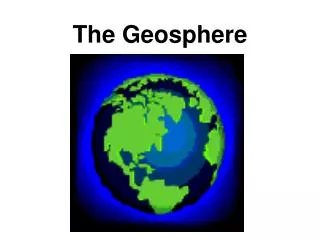
The Geosphere. Lesson Objectives. Learn to identify the approximate age of the Earth Learn to correctly identify key parts of the Earth’s shape and structure Learn to explain the existence of the Earth’s magnetic field Learn to explain plate tectonics

E N D
Lesson Objectives • Learn to identify the approximate age of the Earth • Learn to correctly identify key parts of the Earth’s shape and structure • Learn to explain the existence of the Earth’s magnetic field • Learn to explain plate tectonics • Learn to correctly identify different types of faults • Learn to explain the differences between a mineral and a rock • Learn to correctly identify different minerals • Learn to correctly identify igneous, sedimentary and metamorphic rocks • Learn to identify the processes that form sediments • Learn to identify the processes that form metamorphic rocks
The Earth’s general shape is…. • A. planar (flat) • B. spherical (round like a ball) • C. pyramid (like those in Egypt) • D. cylindrical (like a soda can)
Eratosthenes studied the suns rays on the summer solstice around 250 BC. http://en.wikipedia.org/wiki/File:Portrait_of_Eratosthenes.png On June 21, there was a well in Syene that the Sun could be seen reflected directly in the well. So Eratosthenes set up a pole in Alexandria 800 km away and measured the angle of the shadow. He used geometry to calculate the shape and diameter of the Earth. He was close to the modern value of 40,000 km.
The Principle of Uniformitarianism James Hutton was a Scottish physician and geologist from the 18th century. His theory can be summized as “the present is the key to the past.” – Understanding Earth, Grotzinger http://www.nndb.com/people/213/000104898/james-hutton-1-sized.jpg Geologist use the geological record to understand the past by using processes observed today. Rock formations and fossils in rocks help us understand Earth’s past.
James Hutton figured out the shape of the Earth? • A. True • B. False
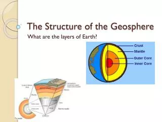
http://studentcenters.wikispaces.com/file/view/earth_core3.jpghttp://studentcenters.wikispaces.com/file/view/earth_core3.jpg http://makingsenseofmaths.com.au/wp-content/photos/fib_apple_1.jpg The Earth has a core and layers like an apple.
Crust – 0 km to 40 km 0.4% of Earth’s Mass • Mantle – 40 km to 2890 km 68.1% of Earth’s Mass • Liquid Outer Core – 2890 km to 5150 km 30.8% of Earth’s Mass • Solid Iron Core – 5150 km to 6370 km 1.7% of Earth’s Mass http://makingsenseofmaths.com.au/wp-content/photos/fib_apple_1.jpg
Our magnetic field protects the surface of the Earth from harmful radiation. It helps keep the atmosphere from being “peeled” away by solar winds. http://www.windows2universe.org/sun/images/sunspot_horseshoe_magnet_big.jpg The magnetic field is thought to be generated by the interaction of the inner solid iron core and the outer liquid core. The two cores spin at different rates and this is called the geodynamo system.
Plate Tectonics • http://youtu.be/RuScA58BgRE
Divergent zones create faults known as normal faults. The hanging wall moves down in relation to the foot wall. The layers of rocks help identify the type of a fault. The best example is in ocean trenches. http://www.uwsp.edu/geo/faculty/ritter/images/lithosphere/tectonics/normal_fault_labelled_diagram.jpg
Convergent zones create faults known as reverse faults. The hanging wall moves up in relation to the foot wall. The layers of rocks help identify the type of a fault. The best example is fault creating the Himalayas. http://www.uwsp.edu/geo/faculty/ritter/images/lithosphere/tectonics/reverse_fault_diagram_small.jpg
Strike slip faults are located where two plates are sliding past each other. Surface structures will show the direction of the movement. The San Andreas fault in California is a good example of a strike slip fault. http://www.nature.nps.gov/geology/usgsnps/deform/strikeslip.gif http://www.smate.wwu.edu/teched/geology/GeoHaz/eq-Armenia/eq-Armenia-20.JPG
Plate Tectonics in Action • An animation of plate tectonics • Examples of faults in actions
http://upload.wikimedia.org/wikipedia/commons/7/72/Coal_anthracite.jpghttp://upload.wikimedia.org/wikipedia/commons/7/72/Coal_anthracite.jpg http://upload.wikimedia.org/wikipedia/commons/f/f3/GraphiteUSGOV.jpg All of these have a high carbon content but what are the differences? http://upload.wikimedia.org/wikipedia/commons/thumb/8/8f/Apollo_synthetic_diamond.jpg/220px-Apollo_synthetic_diamond.jpg
Minerals • Minerals are the building blocks of rocks. • Silicates, Carbonates, Oxides, Sulfides and Sulfates are the most common. • Mineral is defined as a naturally occurring solid crystalline substance, generally inorganic with a specific chemical composition.
Is ice in the arctic a mineral? • A. Yes • B. No
Arctic ice is a mineral since it is naturally occurring and is a crystal. However, ice in your freezer is not a mineral since it is not naturally occurring. http://www.mediawavefestival.hu/UserFiles/ice_cube_actin_hard(1).jpg http://www.barcelonareporter.com/img_uploads/Arctic_ice.jpg
http://www.washington.edu/uwired/outreach/teched/projects/web/rockteam/WebSite/rcycle.gifhttp://www.washington.edu/uwired/outreach/teched/projects/web/rockteam/WebSite/rcycle.gif
Example: Basalt There are two types of Igneous rocks Extrusive – formed on the Earth’s surface, have fine crystals http://fineartamerica.com/images-medium/fallen-columnar-basalt-at-devils-postpile-greg-clure.jpg Intrusive – formed inside the Earth, have course crystals Example: Granite http://www.seeyosemite.com/images/granite-rock.jpg
Through weathering processes, the building blocks of sedimentary rocks are created. Sediment can also be left over plant and animal matter. http://www.beg.utexas.edu/mainweb/publications/graphics/limestone400.jpg http://photography.nationalgeographic.com/staticfiles/NGS/Shared/StaticFiles/Photography/Images/POD/s/sandstone-pedestal-525417-ga.jpg http://geology.com/rocks/pictures/breccia.jpg
If existing rocks are put under pressure and/or temperature, they under go a metamorphosis into a new rock. These rocks have crystalline changes and can have foliation. http://www.pitt.edu/~cejones/GeoImages/6MetamorphicRocks/Gneiss/Gneiss1RailRoadCUp.jpg http://www.allaboutgemstones.com/images/metamorphic_rock_banded_hornfels.jpg
Inspiration Assignment http://yhs-wooten.wikispaces.com/file/view/rock_cycle.png/40248382/rock_cycle.png