Download

1 / 5
0 likes | 1 Vues
At 3Deling, we specialize in delivering precise topographical surveys and high-quality 3D CAD models that empower architects, engineers, and construction professionals with accurate data for informed decision-making.

E N D
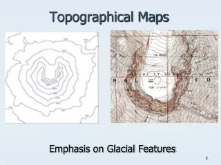
Accurate Topographical Surveys and 3D CAD Models for Every Project At 3Deling, we specialize in delivering precise topographical surveysand high-quality 3D CAD models that empower architects, engineers, and construction professionals with accurate data for informed decision-making. Our topographical surveys provide detailed measurements of land surfaces, capturing elevations, contours, and features with the highest precision. This essential data forms the basis for planning, design, and development projects, ensuring efficiency from the start. Using state-of-the-art scanning and surveying technology, 3Deling captures millions of data points quickly and accurately. The information is then transformed into comprehensive 3D CAD models that give clients a clear and reliable representation of the surveyed site. These models are invaluable for understanding spatial relationships, detecting potential design issues, and facilitating seamless project execution.
Our 3D CAD modelsserve a wide range of applications including construction planning, infrastructure development, land management, and heritage preservation. By combining accurate topographical survey data with advanced modeling, we help minimize risks, reduce rework, and ensure projects are delivered on time and within budget. 3Deling’s expert team works closely with clients to deliver customized solutions, whether you need detailed 2D drawings, 3D visualizations, or BIM-ready files. We pride ourselves on accuracy, reliability, and efficiency, offering services tailored to projects of any scale. Choose 3Deling for professional topographical surveys and 3D CAD models that turn real-world landscapes into precise digital assets. With our expertise, you gain a trusted partner dedicated to ensuring the success of your projects from start to finish.
Contact us : Name : 3Deling Mobile : +44 7739 036 829 Email :mail@3deling.com Website : https://3deling.com/index.html