Download
1 / 12
160 likes | 1.09k Vues
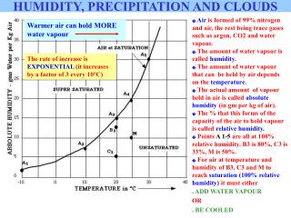
Warmer air can hold MORE water vapour. Air is formed of 99% nitrogen and air, the rest being trace gases such as argon, CO2 and water vapour. The amount of water vapour is called humidity . The amount of water vapour that can be held by air depends on the temperature .

E N D
Warmer air can hold MORE water vapour • Air is formed of 99% nitrogen and air, the rest being trace gases such as argon, CO2 and water vapour. • The amount of water vapour is called humidity. • The amount of water vapour that can be held by air depends on the temperature. • The actual amount of vapour held in air is called absolute humidity (in gm per kg of air). • The % that this forms of the capacity of the air to hold vapour is called relative humidity. • Points A 1-5 are all at 100% relative humidity. B3 is 80%, C3 is 33%, M is 50%. • For air at temperature and humidity of B3, C3 and M to reach saturation(100% relative humidity) it must either • ADD WATER VAPOUR OR • BE COOLED HUMIDITY, PRECIPITATION AND CLOUDS The rate of increase is EXPONENTIAL (it increases by a factor of 3 every 10°C)
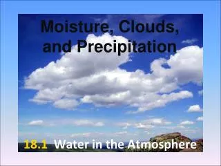
H2O can exist in solid, liquid, or gaseous states. Change from liquid to gas is evaporation. Change from gas to liquid is condensation. Change to/from the solid to gas is sublimation. • Evaporation occurs where water is plentiful (over oceans, water and transpiring vegetation) • Condensation occurs where the relative humidity 100% (saturation) which occurs when evaporation is rapid or where the air is cooled. • Rapid evaporation occurs over water or forests. • AIR COOLING occurs by: • Mixing with cooler air • Contact with cold surface • Movement (advection) over colder ground • Lifting of air up through the atmosphere Ppt C T E When air is saturated, the rate of evaporation equals condensation CONDENSATION E - Evaporation T - Transpiration C - Condensation Ppt - Precipitation Over oceans, evaporation is likely to exceed Ppt. Over land, Ppt is likely to exceed evaporation.
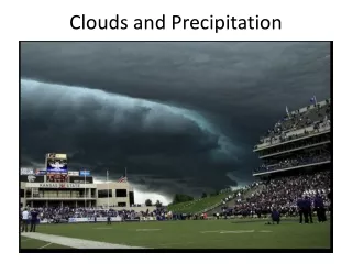
Mixing of air along a front betwen two air masses results in clouds along the front COOLING OF AIR - 1 • MIXING • Condensation may occur when warmer and cooler air masses mix together at their margins
COOLING OF AIR - 2 • Ground level condensation may occur due to movement of warmer air across a cooler surface (this may be land or sea). This lateral movement of air is called ADVECTION. Here, warm air from the land is cooled when it passes over colder water (in summer, usually). Sea fogs are produced in this way, when air above warmer water moves across colder water and is cooled.
COOLING OF AIR - 3 • RADIATION • Ground level condensation may also occur when stationary air is cooled by a ground surface that cools, usually overnight. Cooling is fastest when no cloud cover exists to reflect outgoing long-wave terrestrial radiation Cold surfaces are common in mountains, where snow reflects solar radiation and remains cold, cooling air in contact with the ground.
ADVECTION & RADIATION Frost froming under clear skies which aid radiation cooling of the ground Frost Dew Icicles - a combination of freezing and frost COOLING OF AIR - 2 and 3 Both radiation and advection cooling result in cooling of air at ground level. If the air is cooled below its dew point temperature, condensation of the water vapour held by the air may take place on any surfaces available. Solid ice also forms when water on the surface freezes; this is not frost, though frost may add to it. The most available surface is the ground itself, or the vegetation. This is called dew. If dew freezes, frost is formed. If dew point temperature is below 0°C, vapour changes directly into ice, forming hoar frost. Excessive humidity or many particles in the air cause fog, when condensation occurs on particles in the air. This is common in cities where pollution produces particles - producing smog (smoke & fog).
ASCENT • When air is lifted up through the atmosphere it cools at 0.6°C per 100m • It cools due to decompression because air is less dense at higher altitudes. • Cooling causes relative humidity to rise (cooler air can hold less water vapour). • If air cools to dew point temperature, condensation occurs on any available surfaces - at altitude, this can only be particles in the air (or aeroplanes etc) • Such particles are essential for condensation, and come from volcanic dust, sea salt from evaporated spray etc • Some, eg salt, attract water (hygroscopic nucleii) and form clouds easily. • Clouds form from such condensation. They are simply countless billions of water droplets or ice crystals too light to fall to ground. Whether ice or water depends on the altitude and temperature. • Precipitation may occur if uplift continues COOLING OF AIR - 4 UPLIFT OF AIR IS ESSENTIAL FOR CLOUD FORMATION AND RAINFALL There are 3 mechanisms which may cause the uplift of air.
Cloud formation continues as high as air rises. When air stops rising, cloud development stops. The more uplift, the taller and deeper the clouds RISING AIR and CLOUD FORMATION CLOUD TOP • Relative humidity reaches 100% (saturation) at dew point temperature. Water vapour starts to condense on particles above this level - cloud base level. Saturated air cools more slowly than 0.6°C per 100m, making it more likely to continue to rise (unstable) and produce deeper clouds CLOUD CLOUD BASE • Rising air expands with less pressure at altitude. This causes cooling, which causes relative humidity to rise. Air continues to rise as long as it is forced upwards, or surrounding air is NOT as warm as the rising air. • Air at ground level is forced to rise.
Cloud base is constant across a wide area, as any of the air mass (constant in temperature and relative humidity) reaches dew point at the same altitude - about a 1000m? The size and shape of clouds depends entirely on the amount of uplift of the air. The altitude of cloud base depends on the altitude of the condensation level ie the altitude at which cooling air reaches dew point temperature (saturation, or 100% relative humidity) UPLIFT CONTINUES CLOUD FORMATION Here, uplift is so strong that the cloud is very deep, and rainfall occurs. LIMITED UPLIFT CAUSES SHALLOW CLOUDS CLOUD BASE at CONDENSATION LEVEL Below, a forest fire has caused a cloud (not just smoke) due partly to the heat casuing convection, but mainly to the increased number of ash particles which increase the rate of condensation.
Rising air expands, cools, relative humidity rises to 10% at dew point temperature above which condensation of water vapour occurs on particles to form clouds SNOWDONIA Westerly winds blow humid air onshore from the Atlantic Ocean Air sinks down on leeside of high land, contracts due to denser air, warms up, relative humidity falls and rainfall diminishes. This results in an area of lower rainfall, called a rain shadow. An example is lowland to the east of Britain, such as East Anglia. WHY AIR RISES (1) - RELIEF Cloud development stops when air is no longer forced up. Condensation level
Condensation level Air meets air equally warm, stops rising, descends WHY AIR RISES (2) - CONVECTION Solar radiation heats up ground surface Condensation level Air warms by contact with warm ground surface, becomes less dense and rises Rising air expands, cools, relative humidity rises until condensation of water vapour occurs above condensation level. WHY AIR RISES (3) - FRONTAL Rising air expands, cools and relative humidity rises until it reaches 100% (saturation) at condensation level above which clouds form as water vapour condenses on particles. Cooler, denser air sinks downwards and forces lighter, warmer air to rise Warmer, lighter air is forced to rise by denser cooler air.
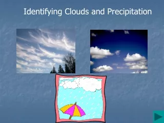
The shape and depth of clouds depend on the temperature and humidity of the air, and the degree of uplift to which it is subjected. CUMULUS WITH LIMITED VERTICAL DEVELOPMENT CIRRUS CLOUDS CUMULUS DEVELOPS INTO CUMULO-NIMBUS LENS CLOUDS CUMULO-NIMBUS CONVECTIONAL UPLIFT results in cumulus clouds. If uplift is continued, then they develop vertically to become storm clouds; cumulo-nimbus which only spread out laterally at the tropopause (about 12km). CLOUD TYPES CIRRUS clouds are thin, wispy clouds formed from ice crystals at high level, usually near the tropopause at 10-12km. CONTRAILS are the trails of jet aircraft whose water vapour condenses into ice crystals. STRATUS clouds are layerclouds that develop with whole air masses rising gently, with limited vertical development Lens clouds develop as air streams oscillate above and below the condensation level. Stratus clouds Stratus clouds from above