Monitoring Deforestation in Amazonia
350 likes | 659 Vues
Monitoring Deforestation in Amazonia. Gilberto Câmara, INPE, Brazil. How much land change is happening? Where are land changes taking place? . Global Change. Who is causing the change ? What are the impacts of public policies? What will happen in the future?.

Monitoring Deforestation in Amazonia
E N D
Presentation Transcript
Monitoring Deforestation in Amazonia Gilberto Câmara, INPE, Brazil
How much land change is happening? Where are land changes taking place? Global Change Who is causingthechange? What are theimpactsofpublic policies? Whatwillhappen in the future?
photo source: Edson Sano (EMBRAPA) Agricultural Trade in Brazil
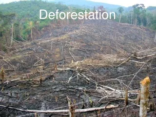
Processes of deforestation Slashandburn Progressivedegradation
Slash: start of dry season Burn: end of dry season Slash and burn
Progressive degradation Barlow and Peters (2008) Selectivelogging Wood extractionandburning Furtherburningandpasture Clearcut
T1 – Selectivelogging T2 – Lossofsmallertrees T3 – Loss >50% offorest T4 – Loss >90% offorest Progressive degradation
Severelydegradedforest Pasture
Deforestation as an event Clearcut Forest Clear cut – end of deforestation (objective and definitive)
PRODES: Clear-cutdeforestationmapping ~230 scenes Landsat/year Yearly detailed estimates of clear-cut areas
Is deforestation an event or a process? Clearcut Forest ? What happens between the pristine forest and the clear cut?
DETER: Real -time Deforestation Monitoring 15-day alerts of newly deforested large areas
Intensiveexploitation Exploração intensiva time Howfar is detection time from real-world time? Perda >50% do dossel Loss >50% DETER – alert 1 Perda >90% do dossel Loss >90% DETER – alert 2 Corte raso Clearcut DETER – final alert Floresta Floresta
How hard is to use MODIS images to detect deforestation? Landsat/TM August 2007 MODIS November 2007 Alerta DETER nov-2007
CheckingDETER´s data (February 2008) Clear-cut for pasture
Monthly reports: May 2008 Clear-cut Intensiveimpact Moderateimpact Lowimpact Error
TerraAmazon – open source software for large-scale land change monitoring 116-112 116-113 166-112 Spatial database (PostgreSQL with vectors and images) 2004-2008: 5 million polygons, 500 GB images
Comparison between Segmentation A comparison of segmentation programs for high resolution remote sensing data, G. Meinel, M. Neubert, ISPRS Congress, 2004
INPE’s space technology agenda “Global EO” – Brazil as global player in earth observation Bilateral agreements (China, Germany, UK) Multilateral Agreements (CEOS, GEO)
CBERS as a global satellite CBERS ground stations will cover most of the Earth’s land mass between 300N and 300S
“A few satellites can cover the entire globe, but there needs to be a system in place to ensure their images are readily available to everyone who needs them. Brazil has set an important precedent by making its Earth-observation data available, and the rest of the world should follow suit.”
INPE´s Remote Sensing Satellites: 2007-2020 CBERS: China Brazil Earth Resources Satellite Amazônia-1: 100% Brazilian 2007 2008 2009 2010 2011 2012 2013 2014 2015 2016 2017 2018 2019 CBERS-4 CBERS-6 CBERS-5 CBERS-SAR CBERS-3 CBERS-2B Amazônia-1 Amazônia-3 Amazônia-2 N.B.: CBERS-2, launched 2003, is still operational
Optical Satellites for Tropical Forests 100 Technology 2000 MUX CBERS-3/4 50 Technology 2008 Forestry CCD CBERS-2/3/4 Mapping MUX CBERS-5/6 Technology 2015 Land Use LANDSAT Description 10 Revisit (days) Deforestation Detection 5 AWFI CBERS-3/4 AWFI Amaz-1/2 AWFI CBERS-5/6 WFI CBERS-2 MODIS 1 5 50 500 1 10 100 1000 Resolution (metres)
Sensors for monitoring tropical areas 780 km swath Amazônia-1 AWFI 40 m groundresolution 5 days global coverage 720 km swath CBERS-3/4 AWFI 60 m ground resolution 5 days global coverage 120 km CBERS-3/4 CCD 20 m ground resolution 26 days global coverage CBERS-3/4 MUX 60 km 5 m ground resolution 52 days global coverage (5 days with mirror)
CBERS-2B Sensor Configuration WFI 260 m (890 km) CCD 20 m (120 km) PAN 2.5 m (27 km) 0.4 0.5 0.7 0.9 1.1 1.5 1.7 2.3 2.5 mm Built by China Built by Brazil
CBERS-2B CCD-HRC combinedimage in São Felix (Pará, Brasil) Approximatescale 1:10.000
CBERS 3 – 4 Sensors (under construction) Visible – Near IR Mediumwave IR Thermal IR Short wave IR AWFI 60 m (720 km) IRMSS 40 m (120 km) CCD 20 m (120 km) MUX 5/10 m(120 km) 3.7 3.9 3.5 10 12 1.5 1.7 2.1 2.3 0.4 0.5 0.7 0.9 µm Built by Brazil Built by China
Amazônia-1 (under construction) AWFI Global land imaging every 3 days together with CBERS-3 (UK will include a 10-meter camera) 0,45-0,52B 0,52-0,59G SpectralBands(m) 0,63-0,69R 0,77-0,89NIR Spatialresolution(m) 40 Groundswath(km) 780 5 Revisit (days)
CBERS 5 – 6 Sensors (under discussion) Visible – Near IR Mediumwave IR Thermal IR Short wave IR IRMSS 20 m (120 km) AWFI-2 20 m (720 km) MUX 5/10 m (120 km) 3.7 3.9 3.5 10 12 1.5 1.7 2.1 2.3 0.4 0.5 0.7 0.9 µm Built by Brazil Built by China
International credibility helps… “Today, Brazil’s monitoring system is the envy of the world. INPE has its own remote sensing satellite, a joint effort with China, that allows it to publish yearly totals of deforested land that scientists regard as reliable.” TerraAmazon
...especiallywhen real money is involved! Until 2015, Norway will give up to US$ 1 billion to reduce deforestation in the Amazon. Norway’s contribution will depend on how successful Brazil will be in reducing deforestation. Brazilhas the largest rain forest and one of the world’s most advanced systems for surveillance of deforestation.