Download
1 / 6
60 likes | 240 Vues
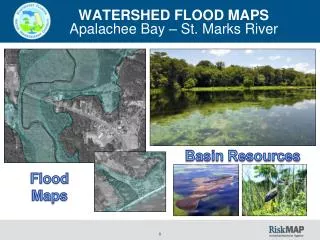
NWFWMD. Apalachee Bay and St. Marks River Watershed Risk Map Stakeholder Meeting. August 13, 2014. Watershed Vision. Risk MAP will … identify existing data and seek to obtain and … communicate flood hazard data that… increases public awareness and leads to …

E N D
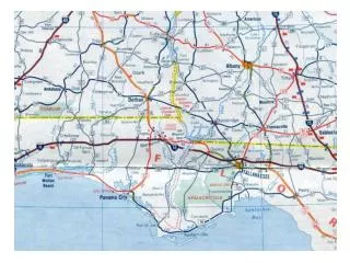
NWFWMD Apalachee Bay and St. Marks River Watershed Risk Map Stakeholder Meeting August 13, 2014
Watershed Vision Risk MAP will … identify existing data and seek to obtain and … communicate flood hazard data that… increases public awareness and leads to … action that reduces risk to life and property by… connectinghazard mapping, hazard mitigation and the NFIP through the mapping process at the community level while… creating data crucial for … emergency operations in the event of a natural disaster.
DISCOVERY • FEMA’s Risk MAP program Discovery process helps communities identify areas at risk for flooding and solutions for reducing that risk. • To work closely with communities to better understand local flood risk, mitigation efforts, and other topics and spark watershed-wide discussions about increasing resilience to flooding.
Overall Meeting Goals: • Get to know your community better and your view of the flood protection measures and assets you have. • Obtain new flood hazard information, plans, and data. • Understand how we can build upon the existing maps and flood hazard mitigation plans. • Plan for the future and Post Meeting Follow Up
We Are Holding This Meeting To Engage Our Stakeholders: • Where would you like to see improvements in flood hazard maps in your community? • What are your suggestions or ideas to help build a better or more flood resistant community? • What is your vision for the watershed’s future, as well as the importance of mitigation planning and community outreach


![Flood Risk Review Meeting: [Watershed Name]](https://cdn1.slideserve.com/2624189/flood-risk-review-meeting-watershed-name-dt.jpg)

![Risk MAP and Discovery FEMA Region [#], [WATERSHED NAME] Watershed](https://cdn1.slideserve.com/2868558/risk-map-and-discovery-fema-region-watershed-name-watershed-dt.jpg)

![Flood Risk Review Meeting: [Watershed Name]](https://cdn2.slideserve.com/3807999/flood-risk-review-meeting-watershed-name-dt.jpg)