Download
1 / 25
250 likes | 623 Vues
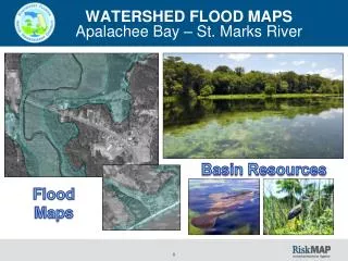
WATERSHED FLOOD MAPS Apalachee Bay – St. Marks River. Basin Resources. Flood Maps. WATERSHED FLOOD MAPS. APALACHEE BAY – ST. MARKS RIVER WATERSHED AERIAL. Base map for the development of flood maps Helps understand the water resource. WATERSHED FLOOD MAPS.

E N D
WATERSHED FLOOD MAPSApalacheeBay – St. Marks River Basin Resources Flood Maps
WATERSHED FLOOD MAPS APALACHEE BAY – ST. MARKS RIVER WATERSHED AERIAL • Base map for the development of flood maps • Helps understand the water resource
WATERSHED FLOOD MAPS POPULATION2010 CensusTotal Basin Population353,476 MAP IN PRODUCTION
LAND USE WATERSHED FLOOD MAPS Total Basin Size (NWFWMD) = 543 sq. mi. [Forest/Wetlands = 790 sq. mi. (76%)]
WETLANDS WATERSHED FLOOD MAPS • 325 sq. mi. of wetlands in the basin • Help attenuate flood flows • Provide a significant amount of flood storage • NWFWMD ERP provides wetland protection & mitigation • NWFWMD dam safety regulatory program
CONSERVATION LANDS WATERSHED FLOOD MAPS • Most are within the Apalachicola National Forest & the St. Marks Wildlife Refuge • Along with public preservation and recreation opportunities, conservation lands are a preventive measure that helps keep development out of the flood zone.
WATERSHED FLOOD MAPS GAGE LOCATIONS MAP IN PRODUCTION • Existing gages • Useful for flood warning and flood study model calibration
LiDAR DATA WATERSHED FLOOD MAPS • NWFWMD LiDAR data base • DEM for entire basin • Important base data that is used throughout the district for flood mapping
SPECIAL FLOOD HAZARD AREA(SFHA) WATERSHED FLOOD MAPS
WATERSHED FLOOD MAPS Escambia CountySFHA w/ Panel Scheme MAP IN PRODUCTION • Map Modernization – upgraded maps in Escambia County • Maps revised and went effective on September 29, 2006
WATERSHED FLOOD MAPS Santa Rosa CountySFHA with Panel Scheme MAP IN PRODUCTION • Map Modernization – upgraded maps in Santa Rosa County • Maps revised and went effective on September 29, 2006
WATERSHED FLOOD MAPS Okaloosa County SFHA with Panel Scheme MAP IN PRODUCTION • Map Modernization – upgraded maps in Okaloosa County – Effective = December 6, 2002 • Now we are working under the risk map program to further improve the flood maps.
WATERSHED FLOOD MAPS Current On-going Non-Coastal Studies
NWFWMD Flood Information Portalhttp://portal.nwfwmdfloodmaps.com/
NWFWMD Flood Information Portalhttp://portal.nwfwmdfloodmaps.com/
NWFWMD Flood Information Portalhttp://portal.nwfwmdfloodmaps.com/
NWFWMD Flood Information Portalhttp://portal.nwfwmdfloodmaps.com/
NWFWMD Flood Information Portalhttp://portal.nwfwmdfloodmaps.com/
NWFWMD Flood Information Portalhttp://portal.nwfwmdfloodmaps.com/
DEM • CONTOURS
WATERSHED FLOOD MAPSPensacola Bay QUESTIONS?


![Making maps, many maps! [What is GIS?]](https://cdn1.slideserve.com/3592384/making-maps-many-maps-what-is-gis-dt.jpg)