SRTM Level-2, ASTER GDEM Quality comparison
310 likes | 577 Vues
SRTM Level-2, ASTER GDEM Quality comparison. Wm Matthew Cushing 18 February 2011, Sao Paulo Brazil U.S. Geological Survey (USGS) Earth Resources Observation and Science (EROS) Center. ASTER GDEM. 1.5 Million-scene ASTER scene to generate 1,264,118 DEM scenes

SRTM Level-2, ASTER GDEM Quality comparison
E N D
Presentation Transcript
SRTM Level-2, ASTER GDEMQuality comparison Wm Matthew Cushing 18 February 2011, Sao Paulo Brazil U.S. Geological Survey (USGS) Earth Resources Observation and Science (EROS) Center
ASTER GDEM 1.5 Million-scene ASTER scene to generate 1,264,118 DEM scenes ASTER GDEM accuracy +/- 20-m (Avg RMSE 9.35) ASTER GDEM shows an observed avg. negative 5-m bias Decrease in accuracy when terrain relief becomes high (greater the slope)
Artifacts and Residual Anomalies Resolution Residual Cloud Anomalies Steps at Scene Boundaries Pits Bumps Mole Runs Inland Water Bodies
Resolution It’s clear from visual examination of the following image that the ASTER GDEM is not as sharp as the SRTM Level-2 and contain less spatial detail. Further investigation indicated that GDEM’s spatial resolution is around 100 m, compared to that of SRTM Level-2 at around 50 m (METI/ERSDAC 2009; Farr 2006).
Resolution ASTER GDEM SRTM Level-2
Residual Cloud Anomalies Scene-based ASTER data contributed to the cloud anomalies. There remained many places on the Earth’s land surface for which no cloud-free scenes exist (METI/ERSDAC 2009). Fortunately for Sao Paulo State there were minimal cloud anomalies.
Residual Cloud Anomalies Cloud Anomalies These anomalies can be identified by a dramatic spike in elevation of thousands of meters.
Step at Scene Boundaries Linear boundaries that exist between swath-oriented zones of two different stack numbers are very common and are called “step anomalies” (METI/ERSDAC 2009).
Step at Scene Boundaries Step Anomaly
Pits, Bumps, and Mole Runs • Artifacts related to irregular stack number boundaries seem to be the source of the vast majority of artifacts. • Pits – pervasive small negative anomalies • Bumps – pervasive small positive artifacts equivalent to pits • Mole Runs – Positive curvilinear anomalies. Mole Run Bump Pit
Pits, Bumps, and Mole Runs Mole Run Bump Pit GDEM STACK ASTER GDEM
Pits, Bumps, and Mole Runs Mole Run Bump Pit GDEM STACK SRTM Level-2
Inland Water Body ASTER GDEM water body locations are not readily apparent due to the absence of a water body mask in the algorithm (METI/ERSDAC 2009).
Inland Water Body Water body ASTER GDEM SRTM Level-2
Summary ASTER GDEM overall global accuracy is approximately 20 m at 95% confidence. ASTER GDEM contains significant anomalies and artifacts.
Validation Summary Conclusion After careful review and consideration of the results and findings presented in this Validation Summary Report, METI and NASA decided to release the ASTER GDEM for public use and further evaluation. METI and NASA acknowledge that Version 1 of the ASTER GDEM should be viewed as “experimental” or “research grade.” However, they have decided to release the ASTER GDEM, because they believe its potential benefits outweigh its flaws and because they hope the work of the user community can help lead to an improved ASTER GDEM in the future (METI/ERSDAC 2009).
SRTM Data Characteristics SRTM data characteristics to consider prior to including the DEM in data analysis. Data voids Phase noise Canopy bias Horizontal resolution
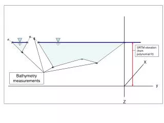
Data Voids Shaded Relief of DTED 1 SRTM with gaps (Voids) (Grohman, 2006)
Phase Noise An example of phase noise from two different surface types. A is from a rock outcropping, and B is bare soil with sparse vegetation
Canopy Bias Shaded Relief / Landsat image mosaic illustrating canopy bias along the borders of a protected forest in Ghana, West Africa. +
Canopy Bias Example of potential false channel extraction using SRTM data.
Horizontal Resolution Original data collection was near 30 m. Increased usability and smoothing algorithm was applied reducing resolution to 45 and 60 meters (Farr, 2006). Other studies show the resolution may be between 30 and 48 meters (Pierce, 2006).
Slope Overestimates in areas of steep topography Overestimates in areas of little relief (Guth, 2006; Jarvis, 2004; Farr, 2006) There is a combined influence of the smoothing algorithm and the phase noise error (Farr, 2006)
Overall SRTM Data Quality The SRTM is an unprecedented collection of the world's topography and currently there is no global dataset that can match its versatility and quality (Guth, 2006).
Feathering Method The feather method uses a fill source pixel at the same geographic area without adjusting for the difference in elevation (delta) and then “feathers” the edges between the different data sources to mitigate the difference in elevation. (Grohman, 2006)
Delta Surface Fill (Grohman, 2006)
References METI/ERSDAC, NASA/LPDAAC, USGS/EROS, 2009: ASTER Globel DEM Validation Summary Report, https://lpdaac.usgs.gov/lpdaac/products/aster_products_table/routine/global_digital_elevation_model/v1/astgtm (version 19 January 2011) Farr, T. G., et al. (2007), The Shuttle Radar Topography Mission, Rev. Geophys., 45, RG2004, doi:10.1029/2005RG000183. p 21- 22. Rodriguez, E., Morris, C. S., Belz, J. E., 2006. A Global Assessment of the SRTM Performance: Photogrammetric Engineering and Remote Sensing, v. 72, no. 3, p 249 - 260. Any use of trade, product, or firm names is for descriptive purposes only and does not imply endorsement by the U.S. Government.