Global Positioning Systems GPS
------Using GIS--. NR 143/385. INTRODUCTION TO GPS. Global Positioning Systems GPS. Lecture by Robert Long, University of Vermont Many materials for this lecture adapted from Trimble Navigation Ltd’s GPS Web tutorial


Global Positioning Systems GPS
E N D
Presentation Transcript
------Using GIS-- NR 143/385 INTRODUCTION TO GPS Global Positioning Systems GPS Lecture by Robert Long, University of Vermont Many materials for this lecture adapted from Trimble Navigation Ltd’s GPS Web tutorial at http://trimble.com/gps/index.html as well as from lectures originally prepared by Austin Troy, Gerald Livingston, and Leslie Morrissey
GPS • What is it? • How does it work? • Errors and Accuracy • Ways to maximize accuracy • System components
GPS • Stands for Global Positioning System • GPS is used to get an exact location on or above the surface of the earth (1cm to 100m accuracy). • Developed by DoD and made available to public in 1983. • GPS is a very important data input source.
GPS Uses • Trimble Navigation Ltd., breaks GPS uses into five categories: • Location – positioning things in space • Navigation – getting from point a to point b • Tracking - monitoring movements • Mapping – creating maps based on those positions • Timing – precision global timing
GPS Uses • The uses for GPS mapping are enormous. Here are just a few examples: • Centerlines of roads • Hydrologic features (over time) • Bird nest/colony locations (over time) • Fire perimeters • Trail maps • Geologic/mining maps • Vegetation and habitat
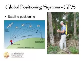
GPS • GPS is a worldwide radio-navigation system formed from 24 satellites and their ground stations. • Satellites orbit earth every 12 hours at approximately 20,200 km • GPS uses satellites in space as reference points for locations here on earth • Ground stations help satellites determine their exact location in space. • Hawaii • Ascension Island • Diego Garcia • Kwajalein • Colorado Springs
12,500 km 11,200 km 11,500 km How does GPS work? • GPS derives position relative to satellite “reference points,” using triangulation • The GPS unit on the ground figures out its distance to each of several satellites
How Does GPS Work? • We need at least 3 satellites as reference points to “triangulate” our position.
How Does GPS Work? Sphere Concept Source: Trimble Navigation Ltd. A fourth satellite narrows it from 2 possible points to 1 point
How Does GPS Work? • This method assumes we can find exact distance from our GPS receiver to a satellite. HOW??? • Simple answer: see how long it takes for a radio signal to get from the satellite to the receiver. • We know speed of light, but we also need to know: Distance = Velocity * Time • When the signal left the satellite • When the signal arrived at the receiver
How Does GPS Work? • The difficult part is measuring travel time • This gets complicated when you think about the need to perfectly synchronize satellite and receiver.
How Does GPS Work? • To do this requires comparing lag in exactly similar patterns, one from satellite and one from receiver. • This code has to be extremely complex (hence almost random), so that patterns are not linked up at the wrong place on the code. Source: Trimble Navigation Ltd.
How Does GPS Work? • The code also has to be generated from each source at exactly the same time. • So, the satellites have expensive atomic clocks that keep perfect time—that takes care of their end. • But what about the ground receiver?
How Does GPS Work? • Here is where the fourth satellite signal comes in. • While 3 perfect satellite signals can give a perfect location, 3 imperfect signals can’t, but 4 can • Remember the sphere example… • If receiver clock is correct, 4 circles should meet at one point. If they don’t meet, the computer knows there is an error in the clock: “ They don’t add up”
How Does GPS Work? • A fourth satellite allows a correction factor to be calculated that makes all circles meet in one place. • This correction is used to update the receiver’s clock.
How Does GPS Work? • The receiver then knows the difference between its clock’s time and universal time and can apply that to future measurements. • Of course, the receiver clock will have to be resynchronized often , because it will lose or gain time
Accuracy Depends On: • Time spent on measurements • Location • Design of receiver • Relative positions of satellites • Use of differential techniques
Sources of Error • Gravitational effects • Atmospheric effects • Obstruction • Multipath • Satellite geometry • Selective Availability
Errors and Accuracy (cont.) • Gravitational pull of other celestial bodies on the satellite, affecting orbit • Atmospheric effects - signals travel at different speeds through ionosphere and troposphere. • Both of these errors can be partly dealt with using predictive models of known atmospheric behavior and by using Differential GPS. Source: Trimble Navigation Ltd.
Errors and Accuracy (cont.) • Obstruction - Signal blocked or strength reduced when passing through objects or water. • Weather • Metal • Tree canopy • Glass or plastic • Microwave transmitters • Multipath – Bouncing of signals may confuse the receiver.
Errors and Accuracy (cont.) • Satellite Constellation Geometry • Number of satellites available • Elevations or azimuths over time Positional Dilution of Precision (P.D.O.P.)
Satellite 1 Satellite 1 Satellite 2 Satellite 2 High PDOP Low PDOP Errors and Accuracy (cont.) • PDOP • Indicator of satellite geometry • Accounts for location of each satellite relative to others • Optimal accuracy when PDOP is LOW
Locating Satellites • We know how far we are from the satellites, but how do we know where the satellites are? • Because the satellites are 20,000 km up, they operate according to the well understood laws of physics, and are subject to few random, unknown forces. • This allows us to know where a satellite should be at any given moment. • Also tracked by radar to measure slight deviations from predicted orbits.
Locating Satellites (cont.) • This location information (ephemeris) is relayed to the satellite, which transmits the info when it sends its pseudo random code. • There is also a digital “almanac” on each GPS receiver that tells it where a given satellite is supposed to be at any given moment. • Other information is relayed along with the radio signal: time-of-day, quality control info.
Errors and Accuracy (cont.) • Selective Availability (S.A.) • Until May of 2000, the DoD intentionally introduced a small amount of error into the signal for all civilian users. • SA resulted in about 100 m error most of the time • Turning off SA reduced error to about 30 m radius
Ensuring Accurate Locations • Adequate satellites • Low PDOP (≤ 4 excellent, 5-8 acceptable) • Averaging • Clear weather • Minimize multipath error • Use open sites • Appropriate planning (ephemeris, skyplots) > USE DIFFERENTIAL GPS
Differential GPS • Increase accuracy dramatically • This was used in the past to overcome Selective Availability (100m to 4-5m) • DGPS uses one stationary and one moving receiver to help overcome the various errors in the signal • By using two receivers that are nearby each other, within a few dozen km, they are getting essentially the same errors (except receiver errors)
INTRODUCTION TO GPS Differential GPS • DGPS improves accuracy much more than disabling of SA does • This table shows typical error—these may vary Source: http://www.furuno.com/news/saoff.html
How does DGPS work? • The stationary receiver must be located on a known control point • The stationary unit works backwards—instead of using timing to calculate position, it uses its position to calculate timing
How does DGPS work? • Can do this because, precise location of stationary receiver is known, and hence, so is location of satellite • Once it knows error, it determines a correction factor and sends it to the other receiver.
How does DGPS work? • Message sent to rover with correction factor for all satellites. • More reference stations becoming available.
Other DGPS Concepts • Real-time vs. Post-processing • Wide Area Augmentation System (WAAS)
System Components • Receiver • Receives satellite signals • Compiles location info, ephemeris info, clock calibration, constellation configuration (PDOP) • Calculates position, velocity, heading, etc… • Data Collector • Stores positions (x,y,z,t) • Attribute data tagged to position • Software • Facilitates file transfer to PC and back • Performs differential correction (post-processing) • Displays data and permits file editing.
15m System Components - Receivers • Course/Acquisition (C/A) Code Receivers • Civilian grade • Use info in satellite signals to calculate position • 12-40m CEP* without differential correction • <1-5m CEP with differential correction • Do not need to maintain constant communication (lock) with satellites • Can be used under forest canopy CEP: 50% of positions are within a horizontal circle of a radius equal to the specified length.
System Components - Receivers • Carrier Phase (P-Code) Receivers • Military or survey grade • Uses actual radio signal to calculate position • ± 1cm SEP* (50% of locations within sphere of this radius) • Must record positions continuously from at least 4 satellites for at least 10 minutes – requires clear view • Number of Channels • 4 satellites for accurate 3D positions, 5 or more for highest accuracy • 9-12 satellites required to track all visible satellites at given moment
Review • What is it? • How does it work? • Errors and Accuracy • Ways to maximize accuracy • System components