Download

1 / 4
40 likes | 76 Vues
Learn about the technology, benefits, limitations, and future of GPS in surveying. Understand how GPS works, its accuracy, methods, and challenges. Explore the advancements and requirements for surveyors in the field.

E N D
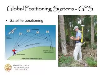
Global Positioning Systems (GPS) • Developed in early 1980’ s (Dept. of Defense) • Made up of 26 satellites (24 functioning & 2 spares) • Each satellite is 20,000 km high (off Earth’s surface) • Each satellite is in a fixed position • Minimum of 3 satellites needed, but 4-5 preferred • Need satellites at least 15° above horizon • Locate positions on Earth by distance-distance intersection • Need 2-3 receivers ($80-$100K per system) • Most accurate with double occupancy (no other checks) • Differential GPS – one receiver on known point, other receiver on unknowns
Global Positioning Systems (GPS) Biggest advantage • Distance and direction in-between 2 points without being seen Downfalls/Limitations of GPS • Multipath – bouncing off of walls of buildings • Blocked signals – clouds, trees, etc. • Sunspot – defraction from atmosphere • DOP (Delusion of Position) – bad satellite position • Set up error – not set up exactly over point (human error – most common)
Global Positioning Systems (GPS) Methods • Static – observation time is at least an hour • Ideally set points in triangular fashion • Accuracy – 1/10 million • RTK (Real Time Kinematic) – stand for 30-60 seconds minimum • Base receivers transmission, does corrections, sends corrections to receivers • Limitations – limitation of transmitter signal
Future of Surveying • Major advances in future • Remote Sensing (Government and Military) • Arial Photographs • Design Professions • Every 10 years, must justify to Legislature that need for our license exists • Surveyor have ULTIMATE liability • Standards → Laws • Continuing Education – Enough points every 2 years