Geographic Datums & Coordinates
Learn about the shape of the Earth, map projections, latitudes, longitudes, ellipsoids, vertical datums, and geoids. Discover how to convert heights and use map projections.

Geographic Datums & Coordinates
E N D
Presentation Transcript
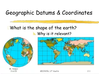
Geographic Datums & Coordinates What is the shape of the earth? Why is it relevant? GEO420k, UT Austin
Make a Map, Graph the World • What determines spacing of 30o increments of Lat. & Lon. ? • Dimensions and shape of earth(= DATUM) • Map Projection • Map Scale Austin: (-97.75, 30.30) X-axis Y-axis • Graph shows 30o increments of Lat. & Lon. at ~ 1:385,000,000 GEO420k, UT Austin
The Figure of the Earth • Models • Sphere with radius of ~6378 km • Ellipsoid (or Spheroid) with equatorial radius (major axis) of ~6378 km and polar radius (minor axis) of ~6357 km • Difference of ~21 km is usually expressed as the “flattening” (f) ratio of the ellipsoid: • f = difference/major axis = ~1/300 for earth GEO420k, UT Austin
Ellipsoid / Spheroid • Rotate an ellipse around an axis (c.f. Uniaxial indicatrix of optical mineralogy) Rotation axis a = Major axis b = Minor axis X, Y, Z = Reference frame GEO420k, UT Austin
Standard Earth Ellipsoids GEO420k, UT Austin
Horizontal Datums Datum = ellipse and axis of rotation. Common North American datums: • NAD27 (1927 North American Datum) • Clarke (1866) ellipsoid, non-geocentric axis of rotation* • NAD83 (1983 North American Datum) • GRS80 ellipsoid, non-geocentric axis of rotation • WGS84 (1984 World Geodetic System) • GRS80 ellipsoid, nearly identical to NAD83 • Other datums in use globally GEO420k, UT Austin
Datum “shifts” • Coordinate shift by use of improper datum can result in horizontal positioning errors as great as 800 m • An example compares the WGS84 location of the Texas state capitol dome to 13 other datums. GEO420k, UT Austin
Latitude and Longitude +30o (North) Latitude -30o (West) Longitude GEO420k, UT Austin
Latitude facts: • Lines of latitude (parallels) are evenly spaced (small circles) from 0o at equator (a great circle) to 90o at poles. • 60 nautical miles (~ 110 km)/1o, ~1.8 km/minute and ~ 30 m/second of latitude. • N. latitudes are positive (+f), S. latitudes are negative (-f). GEO420k, UT Austin
P.M. 180o Longitude facts: • Lines of longitude (meridians) converge at the poles; the distance of a degree of longitude varies with latitude. • Zero longitude is the Prime (Grenwich) Meridian (PM); longitude is measured from 0-180o east and west of the PM. • East longitudes are positive (+l), west longitudes are negative (-l). GEO420k, UT Austin
Vertical Datums • Sea Level (MSL), Geoid • Geoid = surface of constant gravitational potential that best fits MSL • governed by mass distribution of earth • Ellipsoid (HAE = Height above ellipsoid) • Geometric surface • Datum used by most GPS receivers GEO420k, UT Austin
Sea Level (MSL), Geoid • Measure ht. of sea surface (via satellites) and connect with costal surveys on land to get geoid. • Sea “Level” (geoid) not level; as much as 700 m of relief globally. Earth Surface Ellipsoid Geoid GEO420k, UT Austin
Geoid, Ellipsoid and Elevation (z) Height above MSL(Orthometric height) H.A.E. Geoid height = H.A.E. Earth Surface Geoid (~MSL) Ellipsoid Geoid Height GEO420k, UT Austin
Geoid of the conterminous US GEOID99 heights (= Geoid – Ellipsoid) range from a low of -50.97 m (magenta) in the Atlantic Ocean to a high of 3.23 m (red) in the Labrador Strait. Source: NGS at http://www.ngs.noaa.gov/GEOID/GEOID99/geoid99.html GEO420k, UT Austin
To convert HAE to orthometric (elev. above MSL) height: • Need accurate model of geoid height (e.g. N.G.S. GEOID99) • GEOID99 has 1 x 1 minute grid spacing • Compute difference between HAE and Geoid height (online here for US) • Current model allows conversions accurate to ~ 5 cm • More precise orthometric heights require local gravity survey GEO420k, UT Austin
How do we get from 3D earth models to 2D maps? • Map Projections – transforming a curved surface to a flat graph • Rectangular coordinate systems for smaller regions – UTM, SPCS, PLS GEO420k, UT Austin
Laying the earth flat • How? • Projections – transformation of curved earth to a flat map; systematic rendering of the lat. & lon. graticule to rectangular coordinate system. Scale1: 42,000,000 Scale Factor0.9996 (for specific line(s)) Earth Globe Map Peters Projection Globe distanceEarth distance Map distanceGlobe distance GEO420k, UT Austin
Laying the earth flat • Systematic rendering of Lat. (f) & Lon. (l) to rectangular (x, y) coordinates: y 0, 0 x Geographic Coordinates(f, l) Projected Coordinates(x, y) Map Projection GEO420k, UT Austin
Laying the earth flat • “Geographic” display – no projection • x , y = f , l • coords. have same scale and spacing GEO420k, UT Austin
Laying the earth flat • How? Projection types: Orthographic Gnomonic Stereographic A’ a A’ A’ a a T’ T’ T’ T T T b B’ B’ b b B’ GEO420k, UT Austin
Developable Surfaces • Surface for projection: • Plane (azimuthal projections) • Cylinder (cylindrical projections) • Cone (conical projections) Cylinder and cone produce a line of intersection (standard parallel) rather than at a point StandardParallel T’ GEO420k, UT Austin
3 orientations for developable surfaces GEO420k, UT Austin
Tangent or Secant? • Developable surfaces can be tangent at a point or line, or secant if they penetrate globe • Secant balances distortion over wider region • Secant cone & cylinder produce two standard parallels StandardParallels GEO420k, UT Austin
Projection produces distortion of: • Distance • Area • Direction • Proximity • Shape Distortions vary with scale; minute for large-scale maps (e.g. 1:24,000), gross for small-scale maps (e.g. 1: 5,000,000) Goal: find a projection that minimizes distortion of property of interest GEO420k, UT Austin
Where’s the distortion? • No distortion along standard parallels, secants or point of tangency. • For tangent projections, distortion increases away from point or line of tangency. • For secant projections, distortion increases toward and away from standard parallels. Secant line Tangent Secant GEO420k, UT Austin
Horizontal Datum • Origin Coordinates • Secant Locations • Origin X, Y Values What needs to be specified? Geographic (unprojected) Lambert Conformal Conic GEO420k, UT Austin
Projections in common use, US • Lambert Conformal Conic • Projection used by USGS for most maps of conterminous US (E-W extent is large) • Used by SPCS for state zones that spread E-W (Texas) • Conformal GEO420k, UT Austin
Projections in common use, US • Cylindrical • Transverse Mercator – basis for UTM coordinate system and State Plane Coordinate Systems that spread N-S Standard Parallels3o apart GEO420k, UT Austin
Rectangular Coordinate Systems • Universal Transverse Mercator (UTM) • US military developed for global cartesian reference frame. • State Plane Coordinate System (SPCS) • Coordinates specific to states; used for property definitions. • Public Land Survey System (PLS) • National system once used for property description • no common datum or axes, units in miles or fractional miles. GEO420k, UT Austin
(Y) (x) UTM Coordinate System • T. M. secant projection is rotated about vertical axis in 6o increments to produce 60 UTM zones. Rotate in 6o increments UTM Zone is 6o wide GEO420k, UT Austin
UTM Coordinate System • Zone boundaries are parallel to meridians. • Zones numbered from 180o (begins zone 1) eastward and extend from 80o S to 84o N. UTM Zones 20 9 10 19 11 12 18 13 14 15 16 17 GEO420k, UT Austin
(Y) (x) UTM Coordinate System • Central meridian of each zone in US has a scale factor of 0.9996 (max. distortion). • Secants are 1.5o on either side of the central meridian. GEO420k, UT Austin
y N. Hemisphereorigin is(500,000m, 0) x x S. Hemisphereorigin is(500,000m, 10,000,000m) y UTM Coordinate System • Locations are given in meters from central meridian (Easting) and equator (Northing). • (-) Eastings avoided by giving X value of 500,000 m (“false easting”) to the Central Meridian • In S. hemisphere, equator is given “false northing” of 10,000,000 m to avoid (-) Northings. GEO420k, UT Austin
Y 99oW Zone 14 Austin Y = 3,000,000 mN Central Meridian(X = 500,000 m) UTM Coordinate System UTM Coordinates for central Austin: Zone 14 621,000 mE, 3,350,000 mN GEO420k, UT Austin
State Plane Coordinate System (SPCS) • Developed in 1930’s to provide states a reference system that was tied to national datum (NAD27); units in feet. • Updated to NAD83, units in meters; some maps still show SPCS NAD27 coordinates. • Larger states divided into several zones. • X, Y coordinates are given relative to origin outside of zone; false eastings and northings different for each zone. GEO420k, UT Austin
Texas NAD83 SPCS Austin:Central Zone ~ 944,000mE~ 3,077,000mN Y Austin X GEO420k, UT Austin
Public Land Survey System (PLS) • System developed to survey and apportion public lands in the US, c. ~1800? • Coordinate axes are principle baselines and meridians, which are distributed among the states. • Grid system based on miles and fractional miles from baseline and meridian origin. • Not in Texas or original 13 states GEO420k, UT Austin
Public Land Survey System (PLS) Step 2 Step 1 Section 33 Center Sec. 33 Step 3 T2S, R1W, Section 33 GEO420k, UT Austin
Summary • Projections transform geographic coordinates (f, l) to cartesian (x, y). • Projections distort distance, area, direction and shape to greater or lesser degrees; choose projection that minimizes the distortion of the map theme. • Points of tangency, standard parallels and secants are areas of no distortion. • A conformal map has the same scale in all directions. GEO420k, UT Austin
Summary (cont.) • Projection characteristics are classified by: • Light source location • Gnomonic • Stereographic • Orthographic • Developable surface • Plane (azimuthal) • Cylinder (cylindrical) • Cone (conic) • Orientation • Normal • Transverse • Oblique GEO420k, UT Austin