Projections
Projections. A practical guide. Geographic Coordinate System. Spheroid (or Ellipsoid). Can assume the earth is a sphere for small scale maps (1:5,000,000 or less). To maintain accuracy for larger scale maps (1:1,000,000 or larger) use a spheroid. Datums.

Projections
E N D
Presentation Transcript
Projections A practical guide
Spheroid (or Ellipsoid) • Can assume the earth is a sphere for small scale maps (1:5,000,000 or less). • To maintain accuracy for larger scale maps (1:1,000,000 or larger) use a spheroid.
Datums • A datum defines the position of the spheroid relative to the center of the earth.
Datums • NAD 1927 • Origin is Meades Ranch in Kansas • Commonly used for older datasets • NAD 1983 • Origin is the earth’s center of mass • Very close to WGS 1984 • WGS 1984 • Designed to be used worldwide • Default datum for GPS receivers
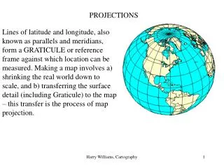
Spatial datasets should have: • Datum information • Every datum is associated with a geographic coordinate system (GCS).
Projected Coordinate Systems • A projected coordinate system is based on a geographic coordinate system which in turn is based on a datum.
Map Projections • All map projections distort one or more of the following properties • Area • Distance • Direction • Shape http://www3.interscience.wiley.com:8100/legacy/college/strahler/0471238007/animations/ch03_animations/animation2.html
Projected spatial datasets will have: • A datum and associated GCS. • A projection
Setting or defining projection • Do this to assign a projection to a dataset that has lost its projection information. • If you don’t know what projection to use: • Check the metadata or other information that came with the data. • Match the data in ArcMap with datasets with known projections. • Always work with a copy of your original dataset.
Projections in ArcMap • The data frame adopts the projection of the first dataset added to the map. • This projection can be changed in the data frame properties.
Washington projections • Geographic (Lat-Long) • UTM • Zone 10 (west) • Zone 11 (east) • State Plane (NAD 83 HARN) • North • South (default for whole state)
Pullman coordinates (NAD 83) • 117º 9’ 32.662” W 46º 43’ 51.049” N • -117.159º 46.731º • 487845 easting, 5175266 northing (meters) • 2477927 easting, 527365 northing (feet) NAD 27 • 487921 easting, 5175061 northing (meters) • 2837785 easting 527412 northing (feet)
Changing projections • Do this in ArcCatalog. Usually ArcMap needs to be closed. • Rasters and coverages have a different projection tool than shapefiles and geodatabase feature classes.