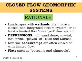
CLOSED FLOW GEOMORPHIC SYSTEMS
CLOSED FLOW GEOMORPHIC SYSTEMS. Landscapes with wetlands often have a closed, non-integrated stream system, or at least a limited flow “deranged” flow system. DEPRESSIONS : till, sand dune, coastal, lacustrine , “playas” of Texas and Kansas.

CLOSED FLOW GEOMORPHIC SYSTEMS
E N D
Presentation Transcript
CLOSED FLOW GEOMORPHICSYSTEMS • Landscapes with wetlands often have a closed, non-integrated stream system, or at least a limited flow “deranged” flow system. • DEPRESSIONS: till, sand dune, coastal, lacustrine, “playas” of Texas and Kansas. • Riverinebackswamps are often closed or with limited flow. • Flats such as “pocosins and planosols”. RATIONALE 5/5/2012 module 23
OBJECTIVES • Participants will draw cross-sections of closed or nearly closed landscapes, based on either topographic or soil map representations and some idea of the climatic regime. The participants will interpret the soils in terms of the hydrology.
BRINE PIT STUDY SITE 54 Ablation over Dense Lodgment Till - Salts NaCl SALINE BRINE PIT SLOPE SALT DESERT 600m Salts have moved to 30m depth Foss et al, 1985
TOPOGRAPHIC MAPOF THE BRINE PIT 54 SITE Arrow is about the maximum slope
Soil Boundaries Salt Boundary Oil Well Over 40 ac
LOW BULK DENSITY TILL HIGH BULK DENSITY TILL BRINE PIT Cross-Section withThroughflow PRECIPITATION FLOW ZONE CAPILLARY & ET LOSSES BRINE PIT THROUGHFLOW Is above the dense till. DENSE TILL Flow occurs seemingly only in fractures.
TWO TYPES OF EROSIONAL AND ONE UPLAND DEPRESSIONAL LANDSCAPES IN MOORE CO., TX SHERM, PULLMAN upland, with NESS depressions DALHART & FLOODPLAIN VERNON BADLANDS
SOIL SURVEY: MOORE CO., TXSECs. 229,230,250,249Yes these are the section #’s. NOTE: NO other drain- ages. SHERM 4Mi NESS SUNRAY
PLAYA PONDSMOORE CO., TXCLOSED DEPRESSIONS DALHART SHERM SUNRAY NESS
WATER TABLE CONTOUR MAP FENS CONTOUR INTERVAL 50 ft Bisson Lake study, MN.
SLOPE ARTESIAN CALCIAQUOLLS WINTER FLOW DEPRESSIONS ROAD PROBLEMS SEEPAGE NORTH TRANSECT BISSON LAKE STUDY N GLACIAL LAKE MAHONOMEN
Cross-Section FLOODPLAIN OF THE WAKARUSA RIVER, Kansas SOILS Upland WABASH READING PD & VPD WD “Bedrock” Mixed Alluvium Recent natural levee and colluvial sediments Lindbo, D. L., and J. L. Richardson. 2001
FLOODPLAIN OF THE WAKARUSA RIVER- Landforms Upland Back swamp Natural Levee yazoo Stream “Bedrock” Mixed Alluvium Recent natural levee and colluvial sediments Lindbo, D. L., and J. L. Richardson. 2001
Wakarusa River Floodplain, Kansas with Baker University Restoration LimestoneBedrock Upland Back swamp Drainage in old yazoo NaturalLevee Lindbo, D. L., and J. L. Richardson. 2001
SOILS of FLATS & SLOPES WAYNE CO., IA Edina Alboll Clarinda Aquoll Bt Bt Bt Bt
POCOSSIN TYPE OF WETLAND Click to add title Precipitation > 125 cm/year Mediasaprist Humaquept Soil Great Groups Umbraquult Typic Aeric Ochraquult MUCK Ochraquult Hapludult MUCK Coastal Plain Sediments NC, SC, VA, GA Soils after Tant et al. 1988 Hydrology after Richardson et al. 1992
RED LAKE MINNESOTA BLANKET PEAT Omnotrophic Bog Rich Fen Local Recharge Local Discharge MOSS PEAT SEDGE PEAT MARL LAKE SEDIMENTS GW flow from Till Upland Regional Discharge after Siegel & Glazer
PROBLEM: CLOSED FLOW SYSTEM Do this problem in teams of two. 2 DOMINANT SERIES 1 Tonka 2 Parnell 4 Southam 10 Svea& Hamerly 12 Vallers 40 Barnes 12 10 2 40 12 10 2 2 1 2 40 2 40 1 12 12 10 1 4 12 2 Spot symbol for map unit 1 OBJECTIVE 2
PROBLEM OBJECTIVES OBJECTIVE 1: - Create a cross-section along the red line, including slope profile, and soil distribution along the slope profile. - Draw the hydrology for pluvial (humid) and normal (sub-humid) times on the cross-section. - Describe and explain the development of these till soils since the prairie invasion in the last 8,000 years. OBJECTIVE 2: - Sketch a cross-section and contrast the 2 and 4 wetlands and map units 12 and 10. - Explain the profile differences and how the map units 12, 4 and 2 formed in terms of evaporative discharge, recharge and flowthrough. (Using your notes is perfectly acceptable.)