Download
1 / 22
220 likes | 442 Vues
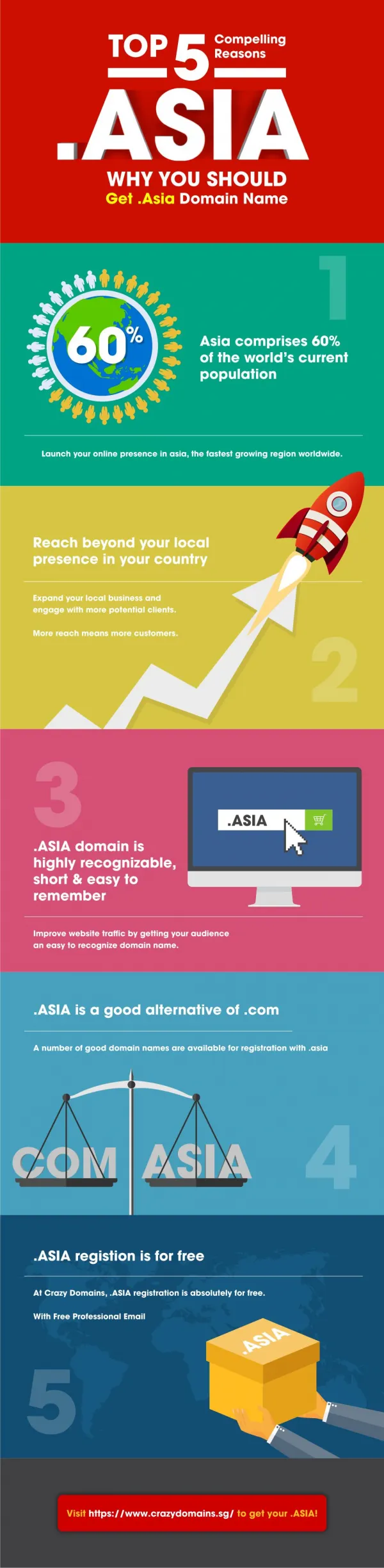
South Asia:. And the study of its physical geography, climate, and vegetation. . Brain Breakfast : Excuse me , d id s omeone o rder r azor s oup ?. Question 1 : The worlds tallest mountain/peak is in the Himalaya Mountain Range, name this mountain/peak and how tall it might be. Answer 1:

E N D
South Asia: And the study of its physical geography, climate, and vegetation.
Brain Breakfast: Excuse me, did someone order razor soup? • Question 1: The worlds tallest mountain/peak is in the Himalaya Mountain Range, name this mountain/peakand how tall it might be. • Answer 1: • Question 2: There are 2 island countries/nations and 5 continental countries/nations that make up South Asia, name them. • Answer 2: • Question 3: South Asia is about ___ the size of the continental ______ ______ . • Answer 3:
The Himalayan Mountain Range: Including Mount Everest The Himalayan Mountain Range Mount Everest
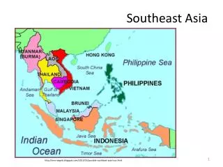
South Asia: The Nations http://www.dailymail.co.uk/sciencetech/article-2109245/Were-going-need-bigger-net-Photographer-meets-FOOT-WIDE-moth-Himalayas.html?ITO=1490/ http://web.worldbank.org/WBSITE/EXTERNAL/COUNTRIES/SOUTHASIAEXT/0,,menuPK:158850~pagePK:146748~piPK:146812~theSitePK:223547,00.html
South Asia: A Land of Varied Landscapes • South Asia is a subcontinent, or a large, distinct landmass that is joined to a continent. • Forms a peninsula touched by three bodies of water: • 1) the Arabian Seato the west. • 2) the Indian Ocean to the south. • 3) the Bay of Bengal to the east.
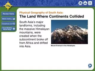
The Himalaya: And other northern landforms • 60 million years ago the Earth had one super landmass! • South Asiawas connected to Africa until it began to break away. • Indian subcontinent collided with South Asia and the Himalayan Mountain Range was formed. • Himalaya: Spreads more than 1,000 miles across the Indian subcontinent.
The Himalaya: And other northern landforms cont’d. . . • To the north: • The Himalayameet the Karakoram Mountains in the northernmost part of South Asia. • To the west: • HinduKushmountains complete the range. • Khyber Pass: A narrow region between Afghanistanand Pakistan that allowed northern invaders to enter the Indian subcontinent.
Central & Southern Landforms • Central Landforms: • The VindhyaRange divides India into northern and southern regions. • The physical separation caused by mountains influence distinct cultures developed in India. • Southern Landforms: • Two chains of mountains located here. • The EasternGhats and the WesternGhats. • Together, a triangle of rugged mountains are formed.
Southern Landforms: Cont’d. . . A Contrast with the North • Eastern and Western Ghats continued… • Between lies the DeccanPlateau: Once part of the super continent that broke away and formed the Indian subcontinent. • Karnataka Plateau: South of the Deccan Plateau. • Green hills, spices growing on plantations, wild elephants in the rain forest. • Sri Lanka: • Teardrop island located southeast of India. • Maldives: • Southernmost country in South Asia. • Tiny chain of coralislands.
Major River Systems: • There are three major river systems in South Asia: • 1) The Indus River: “The Cradle of Ancient India” • Waters apple and peachorchards. • Serves as an important transportation route. • 2) The Brahmaputra River: • Forms a delta at the Bay of Bengal. • Serves as an important inland waterwayfor ships. • Provides 50% of Bangladesh’s power through hydroelectricity.
Major River Systems: Cont’d. . . The Ganges River: Most important river in South Asia. Maintains size year round. Alluvial plain: An area of fertile soil deposited by rivers and flood waters.
Natural Resources: • 1) Water: • Provides drinking water, fertile soil, hydroelectricity, and transportation • Chhukha Hydel hydroelectric project: Bhutan. • 2) Energy Resources: • Petroleum reserves. • Natural gas. • Uranium deposits.
The Chhukha Hydroelectric Project Began construction in the mid 1970’s and completed in 1986
Natural Resources: Cont’d. . . • 3) Minerals: • India: • The worldsleading producer of iron ore. • 90% of the worlds mica: a layered rock used in making electrical equipment. • Sri Lanka: • One of the worlds largest producers of graphite: used for “lead” in pencils. • 4) Timber: • Important natural resource in South Asia. • Overcuttingleads to soil erosion. • Many South Asian nations have banned timber exports.
South Asia: And its climates. . . • Tropical and Subtropical Climates: • Tropical rain forest climates: • Western India and near the GangesDelta. • Ebony Trees, lush vines, and orchids. • The Sundarbans: A swampy area in Bangladesh with the worlds largest protected mangrovepopulation. • Tropical savanna climates: • Central India and eastern Sri Lanka. • Grasslands that experience wet and dryseasons.
South Asia: Climates cont’d . . . • Humid subtropical climates: • Temperate mixed forests. • Located in Nepal, Bhutan, Bangladesh. • Highlands climates: • Coldest climate region. • Little vegetation at high elevation. • Bamboo covers the Himalayan foothills. • Dry climates: • Arid and windswept. • Desert scrub, thorny trees, little grasses. • Much remains a wasteland.
Monsoons • Three seasons: • Hot: February – June. • Wet: June/July – September. • Cool: October – late February. • Seasons depend on monsoons: • Cool season:Monsoon winds blow from the north. • Hot season: Ocean air from the south brings monsoon winds. • Cyclones: A storm with high winds and heavy rains.
Interesting Resources • http://www.stumbleupon.com/su/27Y6lk/www.lib.utexas.edu/maps/historical/india_1882.jpg/ (Ancient India)