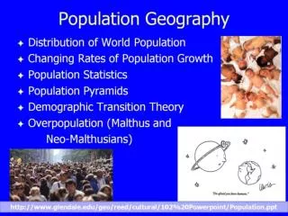
Population Geography
Explore how environmental, economic, and political factors influence population distribution and growth rates. Learn about push and pull factors of immigration, spatial divisions, urban development, and cultural interactions.

Population Geography
E N D
Presentation Transcript
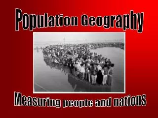
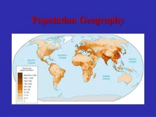
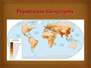
Population Geography WG.5, 6, 10a, 11a-c
What factors influence population distribution? • Environmental factors-- • What type of natural resources are in the area? Does it have oil, or arable land or access to water? • What is the climate like? • Does it have capital resources such as transportation and technology?
Economic factors-- • What is the economic development like? • What are the resources like? • Political factors-- • What is the government policy? • Are there many conflicts? • Is it a rural/urban area?
What are the characteristics of human populations? • Birth and Death rates- • How many people per 1000 are born or die in a year? • Age Distribution-- • How many people are in each age category?
Male/Female distribution-- • Are there more males or more females? Why? • Life Expectancy-- • How old can you expect to live? • Infant Mortality-- • How many children die before their second birthday?
Urban /Rural-- • Where do most people live? In the city/country? • GDP-- • Is the country’s GDP high or low? • Ethnicity-- • Does the population have one dominate ethnicity or many and do they get along?
Language-- • Do the people speak one language or do they have multiple languages? • Religion-- • Do the people share the same religion or do they have multiple ones? • Education-- • Are the people highly educated?
What factors influence population growth rates? • Does the country have modern medicine and hygiene practices? • What is the level of the average education? • Is the country industrialized and do the people live in urban areas?
What is the level of economic development? Does the country have a primary, secondary, or tertiary economy? • What is the government’s policy toward growth? Are there any restrictions? • What role do women play in the society?
Push factors of immigration • Push factors are factors which force people to move. • Overproduction • religious persecution • lack of job opportunities • agricultural decline • conflict
Political persecution • Natural hazards--droughts, floods, famines, volcanic eruptions • Limits on personal freedom • environmental degradation (decline)
Pull factors of immigration • Pull factors attract people to an area • Religion • Economic opportunity • Land availability • Political freedom
Ethnic and family ties • Arable land
What is the impact of migration on regions? • Language--multiple languages • Religion and religious freedom • Customs/traditions--exchanged • Cultural landscape--diffusion • Diffusion--is the spreading of ideas and traits
What is some evidence of culturalinteraction? • The spreading (diffusion) of US culture to other regions of the world • popularization of other cultures’ traditions in the US
Spatial Divisions as Forces of Conflict and Cooperation Spatial divisions are regions of the Earth’s surface over which groups of people establish social, economic and political control. Spatial divisions may generate conflict and/or cooperation.
Examples of Spatial Divisions • Neighborhoods
Reasons for Spatial Divisions Why are spatial divisions necessary at the local and regional levels? 1) Desire for government to be closer to home; 2) need to solve local problems and 3) need to administer resources more efficiently
Reasons for Conflict • How do spatial systems generate conflict? • 1) Citizens may argue over boundaries; 2) Citizens may have low tolerance for different cultures;
3) Citizens may fight/compete over scarce resources and 4) Citizens and/or politicians may try to gain political advantage
Political Advantage? • Yes, spatial divisions can be created in order to manipulate an electoral area, usually by altering the boundaries. This is known as gerrymandering. This is done to gain an unfair political advantage in an election.
Reasons for Cooperation 1) Natural disasters 2) Economic advantages (attracts new businesses) 3) Cultural similarities—ethnic backgrounds 4) Addressing regional issues like waste management, magnet schools and transportation.
Urban Development • Urbanization, or the growing of cities, was triggered by industrialization. • Patterns of urban development occur according to site and situation.
Site and situation • Site and situation are important geographic concepts when studying the growth of cities. • Site is the actual location of a city.
Situationis another name for relative location—the location of a city with respect to other geographic features, regions, resources, and transport routes.
Site • Harbor Sites: NY City, Alexandria, Egypt; Istanbul Turkey • Island sites: Paris, Hong Kong, Singapore • Fall line sites: Richmond, VA • Confluence sites: Khartoum, Sudan; Pittsburg, PA
Hilltop sites: Rome, Athens, Jerusalem • Oasis Sites: Damascus, Syria • Sites where rivers narrow: London, Quebec City
Situation • Istanbul—Command of straits and land bridge to Europe • Mecca, Saudi Arabia; Varanasi (Benares), India—Focal point of pilgrimage • Samarkand, Uzbekistan; Xi’an, China; Timbuktu, Mali; Singapore—Cities that grew up around trade routes
Capetown, S.Africa—Supply station for ships • Omaha, Nebraska; Sacramento, California—Cities that grew up along the U.S. Transcontinental railroad • Novosibirsk,Vladivostok-Cities that grew up along the Trans-Siberian Railroad
Functions of towns and cities • Security and defense • Religious centers • Trade centers (local and long distance • Governmental administration • Manufacturing centers • Service centers
Examples of a city changing functions over time • Rio de Janeiro—was the capital but now is a tourist attraction (Brasilia) • Pittsburgh, Pennsylvania—early function was for frontier defense, then shifted to steel manufacturing, and now is the home to many diverse services
New York City—has changed from a center of coastal and transatlantic trade to a center for the Great Lakes and Erie canal region to worldwide trade and finances • Mining towns– once the resources were gone, many towns became “ghost towns”
What influence does urban areas have on their region and country? • They are the home to monuments which help bring pride and develop nation-building. • They are transportation and communication centers. • They are natural attractions for immigrants.
They are the seed beds for new ideas and technologies. • Their diversity helps lead to creativity in the arts. • Many are the home to major Universities which provide educational opportunities.
They are the headquarters and regional outposts of major corporations. • The major media outlets have their centers there (newspapers, radio, and television).
What problems are associated with growth of urban areas? • Transportation problems, especially since the automobile. • Rich and poor neighborhoods are usually isolated from one another. • As overcrowding occurs, providing essential services (water, sewage, electricity) is a problem.
Air, water, and noise pollution • Sprawl (spreading) of urban areas takes agricultural land out of production. • Rapid migration results in “shantytowns” on the edge of Latin American, Asian, and African cities.
In developing countries, major cities are more connected to the outside world than to less developed regions in their own countries