Download
1 / 27
270 likes | 594 Vues
Severe Weather Forecasting and Warning Services in Nepal Rajendra P . Shrestha Meteorological Forecasting Division Department of Hydrology and Meteorology.

E N D
Severe Weather Forecasting and Warning Services in NepalRajendra P. ShresthaMeteorological Forecasting DivisionDepartment of Hydrology and Meteorology Severe Weather Forecasting Demonstration Project Regional Subprojects for the Bay of Bengal and for Southeast Asia – Training Workshop on Severe Weather Forecasting and Warning Services Macao, China 8-19 April 2013
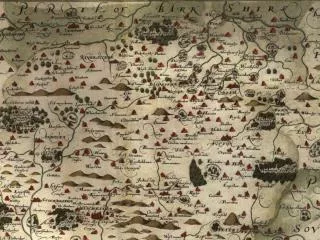
Location of Nepal • South Asian landlocked country with fascinating topography and climate. • It lies between 26022’to30027’N lat and 84004’to 88012’E long. • Area: 1,41,741 sq km. • Highest elevation: 8848 m • Lowest Elevation: 64 m
D KTM China Physiographic view of Nepal India
Mt. Everest 8848m 15% 60 m 68% 17%
Physiographic Regions based on Topography and 15 Synoptic Stations • Terai (60-200)M ,17%, • Churia, ( Siwalik Range) (200-1500)M • Middle Mountain (Mahabharat range) (1200-2500)M,68% • High Mountain (2500-4000)M • High Himalayas (4000-8848)M 15%
Forecasting Method • Persistence method (synoptical, climatological) • Model products by WRF • (NWP ECMWF, IMD Model Charts, NCEP’s Climate Prediction Center (CPC) etc.) • Site-specific forecasts for surface weather parameters (EPSgrams) for specified locations (up to 10 stations of country) • Satellite images are used
10 locations (synoptic stations) for which the ECMWF would provide EPSgrams for Nepal
Dissemination systems • DHM is issuing on daily basis public weather bulletins twice a day to the public through internet.(mfd.gov.np) • Disseminate the special bulletin to higher authorities by using fax, phone, mobile phones etc. if required. • Through media (Both print and e-media) • National Disaster Management • NGO and INGO
Future Plan • Installation of AWS in all synoptic stations under SAARC_STORM project. • One Doppler Weather Radar probably next year • Two GPS Sonde Stations • 16 telemetry rainfall stations will be installed in model basin. • Pilot Program for Climate Resilience (PPCR) is going to commence next year to modernized and development in existing system.