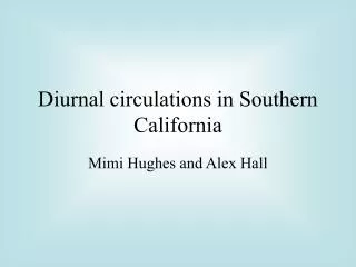
ESYS 150 LECTURE 9 TRANSFORM FAULT EARTHQUAKES IN SOUTHERN CALIFORNIA
ESYS 150 LECTURE 9 TRANSFORM FAULT EARTHQUAKES IN SOUTHERN CALIFORNIA. Transform Fault Earthquakes Earthquake Prediction Thrust Earthquakes around Transforms San Diego County Earthquakes. NORTH AMERICA 38MA - PRESENT DEVELOPMENT OF SAN ANDREAS FAULT.

ESYS 150 LECTURE 9 TRANSFORM FAULT EARTHQUAKES IN SOUTHERN CALIFORNIA
E N D
Presentation Transcript
ESYS 150LECTURE 9TRANSFORM FAULT EARTHQUAKES IN SOUTHERN CALIFORNIA Transform Fault Earthquakes Earthquake Prediction Thrust Earthquakes around Transforms San Diego County Earthquakes
NORTH AMERICA 38MA - PRESENTDEVELOPMENT OF SAN ANDREAS FAULT
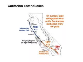
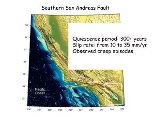
TRANSFORM FAULT EARTHQUAKESSAN ANDREAS FAULTCape Mendocino to Gulf of California Coast line in blue. San Andreas fault heavy dark line.Very complex system of faults especially in southern California.
TRANSFORM EARTHQUAKESLOCKED SECTIONS1857 Fort Tejon and 1906 San Francisco Two sections of the fault locked for long periods of time. Then gave way very quickly creating two major ruptures Fort Tejon 360 km long San Francisco 430 km long. Two very large earthquakes
TRANSFORM EARTHQUAKES1906 SAN FRANCISCOLocked section moved Moved 6m along 430 km of fault. Had 60 secs of shaking. Magnitude 7.8 earthquake Most damage due to fire and disease. Important for developing elastic rebound theory for earthquakes
TRANSFORM EARTHQUAKES1989 LOMA PRIETADuring World Series Bend of San Andreas, where two faults split off from main fault, ruptured. Earthquake did not rupture the ground. Moved 1.9 m horizontally and 1.3 m vertically. Magnitude 6.9 Caused a lot of damage in San Francisco.
TRANSFORM EARTHQUAKESLOMA PRIETA 1989Damage in Marina District San Francisco • Water saturated sediments were shaken became a slurry and flowed. Foundations collapsed especially soft buildings. (b) Bottom floors used for garaging cars collapsed.
TRANSFORM EARTHQUAKES1989 LOMA PRIETAInterstate 880 collapse Portion of the elevated 880 built on soft mud. The soft mud resonated with the earthquake waves and the mud liquified. The hard rock had much smaller accelerations
TRANSFORM EARTHQUAKES1989 LOMA PRIETAInterstate 880 collapse The bridge had roughly the same frequency as the amplified surface waves and shook severely. The support columns failed at the joints. There were 20 #18 steel bars in the columns but they were discontinuous at the joints. With repeated shaking the joints failed and the bridge collapsed.
EARTHQUAKE PREDICTIONHOW FAULTS WORKElastic rebound theory • Active fault with road as reference. • Deformation occurs either side of the fault but because of friction at the fault, no movement • Deformation so great fault ruptures and two side snap away from each other. Current models add propagation of fault break. Like a ripple on a carpet.
EARTHQUAKE PREDICTIONPALEOSEISMOLOGYSag ponds Topography along the central San Andreas Sag ponds - down dropped areas along the fault. Sediments deposited allow the prehistoric record to be read.
EARTHQUAKE PREDICTIONPALEOSEISMOLOGYResults from trenching Diagram of section across a trench wall. A fault has offset the sediment layers. No offset since upper layer of organic material formed. The 500 year old layer is offset and 745 year old layer is offset twice as much.
EARTHQUAKE PREDICTIONSEISMIC GAPSCross section of seismicity, San Andreas 1969 to 1989 • Dense cluster in central creeping section of the fault. • 1989 Loma Prieto earthquake and after shocks filled in a gap Gap exists south of San Francisco.
EARTHQUAKE PREDICTIONPREDICTION FOR SAN ANDREAS Prediction of magnitude and probability of occurring before 2030. Forecasts based on historic records, dated trench wall offsets and gps
THRUST QUAKES SAN ANDREASBEND IN SAN ANDREASComplex plate pattern south of bend Left stepping right lateral fault creates compression at the bend Leads to many little plates south of the bend. Compression creates the Transverse Ranges and the San Gabriel Mts. Have thrust faults under LA.
THRUST QUAKES SAN ANDREASBLIND THRUSTSSan Fernando 1971, Northridge 1994 Blind thrusts close together but dipping in opposite directions 1994 Northridge on Pico Fault dipping to the south. Overthrust plate moved up 3.5 m Intense ground shaking in cities on overriding plate. 1.8 g horizontal accel. 1.2 g vertical accel.
THRUST QUAKES SAN ANDREASTHE BIG ONEComparison with 1957 Mongolian quake Comparison at same scale of Gobi-Altay Mongolia and San Andreas Offsets on faults are similar and both have regions of thrust faults. Whole Mongolian fault system went in 1957. > 8. Magnitude
SAN DIEGO COUNTY EARTHQUAKESMAJOR FAULTS San Andreas 30 mm/yr San Jacinto 12 mm/yr Elsinore 5 mm/yr Newport/Inglewood /Rose Canyon 2 mm/yr
SAN DIEGO COUNTY EARTHQUAKESHISTORICAL EARTHQUAKES 1800 damaged San Diego Mission, 6.5 M 1862 damaged town, Rose Canyon Fault, 6.0 -7.0 M 1892 Laguna Salada Fault (extension of the Elsinore), > 7.0 M 1933 Long Beach earthquake on extension of Rose Canyon Fault. Very damaging earthquake, affected schools
SAN DIEGO COUNTY EARTHQUAKESROSE CANYON PLAN VIEW Freeways (red) Rose Canyon Fault (black) Separates La Jolla, Pacific Beach and Point Loma from the rest of San Diego. Portions of Interstate 5 run down the fault. It runs out to sea off Coronado
SAN DIEGO COUNTY EARTHQUAKESROSE CANYON FAULT & MOUNT SOLEDAD Uplift of Mount Soledad created by left step in a right lateral fault. La Jolla/Cabrillo block is running into a bend in fault and being compressed creating uplift.
SAN DIEGO EARTHQUAKESTRENCHING STUDY ROSE CANYON FAULT Site was located in the SDG&E parking lot. Right by Interstate 5 Where active section of Rose Canyon fault is known to run. Used pre War II air photo’s to locate the fault.
SAN DIEGO EARTHQUAKESTRENCHING IN ROSE CANYON FAULT Southward view of hand-excavated trench. Fault strikes from upper left to lower right corner
SAN DIEGO EARHQUAKESPLAN VIEW OF ACTUAL TRENCH Grey shows area dug out to a depth of 2 m. Dashed lines show strands of the fault. The redline shows buried channel offset across the Rose Canyon Fault
SAN DIEGO EARTHQUAKESMAP AND RECONSTRUCTION OF CHANNEL Total offset 8.7 m Age of channel 8.1 - 6.0 Kyr Slip rate 2.0 to 1.1 mm/yr Three major offsets suggests recurrence rate 2 - 3 Kyr for M 6.3 events Last event 500 yrs BP
SAN DIEGO COUNTY EARTHQUAKESCOASTAL FAULT ZONE Paleoseismic motions on the Coastal Fault Zone with dates of most recent rupture. Note the northward propagation of the events. All except 1933 Long Beach earthquake were determined from trenching.