Download
1 / 14
140 likes | 264 Vues
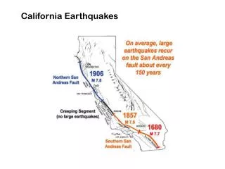
This study delves into the active faults, significant earthquakes, magnitudes, depths, and historical trends of seismic activity in Southern California. The research focuses on key events like the Landers and Hector Mine earthquakes.

E N D
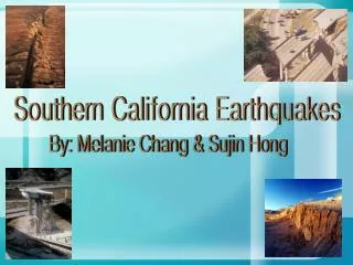
Southern California Earthquakes By: Melanie Chang & Sujin Hong
Abstract First, all the active faults in Southern California, such as the San Andreas and the San Jacinto faults, were examined. Then, the fault lines were displayed via a 3D imaging program called Fledermaus. Afterward, the most significant earthquakes that occurred on each fault were studied. The data showed that the largest recorded earthquakes in Southern California were the Landers earthquake and the Hector Mine earthquake. Lastly, the magnitudes and depths of each earthquake since 1982 were reseached and plotted.
Southern California Fault Map Key for the Faults SA = San Andreas Rn = RinconadaHos = HosgriSJ = San JuanOz = OzenaBP = Big PinePM = Pine MountainSY = Santa YnezSC = San CayetanoSS = Santa SusannaOak = OakridgeMC = Malibu CoastSM = Santa MonicaSN = Sierra NevadaWW = White WolfGar = GarlockBw = BlackwaterHa = HarperLck = LockhartHel = HelendaleLn = LenwoodCal = CalicoPs = PisgahLud = LudlowBul = BullionPtM = Pinto MountainBlu = Blue CutSG = San GabrielSiM = Sierra MadrePV = Palos VerdesN-I = Newport-InglewoodWh = WhittierSJc = San JacintoBan = BanningHS = Hot SpringsEls = ElsinoreSsH = Superstition HillsSsM = Superstition MountainImp = Imperial
Total Number of Earthquakes • 57,973 total earthquakes from 1982-2005 • 49 earthquakes >M5 • 8 earthquakes > M6 • 2 earthquakes >M7 • The two earthquakes greater than M7 were the Hector Mine and Landers earthquakes
Date of Earthquakes vs. Magnitude of Earthquakes • The magnitudes of most earthquakes are within the range of 0-4 • As the years progress, more earthquakes are recorded as technology improves
Magnitudes Magnitudes M (3-4) M (1-3) M (4-5) M (7-8) M (6-7) M (5-6)
Date of Earthquakes vs. Depth of Earthquakes • 1977-1988: the earthquakes were all between the depths of 17-21 km • 1988: the deepest earthquake occurred • After 1988, depths dropped • 1999: depths rose again due to the Hector Mine earthquake
Years Years 1986-1990 1982-1985 2001-2005 1991-1995 1996-2000
Major Southern California Earthquakes Hector Mine Earthquake (1999) Magnitudes M (1-3) M (3-4) M (7-8) M (4-5) Landers Earthquake (1992) M (6-7) M (5-6)
Landers Earthquake • Struck on the eastern side of the San Bernardino Mountains at 4:57 A.M on June 28, 1992 • Magnitude of 7.3 • Largest earthquake to hit Southern California since the Kern County earthquake in 1952 with a magnitude of 7.7 • The type of faulting was right-lateral strike-slip • One person killed, 25 people seriously injured, 372 people treated for earthquake related injuries • Total property damage value was about $56 million • Occurred on the Lenwood fault
Hector Mine Earthquake • Occurred 2:46 A.M on Saturday, October 16, 1999 • The largest earthquake since the M7.3 Landers earthquake • Occurred on the Calico fault • Magnitude 7.0 • Only lasted about ten seconds • The type of faulting was a right-lateral strike-slip
Conclusion In conclusion, Southern California is located on one of the most active faults, the San Andreas Fault. Also, the largest earthquakes ever to occur in Southern California are the Landers (1992) and Hector Mine (1999) earthquakes. Although we do not know when the big one will hit Southern California, our technology will keep improving to make our cities safer and to make sure everyone is prepared.
Works Cited • http://geology.about.com/library/weekly/aa111499a.htm • http://seismo.berkeley.edu/annual_report/ar99_00/node20.html • http://www.scienceblog.com/community/older/2003/A/20035955.html • http://earth.esa.int/applications/data_util/SARDOCS/spaceborne/Radar_Courses/Radar_Course_III/landers_earthquake_south_california.htm • http://quake.usgs.gov/info/listen/combination.htmlhttp://www.nature.com/nature/journal/v411/n6836/abs/411462a0.html • http://www.everything2.com/index.pl?node_id=1322804
Acknowledgements: We would like to thank our instructors, Dr. Benson Shing, Bridget Smith, & Andreas Stavridis for teaching us about the structures during earthquakes and geophysics of earthquakes, Jon Deck and Allison Jacobs for helping us every step of the way, and our teacher fellow, Jerry Lederman, for always being there for us. The End