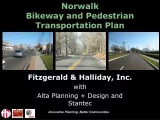
Norwalk Bikeway and Pedestrian Transportation Plan
Norwalk Bikeway and Pedestrian Transportation Plan Fitzgerald & Halliday, Inc. with Alta Planning + Design and Stantec Presentation agenda Plan overview Current conditions Opportunities Vision Next steps Plan overview Directed by Planning and Zoning Department Select consultants

Norwalk Bikeway and Pedestrian Transportation Plan
E N D
Presentation Transcript
Norwalk Bikeway and Pedestrian Transportation Plan Fitzgerald & Halliday, Inc. with Alta Planning + Design and Stantec Innovative Planning, Better Communities
Presentation agenda • Plan overview • Current conditions • Opportunities • Vision • Next steps Innovative Planning, Better Communities
Plan overview • Directed by Planning and Zoning Department • Select consultants • Fitzgerald & Halliday, Inc. • Alta Planning + Design • Stantec Innovative Planning, Better Communities
Plan purpose • Ten year guide map • Identify issue areas • Develop list of priorities • Rank priorities • Develop conceptual plans • Develop Bikeway and Pedestrian Plan • Design guidelines • Identify bicycle and pedestrian network Innovative Planning, Better Communities
Involvement • City departments • Redevelopment Agency • Merchant groups • Major employers • Developers • Sound Cyclists • Norwalk River Valley Trail • Merritt Parkway Trail Alliance • Cultural institutions • Schools • Residents/Neighborhood Innovative Planning, Better Communities
Project components • Existing conditions • Identify missing links • Baseline conditions/ benchmarking • Recommendations • Design schematics • Design standards • Ten-year plan • Vision • System identification • Funding needs Innovative Planning, Better Communities
Work to date • Focus group meetings • Review past reports • Plan of Conservation and Development • Connectivity Plan • Various neighborhood /district plans • Regional and statewide bicycle and pedestrian plans Innovative Planning, Better Communities
What is Norwalk? • Neighborhoods • Employment center • Retail and dining center • Tourist attractions • Transportation hub Innovative Planning, Better Communities
What can Norwalk be? • A great place to live • A great place to work • A great place to walk, shop and eat • A great place to visit • A place that is livable and connected Innovative Planning, Better Communities
Existing conditions • Thriving retail and commercial areas • Dense residential development and neighborhoods • Extensive sidewalk network • Series of linear paths and plans • Planned development projects • On-going train station improvements Innovative Planning, Better Communities
Potential demand • Approximately 83,185 residents • 17,865(21%) peoplelive/work in Norwalk • 11% of residents commute by public transit • 6.5% of households do not own cars YET… • Less than 5% walk or bike to work Innovative Planning, Better Communities
Increasing bicyclist – decreasing injuries 66% increase in cycling in last two years Innovative Planning, Better Communities
Livable community Somerville, MA Innovative Planning, Better Communities
Livability indicators • Miles of sidewalks / paths • Mode of travel percentages • Percent walk/bike to work • Percent transit to work • Transit ridership • Trail bicycle counts • Walk/bike to school numbers • Number of bicycle racks • Bicycle and pedestrian Level of service Innovative Planning, Better Communities
Complete streets • Examine existing regulations • Review current design guidelines • Work between agencies • Bring residents, merchants, developers together • Safe routes to transit Innovative Planning, Better Communities
Placemaking • Bike boulevards • Bike racks • Signage / striping • Wayfinding program • Lighting • Pavement treatment • Complete missing links Innovative Planning, Better Communities
Road Diet • Typically, a reduction of a four-lane road to two lanes with center turn lane and bike lanes • Provides potential for pedestrian refuge island at unsignalized crosswalks where left turn lane is not needed • Moving left-turning vehicles out of flow of traffic increases safety for ALL users Glisan Street, Portland OR - BEFORE Glisan Street, Portland OR - AFTER
Bike Lanes • Convenience of riding on the street with some psychological separation • Novice cyclists are more likely to ride in bike lane rather than the sidewalk • Street appears narrower - motorists drive slower Commonwealth Avenue, Boston - BEFORE Commonwealth Avenue, Boston - AFTER
Bike Boxes – Increase Visibility Hawthorne Boulevard, Portland OR
Buffered Bike Lanes • Convenience of riding on the street + psychological separation of a barrier • Mountable curb allows cyclists to leave bike lane for turning or overtaking • Motorists feel bump when they stray into curb • Novice bicyclists more likely to ride in bike lane rather than on sidewalk mountable curb
Two-way Cycle Track Montreal Cycle-track: a path for bicyclists located next to (alongside) a roadway. A sidepath is similar to a sidewalk, but designated for anyone traveling by bicycle Kelowna, BC Hudson River Pathway, West Side, NYC
Shared Lane Markings: “Sharrows” Sharrows: roadway marking installed in travel lanes. This marking is used within travel lanes shared by bicyclists and other vehicles. The name "sharrow" was coined by Oliver Gajda, of the City and County of San Francisco Bicycle Program, as a combination of shared lane and arrow. Portland, OR Somerville, Mass
Bicycle Parking – On-street bike corrals Portland OR Portland OR
Streetscape Improvements Tremont Street, Boston - BEFORE Tremont Street, Boston - AFTER
Streetscape Improvements Winthrop Street, Cambridge - BEFORE Winthrop Street, Cambridge - AFTER
Crosswalks/Intersection Treatment Innovative Planning, Better Communities
Crosswalks/Intersection Treatment Innovative Planning, Better Communities
Wayfinding - Signage NY Bike Routes • Directs users to and along trails/paths/bikeways • Directs users to places of interest, giving distance and average cycling time • Visual queue to motorists to be aware of bicycles • Placed at key intersections and decision points Portland, OR
DRAFT Vision All Norwalk residents and visitors have access to the benefits of walking and cycling. They are physically active and they and their children have learned to safely walk and bike, giving them mobility and independence. Norwalk is a community where people can walk or ride from their home to work, transit, to places for shopping and entertainment and for recreation. Norwalk’s streets are livable places that accommodate many activities. Neighborhood business districts are thriving with foot traffic from residents and visitors. A civic commitment to share the road is respected by drivers, cyclists, and pedestrians alike. Norwalk is the hub of a connected regional bicycle network that includes bike lanes, multi-use paths and greenways. Innovative Planning, Better Communities
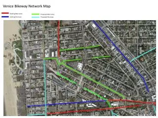
Potential Priority Areas East Avenue The Green Calf Pasture Beach Road Seaview Avenue Strawberry Hill Avenue High pedestrian/bicycle accident locations Innovative Planning, Better Communities
Types of Recommendations Multi-use pathways Signage Sharrows- shared bicycle travel lane markers Bicycle lanes Cycletracks- separated bicycle facilities Crosswalks Overall bicycle and pedestrian network Innovative Planning, Better Communities
Project design concept sample Innovative Planning, Better Communities
Linkages- Harbor and River Trail Naugatuk River Trail, Waterbury, CT East side of Norwalk Harbor Innovative Planning, Better Communities
Potential Recommendations Maps/Tourism brochures Education programs Learn to bike Group walks/bikes Safe Routes to School education Enforcement Design standards Review of ordinances Innovative Planning, Better Communities
Next steps Identify priorities Infrastructure Amenities Regulations/Policies Rank priorities Develop concepts Develop draft plan Public meeting Innovative Planning, Better Communities
On-line survey Link from Department of Planning and Zoning webpage: http://norwalkct.org/CityDept/planzon.asp Innovative Planning, Better Communities
Contact Information Dori Wilson- Norwalk Planning and Zoning Department (203) 854-7954 dwilson@norwalkct.org Ken Livingston- Project Manager- Fitzgerald & Halliday, Inc. 860-247-7200 klivingston@fhiplan.com Innovative Planning, Better Communities