Topology Cleanup
MONUMENTS. LANDSCAPE. MonumentID Mnumber Name Type Datum Easting Northing Elevation LandscapeID HardscapeID BuildingID MSLINK MAPID. LandscapeID Type Easting Northing BuildingID MSLINK MAPID. There is a geometry error (undershoot) in the corner of the building. HARDSCAPE.

Topology Cleanup
E N D
Presentation Transcript
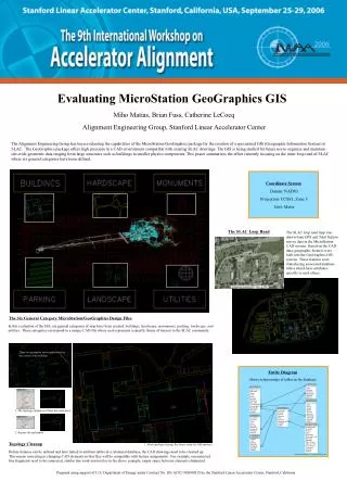
MONUMENTS LANDSCAPE MonumentID Mnumber Name Type Datum Easting Northing Elevation LandscapeID HardscapeID BuildingID MSLINK MAPID LandscapeID Type Easting Northing BuildingID MSLINK MAPID There is a geometry error (undershoot) in the corner of the building HARDSCAPE HardscapeID Type Name Length Width Easting Northing BuildingID ParkingID MSLINK MAPID 1. The topology cleanup tool finds the undershoot BUILDING_INFO BuildingInfoID Bnumber Bname Type Bmanager Bmanager_dept Bdivision Blocation Mgr_Division Mgr_Assistant Asst_Division Comments MSLINK MAPID PARKING ParkingID PLname Type Row Easting Northing BuildingID MSLINK MAPID 2. Repairs the undershoot UTILITES UtilityID Type Easting Northing BuildingID MSLINK MAPID Evaluating MicroStation GeoGraphics GIS Miho Matias, Brian Fuss, Catherine LeCocq Alignment Engineering Group, Stanford Linear Accelerator Center The Alignment Engineering Group has been evaluating the capabilities of the MicroStation/GeoGraphics package for the creation of a specialized GIS (Geographic Information System) at SLAC. The GeoGraphics package offers high precision in a CAD environment compatible with existing SLAC drawings. The GIS is being studied for future use to organize and maintain site-wide geometric data ranging from large structures such as buildings to smaller physics components. This poster summarizes the effort currently focusing on the inner loop road of SLAC where six general categories have been defined. Coordinate System Datum: NAD83 Projection: CCS83, Zone 3 Unit: Meter The SLAC Loop Road The SLAC loop road map was drawn from GPS and Total Station survey data in the MicroStation CAD system. Based on the CAD data, geographic features were built into the GeoGraphics GIS system. These features were linked using associated database tables which have attributes specific to each object. Orthophotos created in 2001 Scale: ~1:3500 The Six General Category MicroStation/GeoGraphics Design Files In this evaluation of the GIS, six general categories of map have been created: buildings, hardscape, monuments, parking, landscape, and utilities. These categories correspond to a unique CAD file where each represents a specific theme of interest to the SLAC community. Entity Diagram Shows relationships of tables in the database 1 1 BUILDINGS 1 1 BuildingID Bnumber Easting Northing Area Perimeter BuildingInfoID MSLINK MAPID 1 Topology Cleanup 3. After topology cleanup, the data is ready for GIS analyses. Before features can be defined and later linked to attribute tables in a relational database, the CAD drawings need to be cleaned up. This means correcting or changing CAD elements so that they will be compatible with feature assignments. For example, unconnected line fragments need to be connected, similar line work removed or in the above example, empty space between elements eliminated. *BUILDING_INFO table is non-graphic attribute data Prepared using support of U.S. Department of Energy under Contract No. DE-AC02-76SF00515 by the Stanford Linear Accelerator Center, Stanford, California