Topology
Learn about relationships and issues in GIS data topology, how to integrate datasets properly, and fix common problems like gaps and slivers. Follow step-by-step instructions and best practices for editing and validating GIS data.

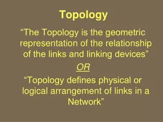
Topology
E N D
Presentation Transcript
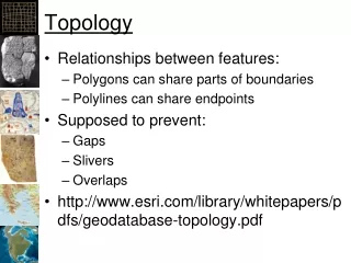
Topology • Relationships between features: • Polygons can share parts of boundaries • Polylines can share endpoints • Supposed to prevent: • Gaps • Slivers • Overlaps • http://www.esri.com/library/whitepapers/pdfs/geodatabase-topology.pdf
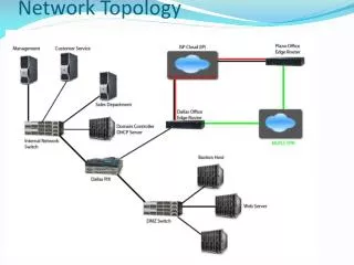
Topology Wyoming Colorado
Non-Topological Wyoming Colorado
Topological Wyoming Colorado
Problems without Topology • Common problems: • Slivers • Gaps • Caused by: • Reprojecting • Different sources • Editing or digitizing without snapping • Any tool that changes the values of coordinates in vector data
Gaps and Slivers • Gaps and slivers appear when operating on datasets that have topological errors Gap Sliver
Levels of Topological Control • No Control • Snapping with manual editing • Topological Rules • GeoDatabase • Fixing large numbers of errors • GeoDatabase • Topological Structure • Only available in coverage's which are going away!
Snapping • Turn on snapping! • Task: Modify Edge • Tool: • Move first edge • “Snap” second edge to first
Editing Topological Structures • Open the topology tool bar • Task: Modify edge • Tool: Topology Edit Tool • Click on the vertex to edit • Drag to new location
New Polygons • Turn on Snapping! • Task: Auto Complete Polygon • Tool: Sketch Tool • Click to start polygon on existing edge • Click for each new point • Click back on old boundary to complete Note: Remember to check task, target, and folder we are editing in
Topologies in GeoDatabases • Live within Feature Dataset • Can have multiple per dataset • Can affect multiple feature classes • Each feature class can be in only one topology Note: All feature classes in a feature dataset must have the same spatial reference
Fixing Many Topological Errors • The following procedures will allow you to remove large numbers of overlaps and gaps when merging datasets • The instruction must be followed closely • Notes: • You cannot create or edit topologies when ArcMap is open if it has contained the layers • You cannot use ArcToolbox functions during an edit session (bad things happen) • You cannot delete a Feature Class that is participating in a Topological Class • Only one topology problem can be removed at a time
Fixing lots of overlaps • Merge the shapes into a single Feature Class in a GeoDatabase using ArcToolbox -> Data Management Tools -> General -> Merge • Create a new Topology for the Feature Class with the rule “Must not overlap” • Validate the Topology • Load the Topology into ArcMap with it’s associated feature class • Start an edit session • Click on the Map Topology icon in the Topology task bar • Select the merged layer and click OK • Select the layer in the Topology tool bar (it will have been reset) • Select the Fix Topology Error Tool • Select the overlaps • Right click on one of the selected overlaps and select “Create Feature…” • Open the attribute table and select the new features • Set an attribute in the new features to match the same value in the feature they should be merged into (i.e. set the state name to Minnesota) • Make sure you clear the selection AND stop the editing session • Select Toolbox -> Generalization -> Dissolve and dissolve the topology features into one of the main features
Fixing lots of gaps • Follow the instructions for overlaps except select the rule “Must not have gaps” • When selecting features to create only select the gaps that should be filled (not the outside of the boundaries or lakes between shapes) • You will need to close ArcMap to create the topology if ArcMap has had the Features Classes loaded into it
GIS Lessons • Don’t give up! • Keep trying different approaches • Write down what works and what to avoid • Break processes into simple steps • Look for folks who can help • Arc is just a tool – it’s up to you to figure out how to use it to get the task at hand completed • PS: Arc is not the only tool out there
Topology • Cluster Tolerance • Distance that vertices and line segments will be snapped together • Make it about 1/10 the accuracy of the data • Relative ranks for each feature class • Features in classes with larger ranks will be snapped to features in classes with lower ranks • Rules • Must not overlap • Must be contained within
Validating Topology • Dirty areas – have not been checked • Validate Topology • Vertices and boundaries are snapped • Checks data against rules • Marks errors • User can: • Fix errors • Mark as exceptions
Fixing Topological Errors • Gap: • Create Feature • Merge features • Overlap: • Merge... • For lots: • Open "Error Inspector“ • Search for errors • Set a length/area ratio • Anything over 0.2 is probably a sliver (and have higher IDs) • Create features for all • Data Management Tools -> Generalization -> Eliminate • Based on largest shared border
2 Levels of Topology • Within one layer • States share boundary • Streams and roads should meet at ends • Between multiple layers • National Park and Forest share part of a boundary • Interstates join with highway • Park boundary follows the center of a river
Advantages • Makes data consistent • Editing can be done on shared geometries • “Snapping” does the same thing but requires moving both points.