Download

1 / 32
350 likes | 581 Vues
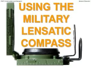
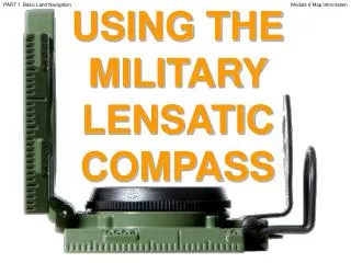
PART 4 Expert Land Navigation. USING THE MILITARY LENSATIC COMPASS. Module 18 Navigating Different Terrain. PART 4 Expert Land Navigation. Module 18 Navigating Different Terrain. WARNING.

E N D
PART 4 Expert Land Navigation USING THE MILITARY LENSATIC COMPASS Module 18 Navigating Different Terrain
PART 4 Expert Land Navigation Module 18 Navigating Different Terrain WARNING This presentation is intended as a quick summary, and not a comprehensive resource. If you want to learn Land Navigation in detail, either buy a book; or get someone, who has the knowledge and skills, to teach you in person.
PART 4 Expert Land Navigation Module 18 Navigating Different Terrain NOTE To get the ideas across presented on these slides, many figures, pictures, and calculations may not be to scale and may be exaggerated for clarity.
PART 4 Expert Land Navigation Module 18 Navigating Different Terrain Note: Prior to being issued any training *equipment, you will be required to sign a “statement of liability” agreeing to pay for anything you damage or lose. All items will be inspected and inventoried prior to your signature and at the end of the training day too. If you do not intend to sign this statement, then you may be denied training. *You may use your own equipment.
PART 4 Expert Land Navigation Module 18 Navigating Different Terrain Any Questions?
PART 4 Expert Land Navigation Module 18 Navigating Different Terrain LAND NAVIGATIONPRESENTATIONPART 4Module 18Different Terrain
PART 4 Expert Land Navigation Module 18 Navigating Different Terrain . . . and now on with the . . . PRESENTATION
PART 4 Expert Land Navigation Module 18 Navigating Different Terrain LAND NAVIGATION WITH MAP ANDLENSATIC COMPASS
PART 4 Expert Land Navigation Module 18 Navigating Different Terrain LAND NAVIGATION • Why Learn Land Navigation? • Tracking present location • Determining Distance • Sense of direction • How to read a topographic map • Terrain and map association • Spatial skills • Planning safe, practical routes • And more Navigational skills • The best way to learnLAND NAVIGATION is to get "dirt time", that is, get out there with a map and compass! • Navigation is not about finding yourself after you are lost (although that’s what happens sometimes); it’s about keeping track of your position as you move away from a known point. As you move you have to remain cognizant of the terrain you are leaving, of the terrain you are passing, and of the terrain that is ahead. • Navigation in the wilderness means knowing your starting point, your destination, and your route to get there. • These skills will allow you to venture farther off the beaten path than you ever thought before. Training and practicing land navigation on foot provides the following everyday navigation (how not to get lost) benefits; (Where am I?) (How far is it and am I there yet ?) (Where do I want to go and where am I actually going ?) (Do I understand the map ?) (What hill or river am I looking at ?) (Can I mentally visualize the landscape in 3D ?) (Take a long safe route or a short risky route ?)
PART 4 Expert Land Navigation Module 18 Navigating Different Terrain • THIS PRESENTATION IS DIVIDED INTO FOUR PARTS • ________________________________________________________________________________________________________________________________________________________ • PART 1 Basic Land Navigation • The Lensatic Compass module 1 • The Topographic Map modules 2, 3, 4, • The Land and Map Association modules 5, 6 • PART 2 Intermediate Land Navigation • Making Sense of Direction module 7 • Tracking Present Location modules 8, 9, 10, 11 • Determining Travel Distance modules 12, 13, 14 • PART 3 Advance Land Navigation • Navigation Methods to Stay On Course module 15 • Additional Skills of Land Navigation module 16 • Planning to Navigate module 17 • PART 4 Expert Land Navigation • Navigation in different types of Terrain module 18 • Night Navigation module 19 • Sustainment module 20
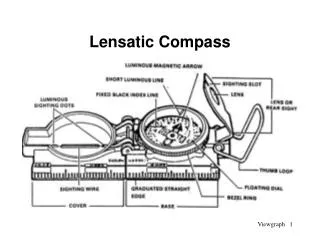
PART 4 Expert Land Navigation Module 18 Navigating Different Terrain THESE ARE THE TRAINING MODULES Module 1 Lensatic Compass – parts and features, and how to sight the compass by two different methods. Module 2 Topo Map Margin – what map margin data represents, map care, and how to properly fold a map. Module 3 Topo Map Scale – map sizes and how it affects amount of detail that will be shown. Module 4 Topo Map Symbols – you must understand them; to read and speak map language to others. Module 5 Terrain Relief – shows elevation, indicates terrain features and heights of natural features. Module 6 Map Information – what a protractor is for and how a map provides four kinds of information. Module 7 Sense of Direction – lateral drift, current bearing, obstacles, back azimuth, deliberate offset. Module 8 Resection – locate position with map only. Modified resection is with a map or compass. Module 9 Intersection & Triangulation – two methods to locate position by compass. Module 10 Map Speaks Compass Language - there is no need to orient the map to find your position. Module 11 Plotting Position Coordinates – exact positioning, used to communicate to others with a map. Module 12 Route Measure – mapping straight-line distance, curvature distance, and slope distance. Module 13 Pace Count – using ranger pacing beads and estimating hiking speed. Module 14 Travel Distance Estimation – estimating by 100 meter rule, rule-of-thumb, and by time. Module 15 Plan to Navigate – in a group or alone, equipment, safety, responsibilities, route selection. Module 16 Stay on Course – advance reference points and advance baselines. Module 17 Additional Land Navigation Skills – estimate daylight, conserve energy, blisters, weather insight. Module 18 Navigating Different Terrain – special environments, featureless terrain, visibility, dense foilage. Module 19 Night Navigation – night adaptation, protecting night vision, navigate with lensatic compass. Module 20 Sustainment – maintaining skills, training others, setting up a land navigation course.
PART 4 Expert Land Navigation Module 18 Navigating Different Terrain Any Questions?
PART 4 Expert Land Navigation Module 18 Navigating Different Terrain PART 4EXPERT LAND NAVIGATION MODULE 18 • Navigation in Different Terrain • Description • Skills
PART 4 Expert Land Navigation Module 18 Navigating Different Terrain NAVIGATING DIFFERENT TERRAINSDESCRIPTION The LAND NAVIGATION information, concepts, and skills already presented in the other lessons will help you to navigate anywhere in the world. However, there are some special considerations and helpful hints that may assist you in various SPECIAL ENVIRONMENTS. Terrains that can be featureless, rough, dense, unpredictable footing or ground, and unpredictable weather/visibility. • Navigating accurately in featureless terrain takes lots of... mental concentration, patience, advanced navigation skills, practice, and experience. • Dead Reckoning • Desert (Mountain, Rocky Plateau, and Sand Dune Deserts) • Jungle • Snow / Arctic • Fog / limited visibility
PART 4 Expert Land Navigation Module 18 Navigating Different Terrain NAVIGATING DIFFERENT TERRAINSDEAD RECKONING • DEAD RECKONING, where azimuth (or direction of travel) data is combined with pacing (or distance traveled) • data. With this technique, one can establish their position in featureless terrain, foul weather, or even in • complete darkness. • DEAD RECKONING is not as accurate as other forms of navigation, but it will suffice, when that is the only • resource available. In theory, Dead Reckoning works. But in reality, not as well, since it is impossible to walk • a straight line, and measuring distance (pace or time) is not precise. • It is an estimated position • It is a good way of not getting lost • It narrows down the area of uncertainty • You are not at your estimated position, just somewhere near it • For short distances, such as a few miles, the cumulative errors are acceptable • The "dead" in dead reckoning is derived from "ded.," an abbreviation of "deduced.“ It's navigation by logical • deduction. It does not necessarily mean it's a deadly form of navigation. • Dead reckoning consists of three fundamental steps. • You begin your journey from a positive fix, a point you are sure of and can locate on the map. • From there you maintain accurate data of distance and direction traveled for each leg of your route, on a sheet of paper. • You then use this data to update your position on the map. • The rules of dead reckoning: Plot your estimated position . . . • Every hour on the hour (30 minutes on the half hour is more accurate) • After every change of direction (azimuth) • After every change of speed (pace)
PART 4 Expert Land Navigation Module 18 Navigating Different Terrain Estimated Position # 4 Estimated Position # 7 Estimated Position # 6 270º 700m 290º 500m Estimated Position # 3 210º 500m 310º 650m 165º 450m 30º 250m Estimated Position # 2 Estimated Position # 5 Estimated Position # 8 95º 500m Finish 345º 400m Estimated Position # 9 Estimated Position # 1 Start 90º 1Km NAVIGATING DIFFERENT TERRAINSDEAD RECKONING Example – you want to explore a prairie / plain with flat terrain. 1. Set compass azimuth and follow it, use the Center-Hold method. 2. Measure distance traveled by pace count, time or other method. 3. When you decide to change direction a. Stop and take out the map. b. Draw a course line out from your start point in the direction you traveled. c. Measure calculated distance on the drawn line equal to the distance traveled. d. Put a “X”, circle, or tick mark - this is your new current ESTIMATED FIXED POSITION. 4. From your new estimated fixed position, repeats the above steps.
PART 4 Expert Land Navigation Module 18 Navigating Different Terrain NAVIGATING DIFFERENT TERRAINSDEAD RECKONING Other featureless (non-identifiable landmarks) landscapes to use Dead Reckoning
PART 4 Expert Land Navigation Module 18 Navigating Different Terrain Any Questions?
PART 4 Expert Land Navigation Module 18 Navigating Different Terrain NAVIGATING DIFFERENT TERRAINSDESERT There are three types of deserts – Mountain, Rocky Plateau, and Sand Dune Deserts. SAND DUNE DESERTS When operating in an area with few visual cues, restricted visibility by a sandstorm, you must proceed by Dead Reckoning. For short distances, or as long as they are visible, use your foot steps behind you as a trailback azimuth reference, to keep you on course. Distances are deceptive! That distinct landmark that seems so near may actually be over 20 to 30 miles distant. In the dry desert air, everything will seem much closer than it actually is. The general rule of thumb for estimating distance and time travel is to multiply your most conservative estimate by a factor of three. Animals like to stay near water sources, an oasis.
PART 4 Expert Land Navigation Module 18 Navigating Different Terrain NAVIGATING DIFFERENT TERRAINSDESERT There are three types of deserts – Mountain, Rocky Plateau, and Sand Dune Deserts. ROCKY PLATEAU DESERTS Most challenging of all, however, are the existence of hidden canyons and deep washes (arroyos) which can impede your forward progress along a route you might have thought was easy cruising. It is not uncommon to have to hike 10 to 20 miles out of your way to work your route around a canyon that is impassable. To avoid some of these, study your map very carefully with your current surroundings. Use Dead Reckoning, very close intermediate landmarks, Baselines, Back Azimuths, etc.
PART 4 Expert Land Navigation Module 18 Navigating Different Terrain NAVIGATING DIFFERENT TERRAINSDESERT There are three types of deserts – Mountain, Rocky Plateau, and Sand Dune Deserts. MOUNTAIN DESERTS If you know which mountain you are on, use ASPECT OF SLOPEto identify which side of a hill you are on. By studying the map and knowing roughly where you are, a slope with the same approximate direction can usually be quickly identified. Aspect of Slope. To determine the aspect of slope, take a compass reading along an imaginary line that runs straight down the slope. It should cut through each of the contour lines at about a 90° angle. By checking the map and knowing the direction of slope where you are located, you will be able to keep track of your location, and it will help guide your cross-country movement even when visibility is poor. • Take a compass bearing directly down the slope you are standing on. • Put the compass onto the map, over the mountain you are standing on. • Move the compass around till you find a place where the bearing lies at right angles to the contours, just as on the ground. • You now know your position lies somewhere along the bearing as it is laid out on the map. • To find out exactly where, just check your altimeter. • Use Dead Reckoning, very close intermediate landmarks, short Baselines, Back Azimuths, etc. to navigate terrain.
PART 4 Expert Land Navigation Module 18 Navigating Different Terrain NAVIGATING DIFFERENT TERRAINSDESERTOTHER MOUNTAIN DESERTS
PART 4 Expert Land Navigation Module 18 Navigating Different Terrain Any Questions?
PART 4 Expert Land Navigation Module 18 Navigating Different Terrain NAVIGATING DIFFERENT TERRAINSJUNGLE The jungle and many rainforests are so dense that you will have to make use of wildlife paths, ridge lines, streams, dry river beds, or established human trails. This is fine if your intended route of travel is going the same way, but more often than not, it isn’t. The navigator must rely heavily upon the dead reckoning technique when moving in the jungle. Navigation is further complicated by the inability to make straight-line movements. Travel during the day and get off any established paths at night; animals (predators) will use these same trails. Be prepared to follow a meandering course that will take you twice as long to cover the same ground you would have covered had you attempted a more direct route. A lost navigator in the jungle can eventually find his way back to civilization by following any body of water with a downstream flow. Terrain analysis, constant use of the compass, and an accurate pace count are essential to navigation in this environment.
PART 4 Expert Land Navigation Module 18 Navigating Different Terrain Any Questions?
PART 4 Expert Land Navigation Module 18 Navigating Different Terrain REFERENCE POINT MADE OF SNOW NAVIGATING DIFFERENT TERRAINSSNOW / ARCTIC In the winter, valley floors are often the easiest places to navigate since they are somewhat sheltered from the wind that sweeps across the ridges, and the snow as likely covered any areas choked by underbrush. Navigating over vast areas of smooth and often featureless snow can be exhausting and disorienting. When the weather is good, Dead Reckoning techniques work well, even on glaciers or other open snowfields, and use Human Reference Points, Make a Reference Point for a Back Azimuth. When hiking in an area near the magnetic pole, always question your compass accuracy, it can mess with your compass. Back up your navigational decisions and headings with celestial observation, your shadow, sundial, or watch technique. Snow changes things, filling in the landscape… * Areas develop new and ever-changing contours. * Depressions are leveled out. * Drifts fill ravines, turning them into flats. * Trails disappear. * Bodies of water look like open fields. * An ALL WHITE environment reduces depth perception and judgment of distance.
PART 4 Expert Land Navigation Module 18 Navigating Different Terrain Any Questions?
PART 4 Expert Land Navigation Module 18 Navigating Different Terrain NAVIGATING DIFFERENT TERRAINSFOG / LOW VISIBILITY / SNOW WHITEOUT Know where you are at all times, because visibility can deteriorate quite suddenly in any environment. If you see a fog bank approaching or fog starting to form be sure to fix your position. No. 1 rule for navigating in low visibility is “Always trust your compass.” Use Dead Reckoning, visible intermediate landmarks, human reference points, back azimuths, thumb the map, baselines, etc. DURING A SNOW WHITEOUT * There is the danger of suffering from vertigo in a world where there is no clear deference between sky and ground. * There are times it can be difficult to know whether you are moving up or down; one useful trick is to toss a snowball ahead of you. - If it appears to stick in mid-air, the ground ahead must slope upward. - If it lands lower than your feet you are on a downward slope and need to proceed very carefully. - If it disappears from view, back off quickly; you could be on the edge of a steep drop, or cliff.
PART 4 Expert Land Navigation Module 18 Navigating Different Terrain Any Questions?
PART 4 Expert Land Navigation Module 18 Navigating Different Terrain Note: Prior to being issued any training *equipment, you will be required to sign a “statement of liability” agreeing to pay for anything you damage or lose. All items will be inspected and inventoried prior to your signature and at the end of the training day too. If you do not intend to sign this statement, then you may be denied training. *You may use your own equipment.
PART 4 Expert Land Navigation Module 18 Navigating Different Terrain TESTING Now it is time for the following . . . • Written exam • Hands-on / Outdoors exam
PART 4 Expert Land Navigation Module 18 Navigating Different Terrain THE END OFLAND NAVIGATIONPRESENTATIONPART 4Module 18Different Terrain