Download

1 / 29
300 likes | 607 Vues
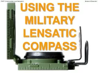
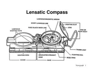
PART 1 Basic Land Navigation. USING THE MILITARY LENSATIC COMPASS. Module 2 Map Margin. PART 1 Basic Land Navigation. Module 2 Map Margin. WARNING.

E N D
PART 1 Basic Land Navigation USING THE MILITARY LENSATIC COMPASS Module 2 Map Margin
PART 1 Basic Land Navigation Module 2 Map Margin WARNING This presentation is intended as a quick summary, and not a comprehensive resource. If you want to learn Land Navigation in detail, either buy a book; or get someone, who has the knowledge and skills, to teach you in person.
PART 1 Basic Land Navigation Module 2 Map Margin NOTE To get the ideas across presented on these slides, many figures, pictures, and calculations may not be to scale and may be exaggerated for clarity.
PART 1 Basic Land Navigation Module 2 Map Margin Note: Prior to being issued any training *equipment, you will be required to sign a “statement of liability” agreeing to pay for anything you damage or lose. All items will be inspected and inventoried prior to your signature and at the end of the training day too. If you do not intend to sign this statement, then you may be denied training. *You may use your own equipment.
PART 1 Basic Land Navigation Module 2 Map Margin Any Questions?
PART 1 Basic Land Navigation Module 2 Map Margin LAND NAVIGATIONPRESENTATIONPART 1Module 2Map Margin
PART 1 Basic Land Navigation Module 2 Map Margin . . . and now on with the . . . PRESENTATION
PART 1 Basic Land Navigation Module 2 Map Margin LAND NAVIGATION WITH MAP ANDLENSATIC COMPASS
PART 1 Basic Land Navigation Module 2 Map Margin LAND NAVIGATION • Why Learn Land Navigation? • Tracking present location • Determining Distance • Sense of direction • How to read a topographic map • Terrain and map association • Spatial skills • Planning safe, practical routes • And more Navigational skills • The best way to learnLAND NAVIGATION is to get "dirt time", that is, get out there with a map and compass! • Navigation is not about finding yourself after you are lost (although that’s what happens sometimes); it’s about keeping track of your position as you move away from a known point. As you move you have to remain cognizant of the terrain you are leaving, of the terrain you are passing, and of the terrain that is ahead. • Navigation in the wilderness means knowing your starting point, your destination, and your route to get there. • These skills will allow you to venture farther off the beaten path than you ever thought before. Training and practicing land navigation on foot provides the following everyday navigation (how not to get lost) benefits; (Where am I?) (How far is it and am I there yet ?) (Where do I want to go and where am I actually going ?) (Do I understand the map ?) (What hill or river am I looking at ?) (Can I mentally visualize the landscape in 3D ?) (Take a long safe route or a short risky route ?)
PART 1 Basic Land Navigation Module 2 Map Margin • THIS PRESENTATION IS DIVIDED INTO FOUR PARTS • ________________________________________________________________________________________________________________________________________________________ • PART 1 Basic Land Navigation • The Lensatic Compass module 1 • The Topographic Map modules 2, 3, 4, • The Land and Map Association modules 5, 6 • PART 2 Intermediate Land Navigation • Making Sense of Direction module 7 • Tracking Present Location modules 8, 9, 10, 11 • Determining Travel Distance modules 12, 13, 14 • PART 3 Advance Land Navigation • Navigation Methods to Stay On Course module 15 • Additional Skills of Land Navigation module 16 • Planning to Navigate module 17 • PART 4 Expert Land Navigation • Navigation in different types of Terrain module 18 • Night Navigation module 19 • Sustainment module 20
PART 1 Basic Land Navigation Module 2 Map Margin THESE ARE THE TRAINING MODULES Module 1 Lensatic Compass – parts and features, and how to sight the compass by two different methods. Module 2 Topo Map Margin – what map margin data represents, map care, and how to properly fold a map. Module 3 Topo Map Scale – map sizes and how it affects amount of detail that will be shown. Module 4 Topo Map Symbols – you must understand them; to read and speak map language to others. Module 5 Terrain Relief – shows elevation, indicates terrain features and heights of natural features. Module 6 Map Information – what a protractor is for and how a map provides four kinds of information. Module 7 Sense of Direction – lateral drift, current bearing, obstacles, back azimuth, deliberate offset. Module 8 Resection – locate position with map only. Modified resection is with a map or compass. Module 9 Intersection & Triangulation – two methods to locate position by compass. Module 10 Map Speaks Compass Language - there is no need to orient the map to find your position. Module 11 Plotting Position Coordinates – exact positioning, used to communicate to others with a map. Module 12 Route Measure – mapping straight-line distance, curvature distance, and slope distance. Module 13 Pace Count – using ranger pacing beads and estimating hiking speed. Module 14 Travel Distance Estimation – estimating by 100 meter rule, rule-of-thumb, and by time. Module 15 Plan to Navigate – in a group or alone, equipment, safety, responsibilities, route selection. Module 16 Stay on Course – advance reference points and advance baselines. Module 17 Additional Land Navigation Skills – estimate daylight, conserve energy, blisters, weather insight. Module 18 Navigating Different Terrain – special environments, featureless terrain, visibility, dense foilage. Module 19 Night Navigation – night adaptation, protecting night vision, navigate with lensatic compass. Module 20 Sustainment – maintaining skills, training others, setting up a land navigation course.
PART 1 Basic Land Navigation Module 2 Map Margin Any Questions?
PART 1 Basic Land Navigation Module 2 Map Margin PART 1BASIC LAND NAVIGATION MODULE 2 • The Topographic Map • Map Margin • Map Care • Folding Map
PART 1 Basic Land Navigation Module 2 Map Margin THE TOPOGRPHIC MAP Without ever having been to a particular place, and with out talking to someone who has been there, you can already know quite a lot about it with a map. A map is a graphic representation of the earth’s surface drawn to scale, as seen from above. It uses colors, lines, symbols, and labels to represent features found on the ground. However, the finest maps available are worthless unless the map user knows how to read them.
PART 1 Basic Land Navigation Module 2 Map Margin TOPOGRAPHIC MAPDESCRIPTION • Reading a map is a language composed of lines, colors, and symbols. • Five basic colors are used for Topographic Maps. • Brown (Contour Lines) • Black (Man Made Features, Roads, Trails) • Blue (Water Features) • Green (Vegetation) • Red (Highway and Land Grids) • Two minor colors • Pink (Built up area, civilization) • Purple (Updated Map Information) • Symbols are used to represent the natural and man-made features of the earth. • Lines show relief and elevation; it indicates variations in terrain features and heights of natural features. • Every map has Margin Information about the map. • Maps come in three scale sizes; SMALL, MEDIUM, and LARGE. Which affects the amount of area covered and detail that will be shown. • A map is read for four basic kinds of information. • Direction • Distance • Position • Identification • Maps must be taken care of and properly folded for field use.
PART 1 Basic Land Navigation Module 2 Map Margin Map Margin Information • A map could be compared to any piece of equipment, in that before it is placed into operation the user must read the instructions. • It is important that you know how to read these instructions. • The most logical place to begin is the marginal information and symbols, where useful information telling about the map is located and explained. • All maps are not the same, so it becomes necessary every time a different map is used to examine the marginal information carefully.
PART 1 Basic Land Navigation Module 2 Map Margin Map Margin Information The top left corner of all USGS topographic maps carries the imprint of the authority responsible for the mapping of the United States
PART 1 Basic Land Navigation Module 2 Map Margin Map Margin Information In the upper right corner is the complete quadrangle name. The state is also given, as may be the county. Also included is the area covered and the type of map.
PART 1 Basic Land Navigation Module 2 Map Margin Map Margin Information • In the bottom right corner of the map is a • key to roads on the map. • Map name and state. • date of the map - one of the most significant pieces of information available. • quadrangle location shown as a black square superimposed on a state map.
PART 1 Basic Land Navigation Module 2 Map Margin Map Margin Information • At bottom center is the • map scale ratio – size of area covered and terrain detail. • Distance bar scales show several alternative units for the measurement of distance. • the contour interval. The contours are the brown lines.
PART 1 Basic Land Navigation Module 2 Map Margin Map Margin Information • In the lower left corner is the credit legend, a complex of information. And the following • the magnetic declination. • The star indicates true north: the direction of the North (rotational) Pole • "MN" indicates the direction of the North Magnetic Pole • "GN" (Grid North), the Universal Transverse Mercator (UTM) grid.
PART 1 Basic Land Navigation Module 2 Map Margin Map Margin Information • Additional information is distributed around the entire map margin. (only “need to know” itemsare circled) • (1) names for adjoining quadrangle maps (in black). Adjacent to corners and centers of the map sides. • (2) In red are the distances by road to the nearest towns. • (3) The spherical grid, latitude and longitude, complete coordinates are given at each corner of the map. • (4) the UTM (in black lettering with blue tics) and the UTM grid is in kilometers. (1) (4) (1) (1) (1) (1) (3) (2) (4) (1) (1) (1) (1)
PART 1 Basic Land Navigation Module 2 Map Margin Any Questions?
PART 1 Basic Land Navigation Module 2 Map Margin Map Folding and Map Care • Maps should be correctly folded. • Maps should be folded to make them small enough to be carried and still be available for use without having to unfold them entirely. • After a map has been folded it should be placed in a folder for protection. This will prevent the corners and edges of the map from wearing out and tearing easily when opened. • It is hard to navigate accurately with a dirty, grimy, wet or damaged map. Take care of your map and it will take care of you. • Most maps are printed on paper and require protection from water, mud, weather, and tearing. • Whenever possible, a map should be carried in a waterproof packet to prolong its life. • Waterproofing maps. • Marking a map. • If it is necessary to mark a map, use light lines so that they may be erased without smearing or smudging. If the margins of the map must be trimmed note any marginal information which may be needed, such as grid data or magnetic declination data, on the back of the map. • Special care should be taken of a map that is being used in any situation, especially in a small group; the mission may depend on that map. All members of the group should know the map’s location at all times.
PART 1 Basic Land Navigation Module 2 Map Margin Map Folding Technique # 3 Technique # 1 Technique # 2
PART 1 Basic Land Navigation Module 2 Map Margin Any Questions?
PART 1 Basic Land Navigation Module 2 Map Margin Note: Prior to being issued any training *equipment, you will be required to sign a “statement of liability” agreeing to pay for anything you damage or lose. All items will be inspected and inventoried prior to your signature and at the end of the training day too. If you do not intend to sign this statement, then you may be denied training. *You may use your own equipment.
PART 1 Basic Land Navigation Module 2 Map Margin TESTING Now it is time for the following . . . • Written exam • Hands-on / Outdoors exam
PART 1 Basic Land Navigation Module 2 Map Margin THE END OFLAND NAVIGATIONPRESENTATIONPART 1Module 2Map Margin