Download
1 / 21
240 likes | 627 Vues
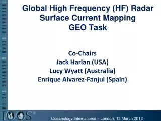
Global High Frequency (HF) Radar Surface Current Mapping GEO Task. Co-Chairs Jack Harlan (USA) Lucy Wyatt (Australia) Enrique Alvarez-Fanjul (Spain). Oceanology International – London, 13 March 2012. GEO Work Plan 2012-2015.

E N D
Global High Frequency (HF) RadarSurface Current MappingGEO Task Co-Chairs Jack Harlan (USA) Lucy Wyatt (Australia) Enrique Alvarez-Fanjul(Spain) Oceanology International – London, 13 March 2012
GEO Work Plan 2012-2015 • Endorses a task to plan a Global HF Radar Network for data sharing and delivery and to promote the proliferation of HF radar surface current velocity measurements. • This GEO task is mentioned under • IN-01 Earth Observing Systems • SB-01 Oceans and Society: Blue Planet
Global Component: Global Ocean Observing System for Climate Total in situ networks 61% 87% 100% 59% 81% 100% 62% 73% 48% 34% HF Radar Currents ?
Responding to Crisis: Deepwater Horizon • U.S. IOOS partnership demonstrated ability to: • Quickly deploy technologies: Gliders and HF radar, saving resources/improving safety • Models/Imagery ingested into NOAA/Navy models • Data assimilation improved spill response decision-making and public understanding USM HFR TS Bonnie USF HFR HFR data informed NOAA trajectory forecasts HFR validation of SABGOM Forecast with satellite detected oil slicks Web Portal Briefing Blog
Outline: Goals • Background Discussion – • Current status of HF radar globally • Existing national programs • Current status of HF data management • Existing applications examples • Radio Frequency Management • Synergies & Challenges • Next steps • Focused working groups? • Other?
CODAR SeaSonde Worldwide 2012 • United States 130 • Canada 8 • Mexico 2 • Brazil 2 • Bahamas 2 • Honduras 2 • Norway 6 • Portugal 4 • Italy 6 • Croatia 2 • Spain 16 • Ireland 2 • Russia 1 • France 2 • Israel 2 • Japan 22 • Korea 24 • China 8 • Thailand 6 • Malta 2 • Taiwan 20 • India 12 • Vietnam 3 • Indonesia 2 • Jordan 1 • UAE 2 • Egypt 2 • Azerbaijan 2 • Australia 5 Total Sales: ~298
USA: 12 Mexico: 2 France: 6 Australia: 8 Germany: 5 UK: 2 Chile: 2 Oman: 2 Greece: 2 China: 4 Korea: 2 Total Sales: 47 WERA Worldwide 2012
Present US HF Radar Network 129 Radars of Four Range/Resolutions* Maximum Ranges: 25-200 km Resolution: 500 m - 6 km Some Radars Deployed since early ’90s 44 CODAR Radars Purchased by California Coastal Ocean Current Monitoring Program (~2003-2004) *Does not include 3 seasonal radars
Mid-Atlantic USA NYC DC
Data Management • Standard interoperable self-describing netCDF format • Standard metadata ISO 19115 format • Quality control • Radar level • Radial velocity level • Total vector velocity level • Three Data Nodes • Ten Aggregator Server Portals
IOOS HF Radar Data Flow3 Data Nodes US Coast Guard Search & Rescue Only 3 radars and 1 Aggregator shown
US Coast Guard Support • R&D to Create HF Radar Tools • Integrated into USCG Operational SAR Optimal Planning System (SAROPS) for Mid-Atlantic in 2009 • Refines search zone 96 hr: Without HFR (36,000 Km2) 96 hr: With HFR (12,000 Km2) 15
Applications • Oil Spill Response; 24x7 availability a must. • HFR was used as a cost avoidance tool during oil spill in San Francisco Bay • Water Quality Monitoring • San Francisco’s accidental discharge of secondarily-treated wastewater. • San Diego, Dept of Environmental Health uses the Tijuana River Plume Trajectory to help guide decisions about sampling and beach closures. • Los Angeles used HFR data to determine beach closures during a major maintenance operation of a 50-year old outflow pipe. ~$750M in unneeded repairs could have been avoided had the HFR data been available in previous years. • Commercial Marine Navigation. • Ship captains use HFR data in a display environmental conditions at the entrance to the Ports of Los Angeles and Long Beach Harbor. • Criminal Forensics: Conviction (fine) of a Dentist for dumping medical waste which washed up on the New Jersey shores. Using HFR they were able to hindcast where the needles came from. • Offshore Energy: New Jersey has funded 4 radars to support offshore energy siting. Also it is to be ingested into oceanic models that will provide better forecasts for all types of offshore energy operations. • Marine Fisheries: HFR data are being used to monitor the dispersal of commercial fish larvae & juvenile fish survival. • Harmful Algal Bloom (“red tides”): HFR data are being used in the forecasts for the Washington Coast.
Water Quality & Fisheries Plume tracking Fisheries Tracking pollution from the Tijuana River in Southern CA Persistent Upwelling Positive Correlation Negative Correlation Persistent Downwelling • Start Points • Stop Points Are there preferred locations for the fall squid migration to the outer shelf? Squid prefer persistent upwelling zones.
Radio Frequencies • World Radiocommunications Conference Feb 2012 • Frequency bands for global use* • 4.438 - 4.488 MHz 50 kHz • 5.250 - 5.275 MHz 25 kHz • 9.305 - 9.355 MHz 50 kHz (not usable in the Americas) • 13.450 - 13.550 MHz 100 kHz • 16.100 - 16.200 MHz 100 kHz • 24.450 - 24.650 MHz 200 kHz • 26.200 - 26.420 MHz 220 kHz • 41.015 - 41.665 MHz 650 kHz • 43.350 - 44.000 MHz 650 kHz • 25 kHz = 6 km range resolution • 50 kHz = 3 km • 150 kHz = 1 km * status depends on ITU Region
Synergies & Challenges • Synergies • WRC frequency allocations • Data file formats • Challenges • Data file formats • Data distribution: technical & political • Data assimilation into operational models • Frequency synchronization
An Operational HF Radar Network Boston New York Washington