Download
1 / 23
240 likes | 448 Vues
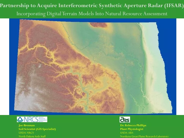
Joe Brennan Soil Scientist (GIS Specialist) USDA-NRCS North Dakota Soils Staff. Dr. Rebecca Phillips Plant Physiologist USDA-ARS Northern Great Plains Research Laboratory. Partnership to Acquire Interferometric Synthetic Aperture Radar (IFSAR).

E N D
Joe Brennan Soil Scientist (GIS Specialist) USDA-NRCS North Dakota Soils Staff Dr. Rebecca Phillips Plant Physiologist USDA-ARS Northern Great Plains Research Laboratory Partnership to Acquire Interferometric Synthetic Aperture Radar (IFSAR) Incorporating Digital Terrain Models Into Natural Resource Assessment
Series of Coordinates Surface Representation Terrain Model Elevation Values Elevation Technology Background What is a DEM? Digital Elevation Models (DEM) or Digital Terrain Models (DTM)
30 meter DEM Elevation Coordinates – 100 foot Spacing Data Widely Available Variable Elevation Accuracy – 5 -15 meter Available Free 6000 feet Elevation Technology Background Existing Technology - USGS Digital Elevation Models Very Limited Potential for Resource Assessment
10 meter DEM Elevation Coordinates – 33 foot Spacing 20% Coverage in North Dakota Variable Elevation Accuracy – 5-7 meter $10 – 20/sq mi 6000 feet Elevation Technology Background Existing Technology - USGS Digital Elevation Models Improved Potential for Resource Assessment
Elevation Technology Background Emerging Technology - LiDAR 1 meter DEM Elevation Coordinates – 2.5 foot Spacing Walsh County, Fargo, Sheyenne R. Floodplain High Elevation Accuracy – As low as 6 in. Price $100-600/sq mi. Limitless Potential for Resource Assessment 6000 feet
Elevation Technology Background Emerging Technology - IFSAR 5 meter DEM Elevation Coordinates – 16 foot Spacing California, New Mexico, South Dakota, Texas, Wyoming High Elevation Accuracy – 1 meter (or less) Price $11.27/sq mi. (NRCS Price) Most Cost Effective 6000 feet
For the purpose of assessing the spatial extent of wetland vegetation communities Remote Wetland Assessment Missouri Coteau Prairie Glacial Basins
Cities Rivers Area of Interest Missouri Coteau (Ducks Unlimited, 2003) National Wetlands Inventory (1980’s) http://wetlands.fws.gov/mapcodes.htm Remote Wetland Assessment Missouri Coteau Prairie Glacial Basins
Remote Wetland Assessment Missouri Coteau Prairie Glacial Basins Year-to-Year Variability in Water Persistence 2002 2003 2004
Remote Wetland Assessment Missouri Coteau Prairie Glacial Basins Landscape Water Coverage
Remote Wetland Assessment Missouri Coteau Prairie Glacial Basins
Soil-Landscape Modeling Missouri Coteau, MLRA 53B Existing Soil Survey Information Expert Knowledge Terrain Analysis SSURGO Experienced Soil Scientists DEM (IFSAR) Derived Layers GIS
Soil-Landscape Modeling MLRA 53B Terrain Analysis Project Repeatable Model Terrain Criteria 1 Williams Soil Series 3 – 6% Slopes Profile Position = Backslope Terrain Criteria 2 Slope Shape = Linear (Across or Down) Terrain Criteria 3 Slope = 3 – 6%
Soil-Landscape Modeling MLRA 53B Terrain Analysis Project Output – Soil Landscape Relationship Williams Soil Series 3 – 6% Slopes
NRCS Field Office Applications of IFSAR Engineering Applications Pipelines Grassed Waterways Dugouts/Ponds
NRCS Field Office Applications of IFSAR Determinations (Landscape Position) Wetland Violations (Constructed Drains)
NRCS Field Office Applications of IFSAR RUSLE2 Slope Gradient, Slope Length
NRCS Field Office Applications of IFSAR Watershed Management 3 Dimensional Conservation Planning
Vendor Quote 3892 square miles x $11.27 per square mile Price Subtotal: $43,863 ARS Uplift Area = 1297 square miles x $3.92 per square mile ARS Uplift (+35%) ARS Uplift: $5,123 ______ Total Cost: $48,986 NRCS Cost Share: $24,493 Proposal to Acquire IFSAR